Kleine Kinigat / Monte Cavalatto

Kleine Kinigat / Monte Cavalatto

Page Type Page Type: Mountain/Rock
Location Lat/Lon: 46.67940°N / 12.51740°E
Additional Information Elevation: 8763 ft / 2671 m
Sign the Climber's Log

Overview


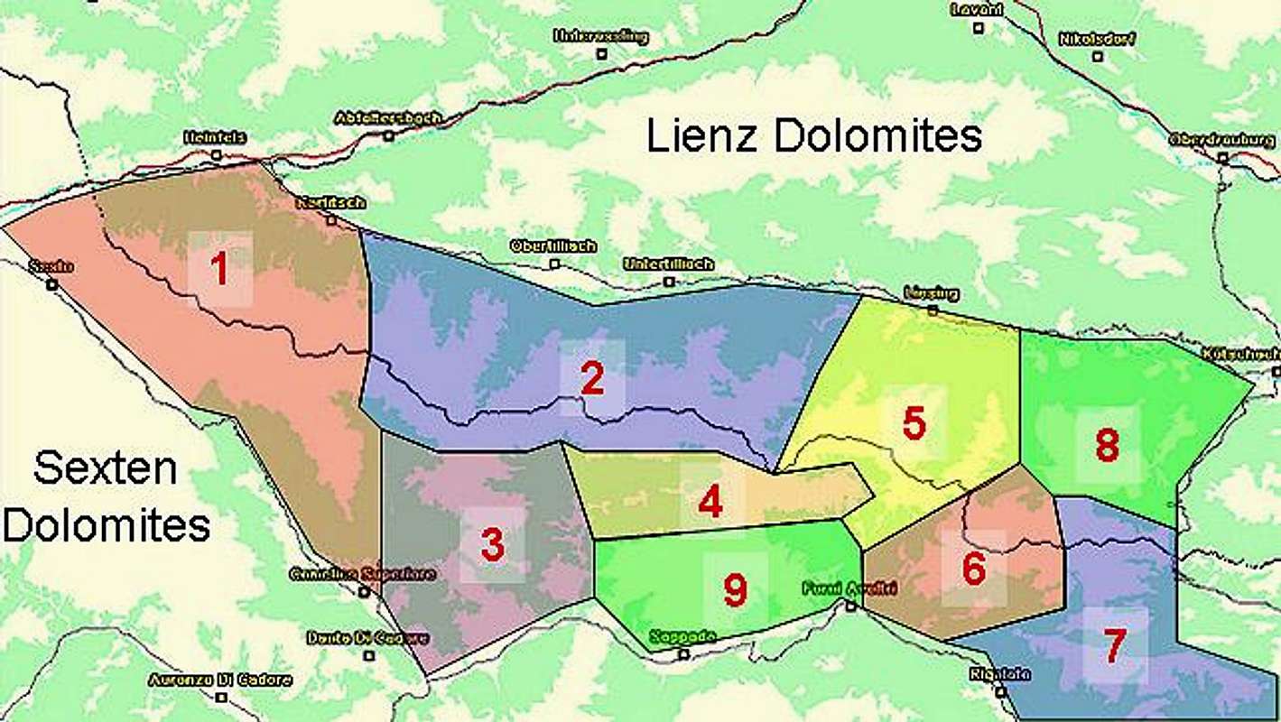
Geographical Classification : Eastern Alps > Carnic Alps > Carnic Alps Main Ridge (West) > Kleine Kinigat (Monte Cavalatto)

Kleine Kinigat photo_id=115364

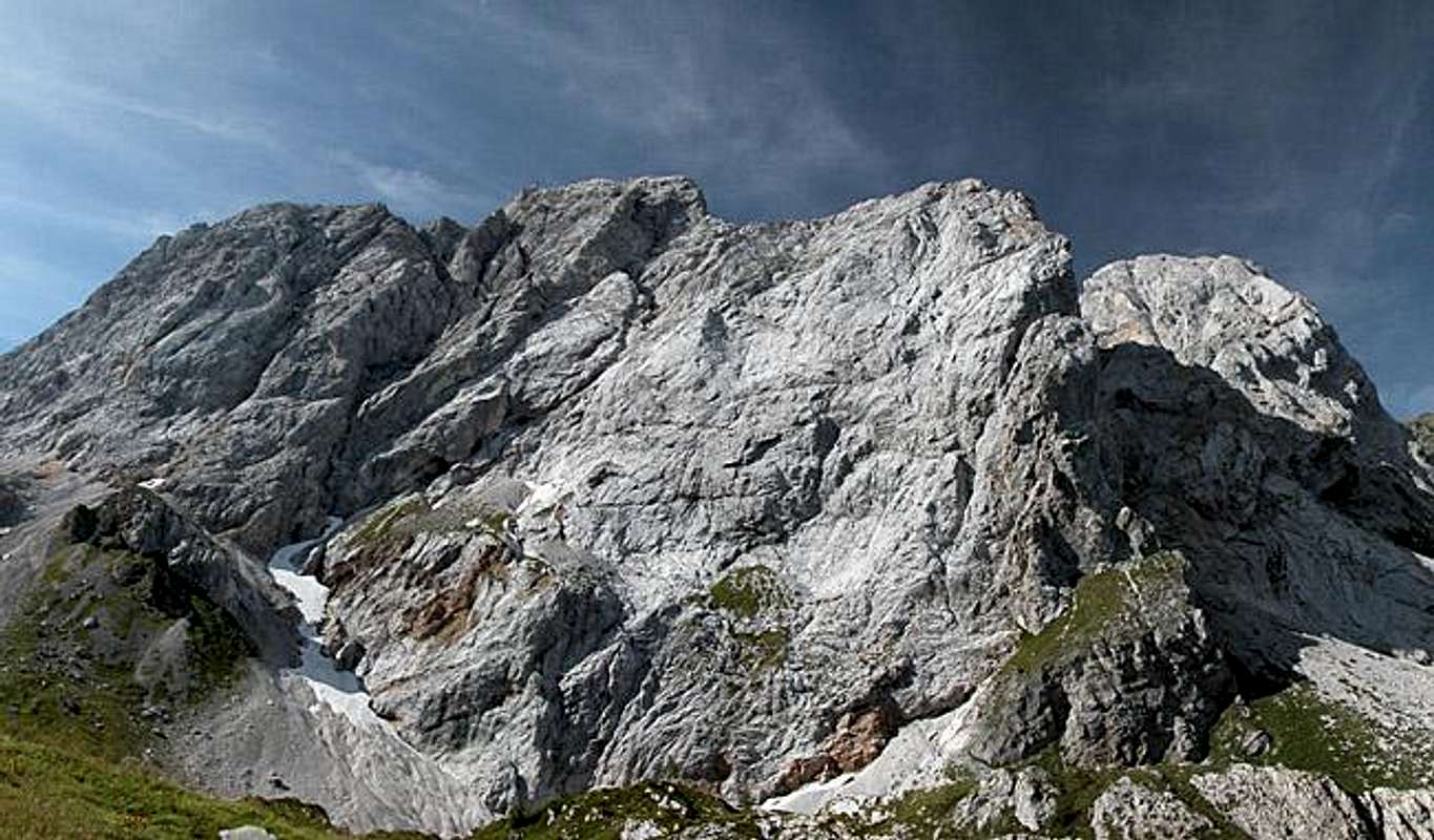
Kleine Kinigat (Italian Monte Cavalatto) is the lowest of a trinity of peaks on the Carnic Alps Main Ridge. Though it is overshadowed by the slightly higher Große Kinigat (2689m) and Königswand (2686m) from an aesthetical standpoint it is the most beautiful summit of the three. While Große Kinigat and Königswand are located so close to each other that in Italian literature they are seen as a single mountain (Monte Cavallino), Kleine Kinigat stands apart and shows a fine summit pyramid from most sides.

The rock composition however is very fragile - a lot of debris covers the steep rocky slopes. Therefore only a small number of climbing routes are known, none of which can be particularly recommended. There are only limited possibilities to place protection and you have to beware of rock fall on all of them. The situation is far different on the other two summits were lots of climbing routes crisscross the more solid faces.

The normal route to Kleine Kinigat follows the routes to Pfannspitze or Große Kinigat (please wait until they will be posted with the summits). Both head for the Carnic Alps Main Ridge and from either side close in on the mountain by trail 160. Directly to the south of the summit you can see a narrow path heading up northwards. This is the entry point to a small and narrow gully. There is a lot of scree, gravel and other debris there. Apart from that the ascent is rather easy, only once reaching UIAA grade I (need your hands). The summit view easily compares with Große Kinigat's since the mountain is only about 20m lower. However, you'll certainly have it to yourself - all other climbers will go to the taller mountain.

Kleine Kinigat photo_id=114268

The whole group was the scene of heavy fighting during World War I, like so many other places on the ridge. Here the saddle between the two Kinigats, Sandiger Boden (= Sandy Hollow) was held by Austrian troops. You are able to see the positions, still. Both Kinigats still show ascent routes which were established during this war and which have been maintained ever since 1971 when a final treaty was signed by both nations and the border was finally marked by mile (rather km) stones.

Climbing Kleine Kinigat


As already mentioned in the overview section, Kleine Kinigat is not the perfect climbing destination due to the brittleness of the rock. However there are a handful of classical climbs which I will list here. For more information see the following excellent book (in German):
Karnischer Hauptkamm
Alpenvereinsführer
P. Holl
Rother Verlag
ISBN: 3-7633-1254-4.

  • South Couloir
    Normal route, rated I in a short section. Lots of debris.
  • South-eastern ridge
    Rated III, 250m length, very fragile
  • North face
    Rated III, 300m length, very fragile
  • Western Ridge
    Rated III, 100m length, very fragile

    Views


    Kleine Kinigat photo_id=115352

    The location of the Kinigat Group close to the Sexten and Lienz Dolomites as well as the southern parts of Hohe Tauern makes all three summits great lookout peaks. Kleine Kinigat is probably the best because its relative loneliness.

    Getting There


    Western Main RidgeWest Central Main RidgeCrode dei LongerinPeralba - Chiadenis - AvanzaEast Central Main RidgeBiegengebirgeKellerwand - Hohe WarteMooskofel GroupRinaldo Group
    Interactive map of the western part of the Carnic Alps Main Ridge. The numbers refer to the respective subgroups as given on the Carnic Alps Main Ridge (West) Page. Click on them to get the subgroup description. Kleine Kinigat is located to the west of subgroup 2.

    The best starting point for an ascent of Kleine Kinigat is the village of Kartitsch in the Tyrol Gailtal Valley. The village is located on B111 the main road running through the Tyrol Gailtal and Lesachtal Valleys. The trailhead (there are two ascent routes starting from the same trailhead) is located a little southwest of the village near the sports field. Kartitsch can be reached as follows:

    From the West (Brenner Motorway A22)
    Leave the Brenner Motorway near Brixen / Bressanone and follow SS49 to the east through Pustertal / Val Pusteria. To the east of Innichen / San Candido you cross the Austrian-Italian border and follow the road (now B100) to Tassenbach. Turn right (south-east) here onto B111, which you follow in direction Kartitsch. In Kartitsch at the grocery store turn right into the village and follow the signs to the sports field.

    From the North
    There are two possible roads:
    • From Kitzbühel over B108 through the Felbertauern Tunnel to Lienz, then southwest to Tassenbach (B100), where you turn on to B111 east into the Tyrol Gailtal.
    • From Salzburg along motorway A10 to Spittal. Turn west on B100 to Oberdrauburg, there south to Kötschach-Mauthen were you turn east on B111. You need to go through the whole Lesachtal Valley to reach Kartitsch.

    From the South (Udine)
    Take Motorway A23 to the exit Camia Tolmezzo. Follow SS52 north to Tolmezzo where you turn onto SS52 bis. This leads to Plöckenpass, where it crosses the Austrian-Italian border. In Austria the road turns into B100 and at Kötschach-Mauthen you have to turn east on B111 into Lesachtal Valley. Again, go on through the whole valley to Kartitsch.

    Red Tape


    Kleine Kinigat photo_id=115356

    There is no real red tape. The mountain is located directly on the Austrian - Italian border so an ID-card is certainly a good idea. Also free camping is discouraged. The nearest refuges are at Obstanser See to the west and Filmoor Saddle to the east so getting a place to rest shouldn't be a problem. The proprietors of the huts will let you camp nearby.

    When To Climb


    The mountain can be climbed all year round. In fact due to the debris an ascent in snowy conditions might even be easier than an ascent during the summer. Kleine Kinigat, however is not popular in either season since the big sister is so close by.

    Accommodation


    As said above camping on the border is discouraged. Stay at the refuges (see here) or at one of the little campgrounds in Lesachtal Valley. The latter are mostly associated with an inn or hotel. If you are looking for hotel rooms or apartments follow one of the links below

    Weather Conditions


    In general the weather in south-eastern Austria is much better than in the northern and western parts of the country. Still, the Carnic Alps Main ridge is a weather divide in northern or southern wind conditions so it pays to keep informed. Look at one of the links below or (even better) call the proprietors of the huts. You'll find all phone numbers on the Carnic Alps Main Page.

    Maps 'n' Books


    Maps
    I have been using maps by Kompass Verlag, which are very good for the hiking trails though they don't show ALL the relevant summits of the area.
    • Lienzer Dolomiten / Lesachtal
      1:50000
      Kompass Map WK47
      Kompass Verlag
      ISBN: 3-85491-053-3
    • Tabacco Map 10: Sesto
      1:25000

    As for books please look at the appropriate section of the Carnic Alps page.