
-
 12875 Hits
-
 86.37% Score
-
 22 Votes
|
|
Mountain/Rock |
|---|---|
|
|
46.40972°N / 13.80874°E |
|
|
Hiking, Mountaineering, Skiing |
|
|
Spring, Summer, Fall, Winter |
|
|
7906 ft / 2410 m |
|
|
What's New On This Page?
- Jan 17th, 2019: Design corrections.
- Mar 3rd, 2018: Small design edits.
- Nov 3rd, 2004: Initial setup of the page.
Overview

The last steps to the summit
Križ (križ=cross) is a mountain, which you ascend passing by. Mountaineers, who come from Krnica valley over Kriška stena, ascend its summit and proceed to Pogačnikov dom (hut) or further to Stenar, others who were sleeping in the hut come up to its high ridge when going towards Škrlatica - and also visit its summit, and so on. Only in times of tour skiing season Križ can be the ultimate goal of a tour.
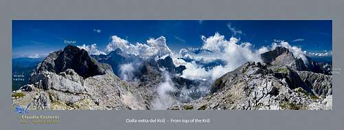
The mountain has no high walls. It rises from the high plateaus of Kriški podi and Na Rušju as a ridge, stretching between Stenarska vratca (notch), 2295 m, on the SE and the edge of Kriška stena (wall), 2375 m, on the NW. The summit is easily accessible, once you reach its high summit ridge. But reaching it from any of the three surrounding valleys takes quite some time. From the summit you have a nice view on the surrounding summits: Stenar, Triglav, Bovški Gamsovec and Pihavec, Planja and Razor, Prisojnik and Škrlatica group.
Getting There
For the general orientation see the Julian Alps group page.
- The eastern ascent starts in Vrata valley. The end parking place can be reached from Mojstrana in 2 h walk, by car or by bus.
- The southwestern ascent starts in Zadnjica valley. The parking place can be reached from Trenta Valley in 30 minutes walk or by car.
- The northwestern ascent starts in the Krnica valley. The end parking place can be reached from the Vršič pass road in 30 minutes walk or by car.
Maps:
- Julijske Alpe - Vzhodni del (Eastern part). Planinska zveza Slovenije. 1:50.000
- Julijske Alpe - Triglav. Planinska zveza Slovenije. 1:20.000 - recommendable.
Routes Overview
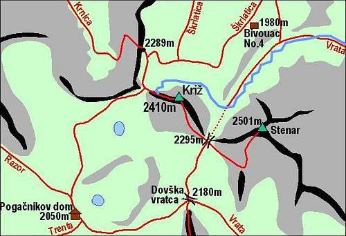
Kriz and its marked paths
1. From Aljažev dom (hut), 1015 m, through Sovatna (valley/ravine) on Dovška vratica (saddle), 2180 m, on Stenarska vratica (notch), 2295 m, and to the summit. Steep marked path. 4 h.
2. From Aljažev dom (hut), 1015 m, to Bivouac IV, 1980 m, to the edge of Kriška stena and to the summit. Steep marked path. 4 h.
3. From Krnica valley. From the parking place in 30 minutes to Koča v Krnici (hut), 1112 m, to the end of Krnica, over Kriška stena (wall) and to the summit. Marked, over the wall exposed, ferrata. 4 h.
4. From Zadnjica valley. From the parking place, 700 m, to Pogačnikov dom (hut), 2052 m, to the edge of Kriška stena and to the summit. Steep marked path. 5 h.

Ascending behind the Stenar (left) towards the Stenarska vratca (notch). Križ is on the right.
For tour skiing, the route #2 is preferred. You can have a steep, demanding downhill also by the route #1. The variant of the route #2 in winter goes also towards Stenarska vratca (notch). How to reach the valley below Stenarska vratca, see the Stenar ski tour description! From below Stenarska vratca you cross the slopes around Križ north face and so reach the edge of Kriška stena and by the NW summit ridge the highest point. This is also the preferred downhill - very nice!
Red Tape
The mountain is in the Triglav National Parc, otherwise no limitations.
When To Climb
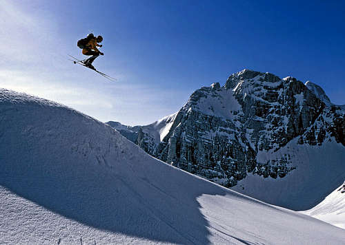
Skiing on the summit ridge of Križ. Behind is the Stenar, 2501 m.

Before the ski descent
In summer and autumn - the best months are July to October. For tour skiing the best months are March to May. For weather see here. Even better site is wunderground - here's the direct link to Kredarica station, 2515 m (below Triglav summit).
Camping
In the neighbourhood of Križ the following mountain huts can be used:
- Aljažev dom, 1015 m, (04) 5891030, (031) 384011, (031) 384013,
- Koča v Krnici, 1113 m, (041) 654339,
- Koča Zlatorog in Trenta valley, 622 m,
- Pogačnikov dom, 2050 m, (051) 221-319,
- Bivak IV na Rušju, always open.