
|
|
Mountain/Rock |
|---|---|
|
|
46.44351°N / 13.69339°E |
|
|
Hiking, Mountaineering, Trad Climbing, Ice Climbing, Big Wall, Mixed, Scrambling, Skiing |
|
|
Spring, Summer, Fall, Winter |
|
|
7431 ft / 2265 m |
|
|
Overview
Geographical structure: Eastern Alps > Julian Alps > Mangart and Jalovec group > Strmi Strug.Between Mangart, 2678m, and Jalovec, 2645m, from the Main Julian Alps a strong side crest spans towards north. Attached to the main crest on V Koncu spica, 2350m, it goes over the strong Vevnica, 2340m, Strmi Strug, 2265m, Zadnja Ponca, 2265m, Srednja Ponca, 2228m to Visoka Rateska ponca, 2272m, which is the last high mountain in this wall. More towards north it drops significantly to Vratica notch, 1844m, above which Mala Ponca, 1925m, stands and then the crest gets lost in woods above the upper Sava valley.
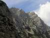
The photo of Strmi Strug on other pages.
If you look to the Ponce chain from Tamar valley you will see first the Visoka Ponca then long Srednja Ponca, Zadnja Ponca and then the steep and airy Strmi Strug. Strmi Strug is located on the frontier crossing between Slovenia and Italia. To the south side is over the famous ridge connected with Vevnica and to the north side is connected with Zadnja Ponca. The whole crossing of this ridge from Visok Ponca to the Vevnica is described here as the Crossing Ponce chain. On the east side fall from the top of Strmi Strug the steep and wild face and slopes. I haven`t heard for any ascends in this face! On the west side of Strmi Strug is another steep face to the Italian side and over this face go some climbing routes and also one marked (?) and secured route. The west face was climbed also by Julius Kugy.
Not many climbers reach the Strmi Strug but only the climbers that are crossing the ridge from Ponce to the Vevnica. It is hard mountain and only for the good and experienced climbers.
 |  |  |  |  |
Getting There

The detailed map. Red spots are summits, posted on SP.
For the general orientation see the Julian Alps group page and the Mangart and Jalovec group page!
For the east ascent (the crossing from the Ponce ridge and then to the Vevnica) you must reach Ratece village in Sava valley and drive in Planica side valley to Tamar alpine meadow, where the trailhead starts. The upper Sava valley can be reached from the Central Slovenia (via Jesenice), from Italy (via Tarvisio) or from Austria (via Karavanke tunnel or one of passes over Karavanke ridge).
For the west ascent you must reach Belopeska jezera / Laghi di Fusine below Mangart. Driving from Tarvisio (highway exit), you reach Bela pec / Fusine and take a good, narrow road towards south.
Maps:
 |  |
Routes Overview
There are only two popular approaches on the summit of the Strmi Strug.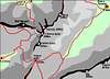 ----> The map of the area of Strmi Strug
You can find information for climbing routes in the west face on other pages in the nearness of the Strmi Strug or on the Mangart and Jalovec group page!
Red Tape
No limitations but Strmi Strug is located in Triglavski Narodni park so you must be kind to the nature and other beauties.The only thing you might pay is parking on selected locations.
When To Climb
In summer and autumn - the best months are July to October.In early summer on the west side (Italian side) are often big snowfields and somewhere are constant which can make you ascend harder. You must take an ice-pick and crampons with you.
 |
Mountain Huts
There are two huts. Dom v Tamarju, 1108m is in Slovenia in Tamar valley and Rif. Zachi, 1360m is in Italia.On the ridge is Bivouac called Bivak Rob nad Zagacami, 2160m. It is very nice bivouac in the beautiful area and it is very nice supplied.
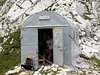 ----> The Bivouac of Alpine Club Tarvisio
Bivouac of Alpine Club Tarvisio (e-mail: caitarvisio@inwind.it, address: Municipio di Tarvisio, via Roma 3, 33018 Tarvisio (UD), tel. 042-82037), 2160m, allways opened, 9 beds, below Zagerica notch. By Via della Vita 3h from Rif. Zacchi, through Koritnica valley over Zagerica notch 4h 30min.
Camping
Camping inside the National Park is forbidden. Beside the mountain huts there are plenty of hotels and private apartments in the towns and villages, which surround the area. Here are few links where you can find info on accommodations closer and further away:Kranjska Gora
Bovec
Mojstrana
Bled
Mountain Conditions
Mountain conditions in Julian Alps are well known, thanks to Kredarica (2515m) hut and meteo station, which is bellow the Triglav.You can observe current conditions and forecast for Kredarica on the Wunderground meteo site. Here is direct link to Wunderground - Kredarica page.
Some weather informatin can also be found here.