
-
 22951 Hits
-
 77.48% Score
-
 8 Votes
|
|
Mountain/Rock |
|---|---|
|
|
40.06800°N / 77.249°W |
|
|
1530 ft / 466 m |
|
|
Overview
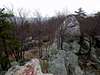
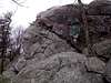
Hammonds Rocks is another of the many great summits within Michaux State Forest on South Mountain. This summit is directly northwest of Laurel Lake and on clear days affords fine views down to the lake and Pole Steeple , . This large rock outcropping is massive and not a regular sight within the state of Pennsylvania unless you are in the Pine Creek Gorge at the PA Grand Canyon . The most prominent features are the two rock pinnacles that stick up straight out of the top of the ridge. They are very oddly placed and it seems as though you could almost push them over. Needless to say, you will find plenty of scramling and technical routes here. Besides the technical routes, there is one trail which heads north to south for Hammonds Rocks and it is blazed in red. The trail is about two miles in length and doesn't gain more than a couple hundred feet. The trail itself is pretty limited on views, but once you reach the summit they become plentiful.
Hammonds Rocks is on the crest of the northern South Mountain Massif and can be viewed from Pole Steeple , across the valley. Geologically, this summit is an exact replica of Sunset Rocks and Little Rocky Ridge a couple miles south. You will find numerous dikes of quartz invading the sandstone outcroppings.
You can access this summit via a road (Ridge Road) as well with a short hundred yard walk. That makes the summit accessible to everyone, no matter what your desire. The trail does make for a nice little hike though and great views.
 |  |  |  |
Getting There
From Harrisburg:
Take Interstate 81 south to Carlisle and the exit for Rt. 34 S. You'll want to exit onto 34A which comes after 34B. Follow Rt. 34 south for five miles to Mt. Holly Springs and continue through town. At just under one mile outside of town you'll reach a turnoff for Ridge Road, just past a restraunt, and right before you reach the intersection with PA 94. Take Ridge Road up the mountain past the Spruce Run Vista. After about six miles you'll reach the trailhead on your left which is blazed in red. To drive up to Hammonds Rocks, continue on the road until it comes into view.
From Gettysburg:
Head west out of town on the Lincoln Highway (Route 30) into the mountains. After nearly fifteen miles you will have reached an intersection with signs that point you north to Pine Grove Furnace State Park and Caledonia State Park. Turn here and head towards the parks on PA 233 all the way through Caledonia and into Pine Grove Furnace State Park. Continue to the north end of the park and just past Laurel Lake where you'll see the sign for Cold Spring Road on your left. Follow this road up the mountain to its intersection with Ridge Road at about four miles. Take ridge road for two miles until you reach the trailhead on your right. It is blazed in red. To drive right up to Hammonds Rocks, continue up the road until they come into view.
 |  |
Red Tape
There are no premits or fees required to hike or climb here. The only seasonal closures would be due to snow. If you do attempt this hike in winter conditions make sure you are properly prepared for PA's sometimes harsh winter conditions. For conservation purposes follow the “LEAVE NO TRACE” program and you'll be fine.
When To Climb
This mountain is climbable at all times of the year. The best time to climb for views would be in early to mid October because of the "Fall Foliage". In winter conditions may be more difficult near the summit because of ice so be careful.
Camping
There is no camping allowed in the immediate area of Hammonds Rocks. In the valley below is Tagg Run Campground which accepts reservations throughout the year.
Mountain Conditions
For current and up-to-date weather information click on the link below!
weather.com
Cascade Scrambler - May 22, 2008 7:05 pm - Hasn't voted
Route from Gettysburg isn't quite right (we think)We followed these directions exactly, and we had to have some locals get us pointed in the right direction. Ridge Road is 2.3 miles up Cold Spring Road, not 4 miles. Although it's unmarked, it feels obvious, because it runs right on top of an obvious ridge. After you take a right on Ridge Road, you reach Hammonds Rocks in .75 of a mile. We drove the two miles mentioned in the "Getting there", but although we saw an obvious parking area, we didn't see any red blazes. It's still a nice area, grafitti aside.
Cascade Scrambler - Jun 2, 2011 11:12 am - Hasn't voted
broken linkYour link to Michaux State Forest is broken. It should be: http://www.dcnr.state.pa.us/forestry/stateforests/michaux/index.htm