
|
|
Mountain/Rock |
|---|---|
|
|
43.10000°N / 19.00000°E |
|
|
7831 ft / 2387 m |
|
|
Overview
 Below Minin Bogaz (2387 m)
Minin Bogaz (2387 m) belong to group of highest and most popular peaks of DURMITOR.
Durmitor's "Ama Dablam", as some peoples called this ALPINE NEEDLE, is one of most attractive Durmitor's peak for climbing. Specially in winter time, Minin Bogaz summit climbing is extraordinary exciting enjoyment and unforgetable experience.
It’s name being after a certain hunter Mina who on this peak or thereabout had his ambush-place.
 Durmitor massif
From streets of Zabljak town you can see amazing alpine needle of Minin Bogaz peak, which with Bobotov Kuk (2523 m) peak create incredible and impressive alpine scenery above Zabljak town and Durmitor massif. This view is really something what you must to see.
North Face of Minin Bogaz with it's alpine needle or some kind of dagger or knife, really deserve a image of Durmitor's "Ama Dablam". Of course, this is just expression of local inspiration.
LOCATION:
It's harshly crest is situated in the heart of DURMITOR massif. West Face of Minin Bogaz staying above Valoviti Do rocky basin. East Face proudly dominates above beautiful glacial lake Zeleni Vir (2028 m), which is paradise for camping of climbers and nature lovers. Near Zeleni Vir lake exist also a water spring. On grass near lake you can put on the ground your bivaouc and resting for tomorrow's climbing in surrounding area.
 Alpine needle Minin Bogaz (2387 m)
SUMMIT VIEW:
E side are Zupci (2309 m, Teeths) who have image of "Protector of Bobotov Kuk" peak.
More SE from Minin Bogaz are Bandijerna (2409 m) and Milosev Tok (2426 m). North Faces of Bobotov Kuk (2523 m) and Bezimeni Vrh (2487 m) can be wonderfully seen from Minin Bogaz summit, above Valoviti Do rocky basin. Very spectacular is view to Bobotov Kuk.
Also, E summit view look to beginning of Komarnica river canyon, which start between Boljske Grede (2204 m) and Lojanik (2091 m) crest.
SE view look to beautifully trademark of Durmitor, Stit (Sareni Pasovi, 2248 m).
Lonely Terzin Bogaz (2303 m) and other peaks as are Sljeme (2455 m), Medjed (2287 m) and Savin Kuk (2313 m), can be also seen from Minin Bogaz summit, in E and NE direction.
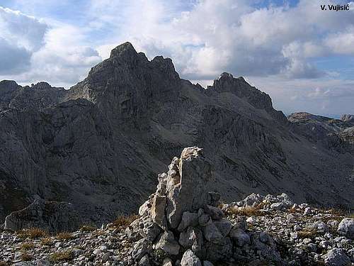 Bobotov Kuk & Bezimeni Vrh from Minin Bogaz
 |  |  |  |  |
Routes Overview
MININ BOGAZ (2387 m):It is the most needle-like of all Durmitor’s peaks. It’s peak is like an alpine needle.
~Route: Zabljak (1540 m) - Katun Lokvice (1800 m) - Biljegov Do (1965 m) - Sagorjele Ploce (2120 m) - Minin Bogaz (2387 m): 4.15 h. It's no easy tour - the walking is over some rough space, and it takes time. Whole day tour, about 9 hours.
 |  |  |  |
Getting There
Gateway to climbing Minin Bogaz (2387 m) peak in DURMITOR massif is Zabljak town. Information how to get there: Below S side of Minin Bogaz (2387 m)
By Plane
~To Beograd (Belgrade, Serbia&Montenegro capital) airport. Than with plane to Podgorica, capital of Montenegro, or with bus or car to Zabljak town.
~To Podgorica airport. Than with bus or car to Zabljak town.
Information about flights find on the sites of JAT Airways, a former Yugoslav airlines, or on Montenegro Airlines.
By Bus
~Beograd (Belgrade)-Zabljak
~Podgorica-Zabljak
~Niksic-Zabljak
~Pljevlja-Zabljak
Buses go to Zabljak from Beograd (Belgrade) twice a day and from Podgorica, Niksic, Pljevlja and Mojkovac several times per day.
By Car
~Beograd (Belgrade)-Zlatibor-Nova Varos-Prijepolje-Pljevlja-Zabljak
~Niksic - Savnik (47km) - Zabljak (37km): 84km; Niksic to Zabljak approach from south.
~Niksic - Savnik (35km) - Zabljak (37km): 72km;
~Podgorica - Niksic (55 km)-Savnik (47 km)-Zabljak (37 km): 139 km; Add this length if you are going to Zabljak from Podgorica via Niksic. Road to Niksic from Podgorica is good.
~Podgorica - Kolasin (71km) - Mojkovac (21km) - Zabljak (67km): 159km; road is good all the way to Zabljak. Behind Podgorica (56m) you go inside Moraca River canyon (one of spectacular Montenegrin canyons). It is up to 1000m deep and has wild sides. That's spectacular drive. After that, from "Djurdjevica Tara" bridge to Zabljak - 23 km.
 |  |  |  |
When To Climb
 On the summit ridge
You can climb during all year seasons, but ideal period for climbing is mid June - mid September.
During the winter, Durmitor usually switches into ski resort. Under Savin Kuk peak (2313 m) is Durmitor Ski Center. (gondolas, ski lifts, chair lifts, restorants and their customers).
Crno Jezero (Black Lake) location is a common climbing starting point. All major trails further uphill are well marked with white circle/red border marks.
Whole Durmitor mountain is very good marked. Thanks to Branislav Cerovic, greatest knower and devoter of Durmitor National Park, who marked all routes on Durmitor mountain.
 |  |  |  |
Camping
 Zeleni Vir (2028 m) lake is placed below Minin Bogaz
Inside of Durmitor National Park camping is permitted on camping dedicated spots only.
Major huts are in good condition, but with no service. Still, open to the general public. Hikers/climbers are supposed to bring all the jummy stuff with them.
 SE side of Minin Bogaz
On Durmitor exist camp in Ivan Do and few ~mountain huts and bivouacs:
~Hut with few small shepherd's houses in Lokvice valley
~Hut in Skrcka Lakes valley
~Bivouac in Velika Kalica valley
~Hut "Mushova koliba" on the road from Zabljak to Obla Glava (2303 m) peak, near Ledena Pechina (Ice Cave) - empty simply hut from wood, without service, simple conditions...
~In Ivan Do camp price for camping is 4 Euro per day.
Also, in Zabljak town you can rent private room or apartment. Price for 2-beds apartment with kitchen and bathroom: 10-12 Euro (5-6 Euro per person).
In some villages on mountain, for example in Bosaca village, you can rent a 2-beds apartment for price 6-8 Euro (3-4 Euro per person) with free milk products every day (1 liter of caw milk).
 |  |
Maps
Exist three maps of Durmitor:1. Map of Durmitor Massif & Tara Canyon - 1:25000. Author: Branislav Cerovic. You can buy it in Zabljak town in almost every store. Price: 5-6 euro.
2. Map of Durmitor National Park & Tara Canyon - 1:25000. Author: Branislav Cerovic. You can buy it in Beograd (Belgrade, Serbia) in Geokarta Co, Belgrade. Price: 2 euro. This map is better than first one and include many informations and facts about routes, peaks, lakes, glacial cirques, valleys, canyons,...
3. Durmitor Mountain Guide & Map. Short mountain guide with some basic informations and facts. Author of map: Pavle S. Bandovic. Editor: "Summit" Travel Agency, Zabljak, 2005. Price of Guide&Map: 7 euro.
 |  |  |
Mountain Conditions
Durmitor (Zabljak town) 5-7 days weather forecastRed Tape
No fees or extra fees for entering the National Park.No permits needed either.
Usual rules of behaviour for NPs do apply.