
|
|
Mountain/Rock |
|---|---|
|
|
40.71100°N / 109.828°W |
|
|
12240 ft / 3731 m |
|
|
Overview
The Uinta Mountains are one of the few mountain ranges in North America that run east to west rather than north to south. Within the Uinta Mountains are about 2000 lakes, and some 900-1000 are full of trout. Along with the San Juans in Colorado, the Uintas have more contiguous area above timberline than any other area in the Continental United States. This is a beautiful area with many lakes, meadows, wildflowers, and some rugged peaks. Solitude is usually easy to come by once you leave the popular fishing holes behind.The Uinta Mountains are very rugged in the northeast section. Beginning at Hayden Peak and east to Mount Lovenia, the Uintas are not unlike the Tetons or other ranges. East of Lovenia, the peaks are more gentle, with a few rugged peaks (ie Red Castle and Henrys Fork Peak) scattered about until you are as far east as the Henrys Fork/Kings Peak area. East of Kings Peak, the Uintas become very gentle and the peaks are very rounded with only a few scattered cliffs about.
Marsh and Leidy Peaks are the eastern most 12,000 foot peaks in the Uintas and are very rounded and not very rugged. Sometimes, these two peaks have been quoted as being the eastern-most peaks in the Uintas that rise above timberline, but that honor should really go to Peak 11,139, "Timberline Point", a knob just east of these two peaks.
As mentioned, Marsh Peak is not a rugged peak, except for its east facing cirque, but it is very seldom climbed, and there is no register on the summit. The peak is still easy to climb, and can be easily done in a day, in contrast to most of the 12,000+ foot peaks in the Uintas. Like all peaks in the Uintas, except for Bald Mountain, Marsh Peak has no trail to the summit. There are however, ruins of an old helicopter serviced radio tower south of the summit.
Most of the trails in this eastern section of the Uintas are not used much, and many are fading away because of very light or no foot traffic. Even though the peaks are easy to climb, and not very rugged, this is a good place to go come to if you enjoy solitude. Many trails are shown on the topo maps, but many of them don't exist any more. Marsh Peak is surrounded by logging areas, and most trails in the area are actually old logging roads.
Marsh Peak is the most visible peak in the Uintas that is viewed from the town of Vernal. Never-the-less, it isn’t climbed very often.
Marsh Peak also has a north summit, but the rise above the saddle with the main peak is too short for the peak to be considered a separate peak by most criteria.
Utah's 12,000+ Foot Peaks With 200+ Feet Prominence
Utah's 12,000+ Foot Peaks With 300+ Feet Prominence
 Marsh Peak (left), Fish Lake Peak (right) from the north slopes of Leidy Peak.
Getting There
Ashley Twin Lakes TrailheadFrom near the center of Vernal along Highway 40, turn north at the sign for Maeser and follow the road north to 500 North. Turn west here and follow 500 North to 3500 West. Turn north here. There is a sign for Red Cloud Loop Road. Follow the Red Cloud Loop Road through Dry Canyon. If you have time, make sure to stop at the pictographs and petroglyphs along the way.
The road becomes a good gravel road at the Forest Service boundary. Follow the Red Cloud Loop all the way to a junction with the road to Ashley Twin Lakes. A sign points the way to Ashley Twin Lakes, but be aware of missing signs as they tend to disappear. Follow the road towards Ashley Twin Lakes. It quickly becomes a 4wd road.
Ignore the side tracks and stay on the main track until you reach a sign post on the left (without a sign). This is important. Hopefully the post will always be there. Notice the photo attached to this section. This place is marked as 10296 on the topo map.
Park here. This is the trailhead.
 October 1, 2005. Looking north from the summit.
Paradise Park Trailhead
Make sure to have a good map before driving to the trailhead. This is how we found the road in 1994, but things do change because this is an active logging area.
From Roosevelt on Highway 40, drive east along Highway 40 to 8500 East near Fort Duchene. Turn north on 8500 East. The road curves around to the east and becomes 9600 East and heads north to 7000 North. Turn right on 7000 North and drive east to the tiny town of Lapoint.
From Lapoint, drive north on FR (Forest Road) 104. Follow FR 104 to just short of the turn-off to Paradise Park Reservoir. Notice the road going past Mill Pond on the map. This is your road. Drive the 4wd road past Mill Pond and continue north. Continue along the rough road to a sign and 4-way junction. Park here.
If you don’t have a 4wd, you can park at Paradise Park Reservoir and hike to the 4-way junction, but the trail can be hard to find among the old logging roads. Make sure to have and use a good map.
Routes Overview
Marsh Peak has two main accesses. One is from the west and Paradise Park, and one is from the east and from near Ashley Twin Lakes. The routes from Paradise Park are longer and it is better to do them on a two-day trip, though a fast climber could climb the routes in one long day.The Ashley Twins-East Slopes Route uses an old logging road, marked as a trail on the topo to ascend to timberline. From there, there is a trail that climbs the slopes to the south. The trail then fades away, but is still marked by cairns. Once you are near the south slopes of Marsh, you climb up the south slopes to the summit.
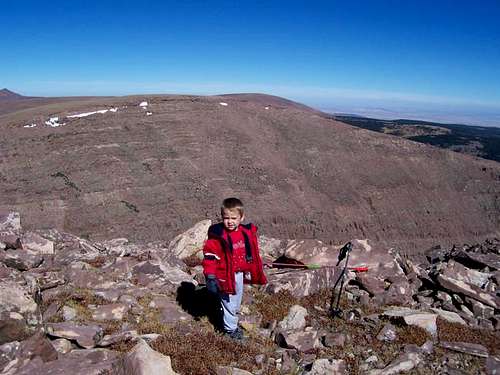
 Climbing Marsh Peak's south slope, looking north. Shortly higher than this, you must leave the trail and scramble to the summit (no trail) for the final 1000 feet.
The Paradise Park/Corral Park-West Slopes Route is described as we found it in 1994. Since this is an active logging area, it is possible that things may have changed some. This route follows the trail east to Corral Park. In 1994, the trail disappeared here, and we wasted much time looking for it. We never did find it, so consider the “trail” on the maps to be non-existent, and just use a map and compass for cross-country travel. The route continues east to the west face of Marsh Peak and climbs to the summit.
The West Ridge from Fish Lake is another variation of the route from the west.
See also the map and caption below for a detailed description of one of the possible routes up Marsh Peak from Paradise Park:
Alternate Routes
Red Tape
No permits are required. Normal wilderness rules apply.When To Climb
Mid-July through Mid-September is the normal hiking season. The roads in the area are usually open in late June or early July. They usually close when ever the first big snowstorm of the season hits, usually between mid-September and mid-October.While it is true that Marsh Peak is a short climb (one day) in summer by Uinta standards, this is not true in winter. None of the roads in the area are open in winter.
SP member Ckidd has climbed Marsh Peak in December. Below is some information.
The trip was three-and-a-half days, one-and-a-half up, one full day on the peak, and the last day back to the car. Two thirds of the distance was walked, the rest on snowshoes.
I left my '67 Mustang at the point where the Red Cloud Loop leaves Dry Fork Canyon and winds up Brownie's Canyon, I following a branch road that continues along Dry Fork Creek for several miles to the northwest before splitting again just past Massey Ranch. The northern branch -- now a much rougher road -- continues up about seven miles to Horseshoe Park, summer headquarters for a large sheep permit on the bench north of Dry Fork and south of Marsh Peak.
Following the northern branch for a couple of miles or so, there's the remnant of an old logging road that breaks to the north, switchbacks up the side of the canyon onto the bench and -- after a relatively level mile or so -- ends near Split Creek. I believe it's shown on the topo maps. The first night was spent at the end of the road, and early the following morning, very crisp and clear, I registered the lowest temperature of the trip, six degrees. The rest of the day was cross-country north roughly paralleling Split Creek across and around a certain amount of downed timber and snowshoeing across several sections of relatively deep snow. About a mile south of what I remember to be Bert Lake (from a previous ramble), I crossed Split Creek to the west and followed up a fairly steep and rocky timbered slope leading to the lower southern reaches of Marsh Peak. Second camp was at dusk a quarter mile below timberline.
The next day, December 10, was semi-overcast with high, thin clouds overhead. In planning the trip I'd been concerned about high winds above timberline, but the whole day was relatively calm. Leaving camp, I took the pack, lunch, camera and snowshoes, though the latter turned out to be unnecessary weight: most of the snow had blown off the peak and the drifts and snow fields remaining were fairly easy to negotiate.
The closer to the summit, the more I saw of the recently constructed radio relay station. “Oh my hell”, I thought, “what is this?” and soon found out. But this was the only spoiler on an absolutely exhilarating day. The views to the Uinta peaks under snow to the west, across Lakeshore Basin, and to the Wyoming plains were spectacular. I was able to see in the northern distance the southern Wind River mountains, snow-capped, which I've never done since from the vicinity. To the south the Uinta Basin (especially Ashley Valley) was under a temperature inversion and partially fog-bound. It was interesting to note that the temperatures measured at 12,200 feet during the day -- 29 through 32 degrees -- closely matched the official high for Vernal (5,330 ft. elev.) that day of 32 degrees.
Returning to camp close to dark, I packed up the next morning, the 11th, and traveling cross-country in a southeasterly direction, dropped off the ridge and onto the road near Massey Ranch and reached the car a bit after nightfall.
It was a great trip; and while not technically demanding, still was strenuous, and traveling solo a bit of a risk. But a risk worth taking and I think back to that trip with great fondness.
 Looking northeast from a snowbank just a few feet from the summit. October 1, 2005.
 Camping
If you like camping with not many restrictions, and without the crowds, this is a good place to come.Dry Fork, on the road to the east trailhead has many nice campsites in the forest, some with picnic tables and fire places. All are free of charge! There are other campsites closer to the trailhead along the road, including near the trailhead. Since the area has been logged several years ago, there is much dead wood, and you can enjoy a guilt free campfire.
The road to the west trailhead has many nice campsites as well. Paradise Park is the only official campground in the area.
There are many backcountry campsites along both routes. The only problem is that water is scarce or non existent (very rare for the Uintas!) on the eastern route after mid-or late August. The western route has many good campsites with water including Corral Park, Macks Park, and Fish Lake.
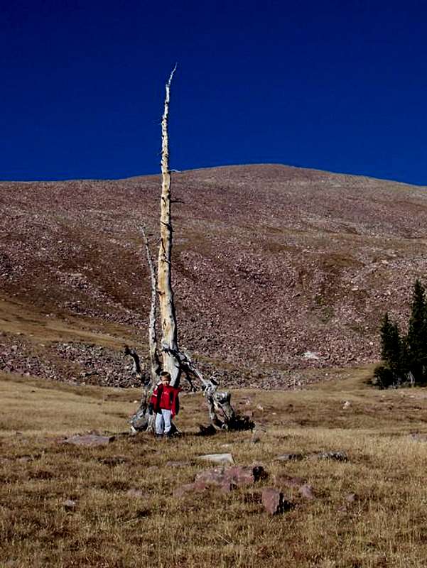 At timberline on the east slopes of Marsh Peak. The summit area can be seen in the background. Good campsites are easy to find.
Mountain Conditions
Contact the ranger station in Kamas for current road and trail conditions. Their phone number is 801-783-4338.Weather Forecast for Marsh Peak
Here are some average highs and lows from the 12,139 foot elevation (3700 meters) in the Uintas (about the same altitude as the summit):
| MONTH | HIGH | LOW |
| JAN | 14 | -1 |
| FEB | 16 | 1 |
| MAR | 19 | 4 |
| APR | 27 | 11 |
| MAY | 35 | 18 |
| JUN | 45 | 25 |
| JUL | 55 | 32 |
| AUG | 53 | 31 |
| SEP | 45 | 24 |
| OCT | 34 | 15 |
| NOV | 22 | 8 |
| DEC | 17 | 3 |