
|
|
Mountain/Rock |
|---|---|
|
|
43.10000°N / 19.00000°E |
|
|
7903 ft / 2409 m |
|
|
Overview
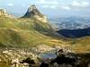
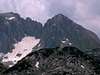
 Bandijerna from Mala Previja 2200 m pass
DURMITOR massif inlude 48 peaks which all rises up to 2000 m and 27 peaks above 2200 m. One of them is Bandijerna (2409 m), 6th highest peak of Durmitor. Bandijerna peak is placed in the heart of Durmitor, actually in E-SE part of massif. It's round and impressive rocky peak invite everyone to climb it. Bandijerna peak is surrounded by highest peaks of Durmitor. Massif of Bandijerna is closest peak to Sljeme (2455 m), Milosev Tok (2426 m), Zupci (Teeths, 2309 m) and Terzin Bogaz (2303 m). From Zupci (2309 m) Bandijerna is separate by beautiful high grassy pass called Trojni Prevoj (Tripple Pass, 2245 m), from where path continue to Bandijerna (2440 m) summit.
 Bandijerna & Trojni Prevoj pass from Minin Bogaz
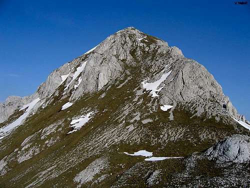 Southern side of Bandijerna from Surutka Valley
LOCATION:
Bandijerna peak is placed on E from Bobotov Kuk (2523 m), Bezimeni Vrh (2487 m), Djevojka (Soa, 2440 m), Lucin Vrh (2396 m), Planinica (2330 m), Susica Canyon, Skrka Lakes Valley and Zeleni Vir Lake (Green Vortex Lake, 2028 m), on W from Sljeme (2445 m) and Milosev Tok (2426 m), on SW from Savin Kuk, on S from Terzin Bogaz (2303 m), Medjed (2287 m) and Zabljak (1456 m) town, on NW from Uvita Greda (2200 m) and Sedlo Pass (Saddle Pass, 1907 m), on NE from Prutas (2393 m), Stit/Sareni Pasovi (Colorful Layers, 2248 m), on SE from Rbatina (2401 m), Minin Bogaz (2387 m), Obla Glava (2303 m), Crvena Greda (2175 m) and Cvorov Bogaz (2152 m).
 N-W side of Bandijerna from Lokvice Valley
SUMMIT VIEW:
W: Bobotov Kuk (2523 m), Bezimeni Vrh (2487 m), Djevojka (2440 m) and Lucin Vrh (2396 m).
E: Sljeme (2455 m), Milosev Tok (2426 m) and Savin Kuk (2303 m).
NE: Terzin Bogaz (2303 m), Medjed (2287 m) and Zabljak (1456 m) town.
SE: Uvita Greda (2200 m) and Sedlo Pass (Saddle Pass, 1907 m).
 Bandijerna W summit view to Bobotov Kuk and Bezimeni Vrh
SW: Prutas (2393 m), Stit/Sareni Pasovi (Colorful Layers, 2248 m).
NW: Rbatina (2401 m), Minin Bogaz (2387 m), Obla Glava (2303 m), Crvena Greda (2175 m) and Cvorov Bogaz (2152 m).
All of views from Bandijerna (2409 m) summit are nice, but the best are W, NW and NE. Specially W - very impressive view to Bobotov Kuk (2523 m) and Bezimeni Vrh (2487 m).
 |  |  |  |
Access & Routes Overview
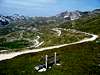
 Bandijerna from Savin Kuk
ACCESS:
 Trojni Prevoj (Tripple Pass, 2245 m) below the Bandijerna peak
Bandijerna (2409 m) summit can be reached by three routes. Usual route is southern approach from Sedlo Pass (1907 m) through Uvito Zdrijelo (2140 m) and across Trojni Prevoj (Tripple Pass, 2245 m). From Zabljak town to Sedlo Pass by car, taxi or bike. Than by walk to Bandijerna summit. Western and northern approach - by walk.
ROUTES OVERVIEW:
~Southern (Sedlo pass - 1907 m) approach:: Sedlo Pass (1907 m) - Uvito Zdrijelo (2140 m) - Suvi Tavani: marked route. Than route continue by unmarked route: Suvi Tavani - Trojni Prevoj (Tripple Pass, 2245 m) - Bandijerna (2409 m). Time: 2 h.
~Western (Skrka Valley) approach: Skrka Mountain Hut (1723 m) - Samar Pass (2075 m) - Zeleni Vir Lake (Green Vortex Lake, 2028 m): marked route. Route than continue by unmarked path: Zeleni Vir (2028 m) - Trojni Prevoj (Tripple Pass, 2245 m) - Bandijerna (2409 m). Time: 2.30 h.
~Northern (Zabljak town) approach: Crno Jezero (Black Lake, 1416 m) - Lokvice Valley (1693 m): marked route. Than by unmarked path: Lokvice Valley (1693 m) -Zelena Lokva (Green Puddle) - Suvo Lice (Dry Face) - Trojni Prevoj (Tripple Pass, 2245 m) - Bandijerna (2409 m). Time: 4.30 h.
All these routes goes to same place - Trojni Prevoj (Tripple Pass, 2245 m). From there, route continue to the summit by unmarked path. Trojni Prevoj (2245 m) - Bandijerna (2409 m): 30 min.
WATER SPRINGS:
The closest water springs to Bandijerna:
1. Spring near Zeleni Vir Lake (2028 m) (Green Vortex Lake, 2028 m), active till the end of August. 45 min from Bandijerna summit (2409 m).
2. Spring in Surutka Valley (2042 m) belowe Trojni Prevoj (Tripple Pass, 2245 m), active till the end of August. 45 min from Bandijerna summit (2409 m).
3. Spring "Studenac" on macadam road Zabljak-Virak-Sedlo-Dobri Do-Todorov Do-Trsa, near Sedlo Pass (1907 m), active from spring till winter. 2,30 h from Bandijerna summit (2409 m).
4. Spring in Dobri Do Valley (1838 m) near Sedlo Pass (1907 m), active till September. 2,15 h from Bandijerna summit (2409 m).
5. Spring in Lokvice Valley (1693 m), active till winter. 2 h from Bandijerna summit (2409 m).
 |  |  |  |
Shortly about Durmitor

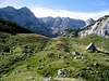
 Šljeme, Debeli Namet glacier and Bandijerna behind
DURMITOR is second highest mountain of Dinaric Alps, behind Prokletije mountain. With Slovenian Julian Alps, Prokletije and Velebit, Durmitor belong to group of most beautiful mountains of former Yugoslavia.
This beautiful mountain is situated in the north-western part of Montenegro. Durmitor National Park is surrounded by deep valleys and canyons from three side - on the N by second deepest canyon in the world and deepest in Europe - Tara river canyon, on the W by nice canyon of Piva river and Pivska Planina mountain, and on the S by Komarnica river canyon. On the E Durmitor is open to huge vast plateau (grassland) called Jezerska Povrs (Plateau of Lakes), which end is on beginning of Sinjajevina mountain. Whole national park is 39.000 hectares big.
The main features of the Durmitor region is a Jezerska Povrs vast plateau 1500 meters above sea level intersected by deep canyon gorges over towered by impressive mountain peaks - 48 of which are over 2000 m (27 over 2200 m). Highest peak of massif is Bobotov Kuk (2523 m) summit.
There are 18 glacial lakes at heights over 1500 meters adding great charm to the Durmitor massif. Also, Durmitor have 748 springs of pure mountain water and forests in which some trees are more than a few hundred years old. Along its 2000 km of climbing and hiking trails you can find many caves, such as Ledena Pechina (Ice Cave, below Obla Glava peak) and cave on Vjetrena Brda.
Among the most beautiful features of the Durmitor National Park are the sparkling waters of the rivers, carved into amazing canyon valleys. The Tara River is exceptionally beautiful, by its impressive currant, depth&landscape of the canyon, making it one of the most stunning in the world.
It is also called the "JEWEL OF EUROPE". With the length of 140 km Tara is longest river in Monte Negro. Tara river springs in Komovi mountains, near the border with Albanija, on the east of Monte Negro. It generally flows towards northwest. Its last 80 km, before it meets Piva river at Scepan Polje and they make Drina river, Tara spends in Europe’s deepest canyon, also called the "COLORADO OF EUROPE" or MONTENEGRIN COLORADO. On some places Tara canyon is 1300 m deep while below Veliki Stuoc (2104m) peak on Durmitor side of Tara’s canyon is 1600 m deep!
The natural beauty and treasures of Mt. Durmitor & the Tara river were twice awarded international confirmation. In the framework of the Project “The Biosphere and Man” the Tara River was 1977 inscribed into the ecological biosphere reservation, thus being internationally protected by internationally adopted Conventions.
Durmitorians called Durmitor mountain as "Soa Nebeska". Meaning: Durmitor peaks are so high that touch the sky - some kind of "Altar of the sky".
The Durmitor massif offers ideal conditions for mountaineering. Mountain peaks and sides were formed by withdrawing glaciers, leaving behind them moraine wrinkles and numerous lakes.
In this area, powerful tectonic forces created a mountain world adorned with extraordinary shapes.
The Durmitor National Park was in 1980 proclaimed world’s natural good and was inscribed into the Register of World’s Natural Heritage which is part of the UNESCO.
More about Durmitor on Durmitor and Bobotov Kuk pages.
 |  |
Getting There
Gateway to Durmitor National Park and Bandijerna (2409 m) peak is Zabljak (1456 m) town. Information how to get there:By Plane
~To Beograd (Belgrade, Serbia&Montenegro capital) airport. Than with plane to Podgorica, capital of Montenegro, or with bus or car to Zabljak town.
~To Podgorica airport. Than with bus or car to Zabljak town.
Information about flights find on the sites of JAT Airways, a former Yugoslav airlines, or on Montenegro Airlines.
By Bus
~Beograd (Belgrade)-Zabljak
~Podgorica-Zabljak
~Niksic-Zabljak
~Pljevlja-Zabljak
Buses go to Zabljak from Beograd (Belgrade) twice a day and from Podgorica, Niksic, Pljevlja and Mojkovac several times per day.
By Car
~Beograd (Belgrade)-Zlatibor-Nova Varos-Prijepolje-Pljevlja-Zabljak
~Niksic - Savnik (47km) - Zabljak (37km): 84km; Niksic to Zabljak approach from south.
~Niksic - Savnik (35km) - Zabljak (37km): 72km;
~Podgorica - Niksic (55 km)-Savnik (47 km)-Zabljak (37 km): 139 km; Add this length if you are going to Zabljak from Podgorica via Niksic. Road to Niksic from Podgorica is good.
~Podgorica - Kolasin (71km) - Mojkovac (21km) - Zabljak (67km): 159km; road is good all the way to Zabljak. Behind Podgorica (56m) you go inside Moraca River canyon (one of spectacular Montenegrin canyons). It is up to 1000m deep and has wild sides. That's spectacular drive. After that, from "Djurdjevica Tara" bridge to Zabljak - 23 km.
 |  |
When To Climb
In Mt Durmitor you can climb during all year seasons, but ideal period for climbing is mid June - mid September. But, you can also climb with crampons and other equipment during winter-spring period (March-June). Bandijerna is very attractive peak for climbing in this period.During the winter, Durmitor usually switches into ski resort. Under Savin Kuk peak (2313 m) is Durmitor Ski Center. (gondolas, ski lifts, chair lifts, restorants and their customers).
Crno Jezero (Black Lake, 1416 m) and Dobri Do (Sedlo Pass, 1907 m) locations are a common climbing starting point. All major trails further uphill are well marked with white circle/red border marks.
Whole Durmitor mountain is very good marked. Thanks to Branislav Cerovic, greatest knower and devoter of Durmitor National Park, who marked all routes on Durmitor mountain.
 |  |
Camping
Camping permitted on camping dedicated spots only.Major huts are in good condition, but with no service. Still, open to the general public. Hikers/climbers are supposed to bring all the jummy stuff with them.
On Durmitor exist camps in Ivan Do and Razvrsje, and few mountain huts and bivouacs:
~Hut with few small shepherd's houses in Lokvice valley
~Hut in Skrka Lakes valley (you can sleep and buy the food)
~Bivouac in Velika Kalica valley
~Hut "Mushova koliba" on the road from Zabljak to Obla Glava (2303 m) peak, near Ledena Pechina (Ice Cave) - empty simply hut from wood, without service, simple conditions...
~In Ivan Do camp price for camping is 4 Euro per day.
Also, in Zabljak town you can rent private room or apartment. Price for 2-beds apartment with kitchen and bathroom: 10-12 Euro (5-6 Euro per person).
In some villages on mountain, for example in Bosaca village, you can rent a 2-beds apartment for price 6-8 Euro (3-4 Euro per person) with free milk products every day (1 liter of caw milk).
 |
Mountain Conditions
The best weather forecast on Internet for Durmitor (Zabljak town) is VREME YUBC NET site. You can see 5 days forecast for Durmitor area, 4-times-daily forecast.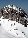 |
Maps
Exist three maps of Durmitor:1. Map of Durmitor Massif & Tara Canyon - 1:25000. Author: Branislav Cerovic. You can buy it in Zabljak town in almost every store. Price: 5-6 euro.
2. Map of Durmitor National Park & Tara Canyon - 1:25000. Author: Branislav Cerovic. You can buy it in Beograd (Belgrade, Serbia) in Geokarta Co, Belgrade. Price: 2 euro. This map is better than first one and include many informations and facts about routes, peaks, lakes, glacial cirques, valleys, canyons,...
3. Durmitor Mountain Guide & Map. Short mountain guide with some basic informations and facts. Author of map: Pavle S. Bandovic. Editor: "Summit" Travel Agency, Zabljak, 2005. Price of Guide&Map: 7 euro.
 |  |
Red Tape
No fees or extra fees for entering the National Park.No permits needed either.
Usual rules of behaviour for NP's do apply.
 |