
|
|
Mountain/Rock |
|---|---|
|
|
46.37794°N / 13.83677°E |
|
|
Hiking, Mountaineering, Sport Climbing, Ice Climbing, Big Wall, Via Ferrata |
|
|
Spring, Summer, Fall, Winter |
|
|
9395 ft / 2864 m |
|
|
About Triglav
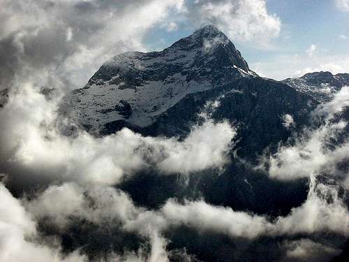
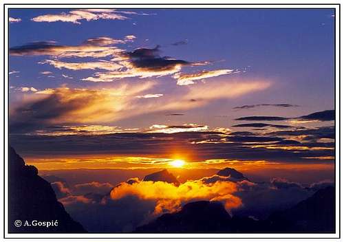
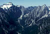
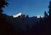
Triglav (2864m) and its monumental North Face above Vrata Valley
Triglav is not just a mountain, Triglav is kingdom, wrote Julius Kugy, famous explorer of Julian Alps, in his book Aus dem Leben eines Bergsteiger (From the Life of the Mountaineer), after the WWI. He couldn’t be more right. Silhouette of Slovenian sacred mountain and nation’s highest peak proudly stands on national flag as national coat of arms. Triglav does not only have an appeal on its people, it is truly an international giant as people from all over the world pilgrimage to its kingdom. Germans also address it as König Triglav. It is certainly one of the most desired and climbed mountains of whole Alps! First president of Slovenia, Milan Kucan, said that it is obligation of every Slovenian to climb Triglav once at least.
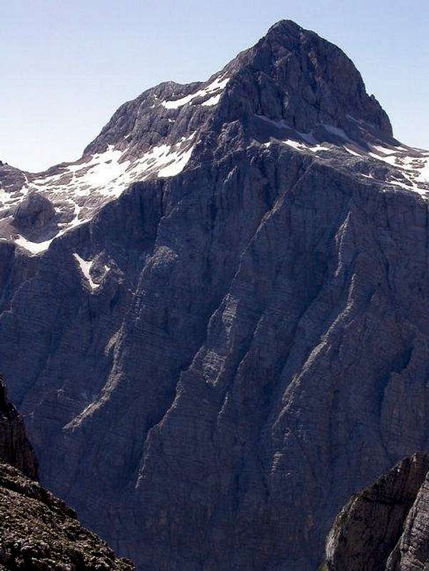
The facts. Triglav (2864m) is highest peak of Julian Alps and Slovenia. ‘He’ is the true ruler of closer and wider surroundings. Nothing challenges it, as it is considerably higher than other high Julian Alps peaks. Closest higher peak is Reißeck in Austria, some 90km away. From anywhere you look it dominates, there is no doubt who is No1. Superlatives used to describe it are certainly justified. Beauty of this region is unique and that was the reason to declare whole Julian Alps to be huge Triglav National Park.
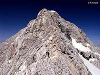
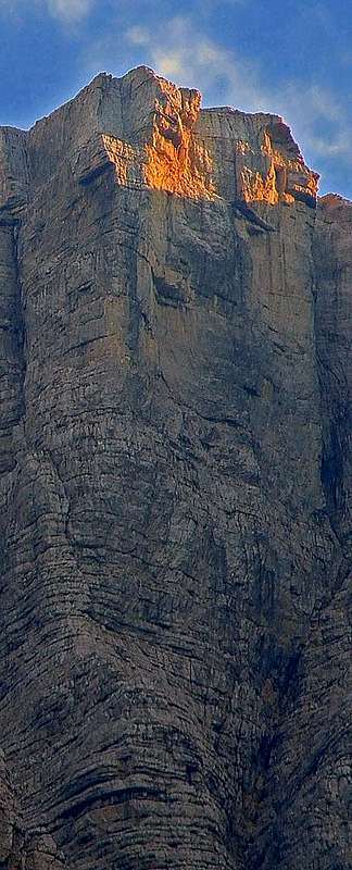
Triglav summit
Triglav rises very high above its foothills. From all sides it is surrounded with deep valleys. It is like they are supporting high pedestal on which The King sits. And that pedestal is something like high lying plateau on which the main body of peak stands. On the N is Vrata valley, probably the most beautiful in Slovenia. Above it Triglav rises almost 2km and shows its most powerful side, the magnificent Stena or The Face. It is over 1km high and 3km wide (more below). On the other side of the valley, towards north, is Skrlatica (2740m) and its group. Towards NW the edge of the Face gradually descends till Luknja pass (1758m), which connects Triglav with Prisojnik - Razor group. On the W, slopes of Triglav are steep and high, they descent 2km into the Zadnjica valley, this is subsidiary to Trenta valley. On the SW first neighbour of Triglav is Kanjavec (2568m) from which it is separated by Dolic pass (2164m). On the S is, around 1000m lower, Velska Dolina valley and Velo Polje field. These slopes, although high and quite wild, are much more subdued when comparing to western and northern ones. On the SE is Konjsko Sedlo pass (2020m), over which Triglav is connected with Tosc (2275m) and its group. On the E is long and deep Krma valley, while on the NE is Kot valley. Bottoms of both valleys are 2km lower than Triglav. Between them is wild ridge and group of peaks with impressive sides above both valleys. Highest of them is Rjavina (2532m). At the NE foothills of summit pyramid is Zeleni Sneg. It used to be glacier, the only one in Julian Alps. Sadly, global warming reduced it to large snowfield.
Name. The origin of Triglav name is still not completely clear. People used to be believe that it is home of Gods. Triglav means three heads (tri glave). Although mountain is compact, from south it shows 3 heads. On the left is Rjavec (2568m), in the middle is main summit, Triglav (2864m) and on the right is Mali Triglav (2725m, small Triglav), which is actually just a shoulder, not a real peak, like what is Monte Bianco di Courmayer to Mont Blanc.
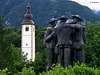
Stirje Srcni Mozje
History. First on the summit where: Luka Korosec, Matija Kos, Stefan Rozic and Lovrenc Willomitzer. It happened on August 25th 1778. They climbed from Bohinj lake, over Velo Polje (where today is Vodnikov Dom hut), then to Ledine (where today is Planika hut) and further to Mali Triglav. Behind it, then notorious, ridge awaited them. They had to ride it because it is so narrow and on both sides is few hundred meters of sheer drop. Triglav was one of first important alpine peaks that were climbed. It was great feat for that time. First ascent from Krma valley happened in 1818.
Important year in history
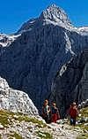
Today Triglav is by far mostly climbed high peak in Slovenia and wider. Last 108 years, on the summit proudly stands Aljazev Stolp (more in objects section). Just below the summit is Stanicevo Zavetisce refuge, carved in stone. Four secured routes lead to Triglav. Some say that Triglav was humiliated with all that steel on the mountain. It became easy for anyone in better shape to climb Triglav, so today crowds can sometimes be unbearable and you have to wait on the ropes for long lines of people to pass as so many want to climb this magical mountain. Triglav regains respect in winter when security pegs and steel ropes are covered with snow. Then it is reserved only for experienced mountaineers and climbers. There are many huts around Triglav. In summer they are often overcrowded.
 |
 |
 |
 |
 |
 |
 |
 |
 |
 |
 |
 |
 |
 |
 |
 |
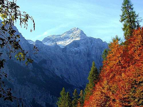
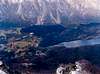
Triglav from Distance
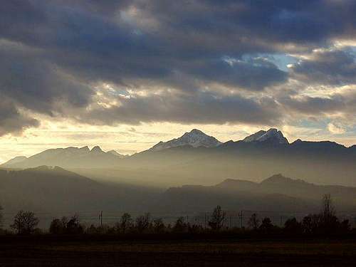 Triglav from Sava river plains
 |
 |
 |
 |
 |
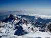
Triglav View
View from Triglav is absolutely amazing! Triglav perhaps has one of the widest views in entire Alps, which stretches few hundred kilometres in all directions. It is because Triglav is so dominant that nothing obscures the panorama and even more so because of its position. Julian Alps are on the SE edge of the Alps, on the border of 3 great regions: The Alps, Adriatic Sea and central European lowlands, so the view is very diverse. In the panorama there are green plains and hills, blue sea and usual sea of Alpine peaks while from most of Alpine peaks all you get is sea of other peaks. Here is view description.
 NW: behind the hole that is Luknja pass (1758m) are Pihavec (2414m) and Bovski Gamsovec (2392m). Behind them long and sharp ridge rises from Trenta valley which is on the left end of this panorama direction. Little bit left of Pihavec is Golicica (2101m), then comes wide Planja (2453m) with several towers and finally one of Julian Alps greats Razor (2601m). Behind Golicica is larger space (basin) of upper Trenta valley. Above it proudly stands sharp Jalovec (2645m). Just right of it is another great of Julian Alps, a close friend of Jalovec, Mangart (2678m). In front of it and right of Jalovec long ridge of Travnik (2379m) and Mojstrovka (2366m) stretches. Right of it and behind the pass between Planja and Razor mighty Prisojnik (2547m) sticks. Further behind Julian Alps is sea of Austrian Alps. Horizon is closed by Hohe Tauern. Among many peaks there Grossvenediger (3666m) and Grossglockner (3798m) are especially worthy of mentioning. NW: behind the hole that is Luknja pass (1758m) are Pihavec (2414m) and Bovski Gamsovec (2392m). Behind them long and sharp ridge rises from Trenta valley which is on the left end of this panorama direction. Little bit left of Pihavec is Golicica (2101m), then comes wide Planja (2453m) with several towers and finally one of Julian Alps greats Razor (2601m). Behind Golicica is larger space (basin) of upper Trenta valley. Above it proudly stands sharp Jalovec (2645m). Just right of it is another great of Julian Alps, a close friend of Jalovec, Mangart (2678m). In front of it and right of Jalovec long ridge of Travnik (2379m) and Mojstrovka (2366m) stretches. Right of it and behind the pass between Planja and Razor mighty Prisojnik (2547m) sticks. Further behind Julian Alps is sea of Austrian Alps. Horizon is closed by Hohe Tauern. Among many peaks there Grossvenediger (3666m) and Grossglockner (3798m) are especially worthy of mentioning. |
---------------------------------------------------------------------------------------------
 N: below is huge abyss of Vrata valley, whose bottom is almost 2000m lower. If you look carefully you’ll recognize Aljazev Dom hut. On the other side of Vrata Skrlatica group towers towards sky. From left lined up are: Stenar (2501m), Dolkova Spica (2591m), Skrlatica (2740m), Rokav (2646m), Oltar (2621m), Dovski Kriz (2542m) and Kukova Spica (2421). Behind the sharp peaks of the group are many lower and higher Austrian mountains. Behind Stenar is Villacher Alpe (2166m), easily recognizable with TV tower on the summit. Further behind are Ankogel (3246m) and Hochalmspitze (3360m) in Hohe Tauern. N: below is huge abyss of Vrata valley, whose bottom is almost 2000m lower. If you look carefully you’ll recognize Aljazev Dom hut. On the other side of Vrata Skrlatica group towers towards sky. From left lined up are: Stenar (2501m), Dolkova Spica (2591m), Skrlatica (2740m), Rokav (2646m), Oltar (2621m), Dovski Kriz (2542m) and Kukova Spica (2421). Behind the sharp peaks of the group are many lower and higher Austrian mountains. Behind Stenar is Villacher Alpe (2166m), easily recognizable with TV tower on the summit. Further behind are Ankogel (3246m) and Hochalmspitze (3360m) in Hohe Tauern. |
---------------------------------------------------------------------------------------------
 NE: below Triglav is large undulating high rocky plateau. On the left it falls towards Vrata valley. Little bit behind above Vrata are Begunjski Vrh (2461m) and Cmir. Their northern faces fall wildly towards Vrata. Right of Begunjski Vrh, at the edge of plateau, is Vrbanova Spica (2408m), while right of it, on the plateau, stands Staniceva Koca hut (2332m). Right of Vrbanova Spica is sharp and mighty Rjavina (2532m). Between them is upper end of steep Kot valley. Behind hole of the Kot valley is forested ridge of Mezakla (1593m). In front of Rjavina and right above plateau is Rz (2538m)-Kredarica (2541m) ridge. On the small plateau near the summit of Kredarica stands Kredarica hut (2515m), highest and largest in Slovenia. Behind Julian Alps and upper Sava river valley is western part of Karavanke Alps which are border between Slovenia and Austria. Behind them is sea of Austrian Alps. NE: below Triglav is large undulating high rocky plateau. On the left it falls towards Vrata valley. Little bit behind above Vrata are Begunjski Vrh (2461m) and Cmir. Their northern faces fall wildly towards Vrata. Right of Begunjski Vrh, at the edge of plateau, is Vrbanova Spica (2408m), while right of it, on the plateau, stands Staniceva Koca hut (2332m). Right of Vrbanova Spica is sharp and mighty Rjavina (2532m). Between them is upper end of steep Kot valley. Behind hole of the Kot valley is forested ridge of Mezakla (1593m). In front of Rjavina and right above plateau is Rz (2538m)-Kredarica (2541m) ridge. On the small plateau near the summit of Kredarica stands Kredarica hut (2515m), highest and largest in Slovenia. Behind Julian Alps and upper Sava river valley is western part of Karavanke Alps which are border between Slovenia and Austria. Behind them is sea of Austrian Alps. |
---------------------------------------------------------------------------------------------
E: right of Rjavina, Rz and Kredarica is deep and long Krma valley. On its other side is impressive uninterrupted north wall above which many peaks rise. On the left is Debela Pec (2014m) while on the right end is trio of beautiful peaks: Mali Draski Vrh (2131m), Veliki Draski Vrh (2243m) and Tosc (2275m), already on SE. Behind the wall and all of these peaks is large forested Pokljuka plateau. On the left, behind Pokljuka is large plain around Sava valley. Many villages are on it which are during the night lit by thousands of lights. Further behind are Karavanke Alps with their highest peak Stol (2236m). Right of Stol Kamnik Alps begin while Karavanke continue behind them (left). Kamnik Alps are quite high and easily recognizable. Most eminent are: Grintovec (2558m)
Kocna (2540m) and Storzic (2132m).
---------------------------------------------------------------------------------------------
SE: already mentioned Veliki Draski Vrh and Tosc, both above Krma valley, are on SE. Behind them is part of Pokljuka plateau. Further back is Bohinj valley and lower SE Julian Alps behind. Among the peaks of that area Ratitovec (1667m) is worthy mentioning. Further back is central Slovenian plain where capital Ljubljana is placed. Behind are central Slovenian hills.
---------------------------------------------------------------------------------------------
 S: below Triglav is rocky plateau Ledine where Planika hut (2401m) stands. Behind Ledine Triglav pedestal descends into large basin of Velo Polje. Left above it, on the slopes of bulky Tosc, you can recognize Vodnikov Dom hut (1817m). Behind Velo Polje is Voje valley which flows into Bohinj Lake basin. Right of Velo Polje is Velska Dolina valley, closed from the other side by the north wall of Miselj Vrh (2350m) – Miseljski Konec (2464m) ridge. Behind their long ridge is group of upper Bohinj peaks. From left most notable are Stog (2040m), Ogradi (2087m), Skednjovec (2309m) and large Debeli Vrh (2392m). Behind these peaks is forested plateau above large Bohinj Lake basin. At the edge most eminent is Prsivec (1761m). Behind Bohinj lake basin is long streak of peaks lined up in South Bohinj group. Group is southern edge of the Julian Alps and Alps in general, at this spot. Behind it is wide undulating area of Slovenian karst. On its southern end stands the cone of Slovenski Sneznik (1796m). On the clearest of day just right of Sneznik Velebit in Croatia is visible. S: below Triglav is rocky plateau Ledine where Planika hut (2401m) stands. Behind Ledine Triglav pedestal descends into large basin of Velo Polje. Left above it, on the slopes of bulky Tosc, you can recognize Vodnikov Dom hut (1817m). Behind Velo Polje is Voje valley which flows into Bohinj Lake basin. Right of Velo Polje is Velska Dolina valley, closed from the other side by the north wall of Miselj Vrh (2350m) – Miseljski Konec (2464m) ridge. Behind their long ridge is group of upper Bohinj peaks. From left most notable are Stog (2040m), Ogradi (2087m), Skednjovec (2309m) and large Debeli Vrh (2392m). Behind these peaks is forested plateau above large Bohinj Lake basin. At the edge most eminent is Prsivec (1761m). Behind Bohinj lake basin is long streak of peaks lined up in South Bohinj group. Group is southern edge of the Julian Alps and Alps in general, at this spot. Behind it is wide undulating area of Slovenian karst. On its southern end stands the cone of Slovenski Sneznik (1796m). On the clearest of day just right of Sneznik Velebit in Croatia is visible. |
---------------------------------------------------------------------------------------------
<t
</t
 |
 |
 |
 |
 |
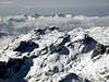
Kredarica View
 Evening in the Kingdom of Triglav
Not only Triglav offers immense panoramas upon its kingdom. Because Triglav is tough bite for one day most of the people sleep over in one of Triglav huts. Among them 3 are high lying: Stanicev Dom hut (2332m), Planika (2401m) and Kredarica (2515m). All of them have beautiful views but the one from Slovenian highest hut, Kredarica, is amazing! If you are going to spend the night in the neighborhood of Triglav do it on Kredarica. Yes, it is most overcrowded of all but the panorama it offers is worth the night spent on the floor or table :-) Yes, mattresses are given.
 |
 |
 |
 |
 |
 |
 |
 |
 |
 |
 |
 |
 |
 |
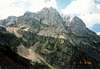
Stena (The Face)
Sfinga (The Sphynx)
Triglav and its Stena
Triglav and its North Face
North face of Triglav is most impressive in Julian Alps and Slovenia. 1200m high and around 3km wide face belongs to the alpine elite. Its name is written into the foundations of European alpinism. In the face there are numerous couloirs, towers or pillars, which divide it into few sections. In the eastern part most noticeable are Slovenian and German Steber towers. Most powerful is Centralni Steber, as name says, in the central part, which is steepest. In the western section is wild and high Jugova Grapa couloir. Above it is best known part of the face, Sfinga, almost smooth overhanging section.
First man to climb The Face was Berginc, a hunter from Trenta valley, in 1890. He climbed where today is Slovenska Smer, famous route suitable for experienced mountaineers that have some knowledge in climbing (up to III grade). First to climb central part were German climbers König, Reinl and Domenigg in 1906. Since then many routes were climbed in the face. The most famous route is Copov Steber, climbed in 1945 by Joza Cop and Pavla Jesih. The face is much climbed and represents to climbers what Triglav is to mountaineers.
Here are few routes:
Slovenska Smer route
Nemska Smer (German route)
Zimmer - Jahn exit (variation of German route): 800m, IV+
Bavarska Smer (Bavarian route): IV
Skalaska Smer route: IV-V
Copov Steber (Chop pillar) route: 1000m, VIII+
Prusik-Szalay and Kunaver-Drasler routes: 900m, VII+
Stopnice v Nebo (Stairs to the Sky): 500m, VI+
Zlatorogove Police (Zlatorog ledges)
Best view of Stena is from the Aljazev Dom hut and further up the valley and especially from the routes leading towards Pogacnikov Dom hut via Sovatna or Bovski Gamsovec (2392m).
 |
 |
 |
 |
 |
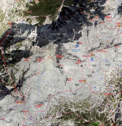
Valleys
Starting points of all Triglav routes are in beautiful valleys that cut into the Triglav kingdom. Here is brief description of the valleys.
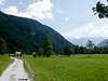
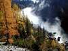
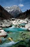
 VRATA, the most famous of Triglav valleys, is the most beautiful in Slovenia. Although there are many other beautiful valleys most would agree that Vrata is THE one. Many songs and books have been written about it. Maybe few are not familiar with famous Triglav panorama, which decorates many postcards, books and posters. It is largest, deepest and longest (11km) of three northern Triglav valleys. Road enters it from Mojstrana, picturesque village in the upper Savska Dolina valley. You are driving or walking through nice mixed forest of beech, spruce and fir, along the crystal clear Triglavska Bistrica creek. Sides above valley raise fast, especially the right side, which literally rush to the sky. That is Skrlatica group. On the left are more moderate forested slopes of the ridge that divides Vrata from Kot valley. After few kilometres on the right is beautiful Pericnik waterfall, which you should not miss to visit. As you get deeper into valley left side becomes wild to, cliffs of Cmir (2393m) and Begunjski Vrh (2461m) rise high above the valley. Occasionally you get views of Skrlatica group and its wild slopes below the peaks of Kukova Spica (2427m), Dovski Kriz (2542m), Oltar (2621m), Rokavi (2646m), Skrlatica (2740m) and Dolkova Spica (2591m). In front of you is massive Stenar (2501m), which attracts view early down the valley. After a while huge wall appears through and above the forest. You can’t take your eyes of it. In front of you is Triglav and its mighty north face or, Stena. Sight can easily go in the books as one of THE panoramas of the Alps! After 12km you are at Aljazev Dom hut. From here you can admire the grandeur of 1200m high and more than 3km wide Face and Triglav, wild Dolkova Spica and Skrlatica, high cliffs of Stenar, which are so close you can almost touch them. Even better view is just 5 minutes up the valley, from the monument to fallen Partisans who fought in the mountains, which is giant peg. Lowest of surrounding peaks is 1.4km above valley floor while Triglav rises almost 2km! VRATA, the most famous of Triglav valleys, is the most beautiful in Slovenia. Although there are many other beautiful valleys most would agree that Vrata is THE one. Many songs and books have been written about it. Maybe few are not familiar with famous Triglav panorama, which decorates many postcards, books and posters. It is largest, deepest and longest (11km) of three northern Triglav valleys. Road enters it from Mojstrana, picturesque village in the upper Savska Dolina valley. You are driving or walking through nice mixed forest of beech, spruce and fir, along the crystal clear Triglavska Bistrica creek. Sides above valley raise fast, especially the right side, which literally rush to the sky. That is Skrlatica group. On the left are more moderate forested slopes of the ridge that divides Vrata from Kot valley. After few kilometres on the right is beautiful Pericnik waterfall, which you should not miss to visit. As you get deeper into valley left side becomes wild to, cliffs of Cmir (2393m) and Begunjski Vrh (2461m) rise high above the valley. Occasionally you get views of Skrlatica group and its wild slopes below the peaks of Kukova Spica (2427m), Dovski Kriz (2542m), Oltar (2621m), Rokavi (2646m), Skrlatica (2740m) and Dolkova Spica (2591m). In front of you is massive Stenar (2501m), which attracts view early down the valley. After a while huge wall appears through and above the forest. You can’t take your eyes of it. In front of you is Triglav and its mighty north face or, Stena. Sight can easily go in the books as one of THE panoramas of the Alps! After 12km you are at Aljazev Dom hut. From here you can admire the grandeur of 1200m high and more than 3km wide Face and Triglav, wild Dolkova Spica and Skrlatica, high cliffs of Stenar, which are so close you can almost touch them. Even better view is just 5 minutes up the valley, from the monument to fallen Partisans who fought in the mountains, which is giant peg. Lowest of surrounding peaks is 1.4km above valley floor while Triglav rises almost 2km!Vrata valley attracts many visitors. It is great base for various activities, equally interesting for mountaineers, climbers, tour skiers or tourists who just come to admire magnificent Face and Triglav. Three different routes lead towards Triglav from Vrata: Tominskova Pot, Pot Cez Prag and Bambergova Pot. All of them are tough and long secured climbing routes but certainly most attractive way to climb Triglav. |
 |
---------------------------------------------------------------------------------------------------------------------------------
 KOT valley is eastern neighbour of Vrata, middle valley of three northern Triglav valleys and shortest (7km) among them. It is also accessible by car from Mojstrana but also from Bled. Bottom of the valley is under the forest whose upper line is at around 1300m. Lower half is gradually ascending and is surrounded by forested slopes from west and east. Road reaches 1000m. Upper half of the valley is steep slope, covered with scree. Left (south-eastern) side is huge and wild wall, made of amazing cliffs of Dimniki (2104m), Luknja Pec (2249m) and especially Rjavina (2532m), whose face is 800m high. On the right, western side, are cliffs of sharp ridge which connects Spodnja Vrbanova Spica (2299m) with Visoka Vrbanova Spica (2408m). Last part of the valley, squeezed between the cliffs, is scree basin called Pekel (Hell). On the upper edge of it stands Dom Valentina Stanica hut (2332m). KOT valley is eastern neighbour of Vrata, middle valley of three northern Triglav valleys and shortest (7km) among them. It is also accessible by car from Mojstrana but also from Bled. Bottom of the valley is under the forest whose upper line is at around 1300m. Lower half is gradually ascending and is surrounded by forested slopes from west and east. Road reaches 1000m. Upper half of the valley is steep slope, covered with scree. Left (south-eastern) side is huge and wild wall, made of amazing cliffs of Dimniki (2104m), Luknja Pec (2249m) and especially Rjavina (2532m), whose face is 800m high. On the right, western side, are cliffs of sharp ridge which connects Spodnja Vrbanova Spica (2299m) with Visoka Vrbanova Spica (2408m). Last part of the valley, squeezed between the cliffs, is scree basin called Pekel (Hell). On the upper edge of it stands Dom Valentina Stanica hut (2332m).Trail through Kot is considered to be one of the shortest Triglav approaches but valley is very lonely. The least number of people ascend through it. |
---------------------------------------------------------------------------------------------------------------------------------
 KRMA valley is eastern neighbour of Kot and second longest (10km) among three northern Triglav valleys. Sides above the valley are wild, steep and high. Eastern side is long and high wall, made of cliffs of Debela Pec (2014m), Lipanski vrh (1975m), Debeli Vrh (1962m), Mali Draski Vrh (2123m), Veliki Draski Vrh (2243m) and Tosc (2275m). To climbers most interesting is Veliki Draski Vrh, whose cliffs are 700m high. Western side is even higher and wilder, made of Macesnovec (1926m), Dimniki (2104m), Luknja Pec (2249) and mighty Rjavina (2532m), which rises more then 1.5km above the valley floor. End of the valley is closed by Vernar (2225m). Bottom is almost flat, very gradually rising. At the entrance are large Spodnja Krma meadows with few houses and farms. Somewhere before the mid part of the valley is Zasipska Planina, another large meadow. Here stands Kovinarska Koca hut. Road which approaches from Mojstrana or Bled ends at altitude of 950m. Mostly beech forest disappears around 1250m as valley is squeezed between high cliffs and scree slopes. There is lot of dwarf pine in the upper part and also many lonely larch trees. Both Kot and Krma are dry valleys without constant water flow. KRMA valley is eastern neighbour of Kot and second longest (10km) among three northern Triglav valleys. Sides above the valley are wild, steep and high. Eastern side is long and high wall, made of cliffs of Debela Pec (2014m), Lipanski vrh (1975m), Debeli Vrh (1962m), Mali Draski Vrh (2123m), Veliki Draski Vrh (2243m) and Tosc (2275m). To climbers most interesting is Veliki Draski Vrh, whose cliffs are 700m high. Western side is even higher and wilder, made of Macesnovec (1926m), Dimniki (2104m), Luknja Pec (2249) and mighty Rjavina (2532m), which rises more then 1.5km above the valley floor. End of the valley is closed by Vernar (2225m). Bottom is almost flat, very gradually rising. At the entrance are large Spodnja Krma meadows with few houses and farms. Somewhere before the mid part of the valley is Zasipska Planina, another large meadow. Here stands Kovinarska Koca hut. Road which approaches from Mojstrana or Bled ends at altitude of 950m. Mostly beech forest disappears around 1250m as valley is squeezed between high cliffs and scree slopes. There is lot of dwarf pine in the upper part and also many lonely larch trees. Both Kot and Krma are dry valleys without constant water flow.Triglav ascent through Krma is long but technically easy which makes it best winter route. It is very popular among tour skiers because of very long and quite moderate descent from Kredarica hut (2515m) that has altitude difference of 1700m. |
 |
 |
 |
---------------------------------------------------------------------------------------------------------------------------------
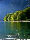
 BOHINJ is upper part of 20km long Sava Bohinjka river valley. It is beautiful glacial valley where river comes to life as Savica and immediately creates largest Slovenian lake, Bohinjsko Jezero. This is one of most visited spots of Julian Alps. Lake is at the altitude of 525m, it is almost 5km long and around 1km wide, up to 45m deep. In summer is great place to swim and refresh when you descent from surrounding mountains. North of the lake are high and very steep sides, which are rising from east towards west, and in Prsivec (1761m) they culminate. These slopes are mixture of grass and cliffs with some larch trees. South of the lake are also steep slopes of South Bohinj Ridge. Cliffs rise above short forested section. On the upper edge stands Vogel Ski hotel (1537m). Very attractive Cable car ascends from the lake to hotel, which is fantastic view point towards southern side of Triglav group and Triglav. On the west valley ends glacial cirque, below the cliffs of Komarca. In these cliffs is source of Savica river, which just few meters behind cave source falls, creating beautiful and well known, 40m high, Savica waterfall. Road winds along the southern shores of the lake, ending at Koca pri Savici hut (653m), which is 15 minutes below the waterfall. Water leaves the lake, creating Sava Bohinjka river, at Ribcev Laz village, on the eastern shores of the lake. Just by the bridge, below which water leaves the lake, is famous Sveti Janez church from 15th century. Also near the bridge is monument to Stirje Srcnim Mozem (4 brave men) who first climbed Triglav on August 26th 1778. BOHINJ is upper part of 20km long Sava Bohinjka river valley. It is beautiful glacial valley where river comes to life as Savica and immediately creates largest Slovenian lake, Bohinjsko Jezero. This is one of most visited spots of Julian Alps. Lake is at the altitude of 525m, it is almost 5km long and around 1km wide, up to 45m deep. In summer is great place to swim and refresh when you descent from surrounding mountains. North of the lake are high and very steep sides, which are rising from east towards west, and in Prsivec (1761m) they culminate. These slopes are mixture of grass and cliffs with some larch trees. South of the lake are also steep slopes of South Bohinj Ridge. Cliffs rise above short forested section. On the upper edge stands Vogel Ski hotel (1537m). Very attractive Cable car ascends from the lake to hotel, which is fantastic view point towards southern side of Triglav group and Triglav. On the west valley ends glacial cirque, below the cliffs of Komarca. In these cliffs is source of Savica river, which just few meters behind cave source falls, creating beautiful and well known, 40m high, Savica waterfall. Road winds along the southern shores of the lake, ending at Koca pri Savici hut (653m), which is 15 minutes below the waterfall. Water leaves the lake, creating Sava Bohinjka river, at Ribcev Laz village, on the eastern shores of the lake. Just by the bridge, below which water leaves the lake, is famous Sveti Janez church from 15th century. Also near the bridge is monument to Stirje Srcnim Mozem (4 brave men) who first climbed Triglav on August 26th 1778.From Bohinj there are two main directions to climb Triglav. One ascends from Savica hut, over Komarca and further goes through 7 Triglav lakes valley. Other ascends over Velo Polje and Vodnikov Dom hut. Till Velo Polje there are two variations. One goes through Voje valley and the other over Uskovnica pastures. |
 |
---------------------------------------------------------------------------------------------------------------------------------
 VOJE is glacial valley, subsidiary to Bohinj (north of Bohinj). On the east and west are steep forested sides. Western are much higher. Above the eastern slopes are Uskovnica pastures. On the north valley is closed by mighty Tosc (2275m), which rises 1.5km above it. Left of Tosc is forested edge of Velo Polje field (around 1800m). In the mid part of the valley are flat and beautiful pastures, almost 3km long. At the southern edge of the meadows stands the Planinska Koca Bohinjskih Prvoborcev (690m) hut. Through the valley flows Mostnica river. Its source is high (around 1350m) on the slopes of Tosc. From the hut, till it leaves Voje valley, near the Stara Fuzina village in Bohinj valley, Mostnica carved amazing gorge. It is not very deep (up to 40m) but amazingly narrow, with smooth sides. This is well known spot to visit in Bohinj area. Path runs along the gorge, with few bridges and numerous view points into the gorge through which crystal clear river of emerald color flows. Near the end of the gorge is famous Hudicev Most Bridge. VOJE is glacial valley, subsidiary to Bohinj (north of Bohinj). On the east and west are steep forested sides. Western are much higher. Above the eastern slopes are Uskovnica pastures. On the north valley is closed by mighty Tosc (2275m), which rises 1.5km above it. Left of Tosc is forested edge of Velo Polje field (around 1800m). In the mid part of the valley are flat and beautiful pastures, almost 3km long. At the southern edge of the meadows stands the Planinska Koca Bohinjskih Prvoborcev (690m) hut. Through the valley flows Mostnica river. Its source is high (around 1350m) on the slopes of Tosc. From the hut, till it leaves Voje valley, near the Stara Fuzina village in Bohinj valley, Mostnica carved amazing gorge. It is not very deep (up to 40m) but amazingly narrow, with smooth sides. This is well known spot to visit in Bohinj area. Path runs along the gorge, with few bridges and numerous view points into the gorge through which crystal clear river of emerald color flows. Near the end of the gorge is famous Hudicev Most Bridge. |
---------------------------------------------------------------------------------------------------------------------------------
 ZADNJICA is quite short (3.5km) subsidiary to famous Trenta valley. It begins at Trenta village and opens towards east. It gradually rises till its end at Planja (1000m). Bottom is mostly forested and there are few meadows. Around the valley is some of the most dramatic scenery in Julian Alps. The cliffs of Pihavec (2414m), Triglav (2864m), Kanjavec (2568m), Vrsac (2194m) and Ozebnik (2083m), which fall into dark depths of Zadnjica have no match in Julian Alps. They create amazing wall around the valley, which culminates with highest face of Julian Alps, that of Kanjavec, which is 1500m high! In the valley is dark and subdued atmosphere because walls around are letting very little sunshine in. End of valley is reached by road, which is closed to traffic 2km above the Trenta village. From the valley there are two possibilities to climb Triglav. One will take you via Dolic pass and hut while the other ascends towards Luknja pass where it joins Bambergov Pot trail from Vrata valley. ZADNJICA is quite short (3.5km) subsidiary to famous Trenta valley. It begins at Trenta village and opens towards east. It gradually rises till its end at Planja (1000m). Bottom is mostly forested and there are few meadows. Around the valley is some of the most dramatic scenery in Julian Alps. The cliffs of Pihavec (2414m), Triglav (2864m), Kanjavec (2568m), Vrsac (2194m) and Ozebnik (2083m), which fall into dark depths of Zadnjica have no match in Julian Alps. They create amazing wall around the valley, which culminates with highest face of Julian Alps, that of Kanjavec, which is 1500m high! In the valley is dark and subdued atmosphere because walls around are letting very little sunshine in. End of valley is reached by road, which is closed to traffic 2km above the Trenta village. From the valley there are two possibilities to climb Triglav. One will take you via Dolic pass and hut while the other ascends towards Luknja pass where it joins Bambergov Pot trail from Vrata valley. |
---------------------------------------------------------------------------------------------------------------------------------
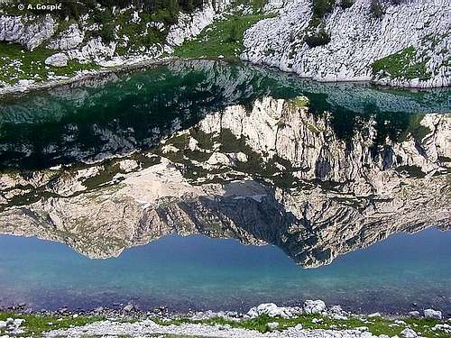
 More information about 7 TRIGLAV LAKES VALLEY is here More information about 7 TRIGLAV LAKES VALLEY is here |
TNP – Triglav National park
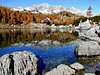
 In the 7 Triglav Lakes valley
TNP is Slovenian largest national park, which is covering almost entire Julian Alps that belong to Slovenia. First ideas to protect this beautiful area came from Dr. Belar. He proposed, in 1908, 7 Triglav Lakes Valley to be protected. Because of land ownership problems it could not be realized. Finally, in 1924, on the area of 14 hectares, Alpine Nature Park was established in the valley, with time limit of 20 years. After WW 2 came the idea of true National Park. 7 Triglav Lakes Valley, together with Triglav, were declared Triglav National Park in 1961, on the area of 20 square km. But the true objectives of NP could not be obtained so finally in 1981, after years of preparation, true TNP was established. It was significantly enlarged to 838 square km with inner (542km square) and outer circle of protection. Park was named after Triglav, nation’s highest peak and symbol, which is almost in the middle of the park. As Julian Alps are mostly made of limestone, park area is exceptionally rich in various karst phenomena, including a special type of the mountain karst. It includes numerous valleys and peaks. All of Slovenian glacial lakes, except Bled Lake, are inside the park. Park is very rich with flora, which is mostly alpine but due to vicinity of Mediterranean climate there are some endemic species. Lowest point of the Park is only 180m.
Triglav National Park
 |
 |
 |
 |
 |
 |
 |
Maps
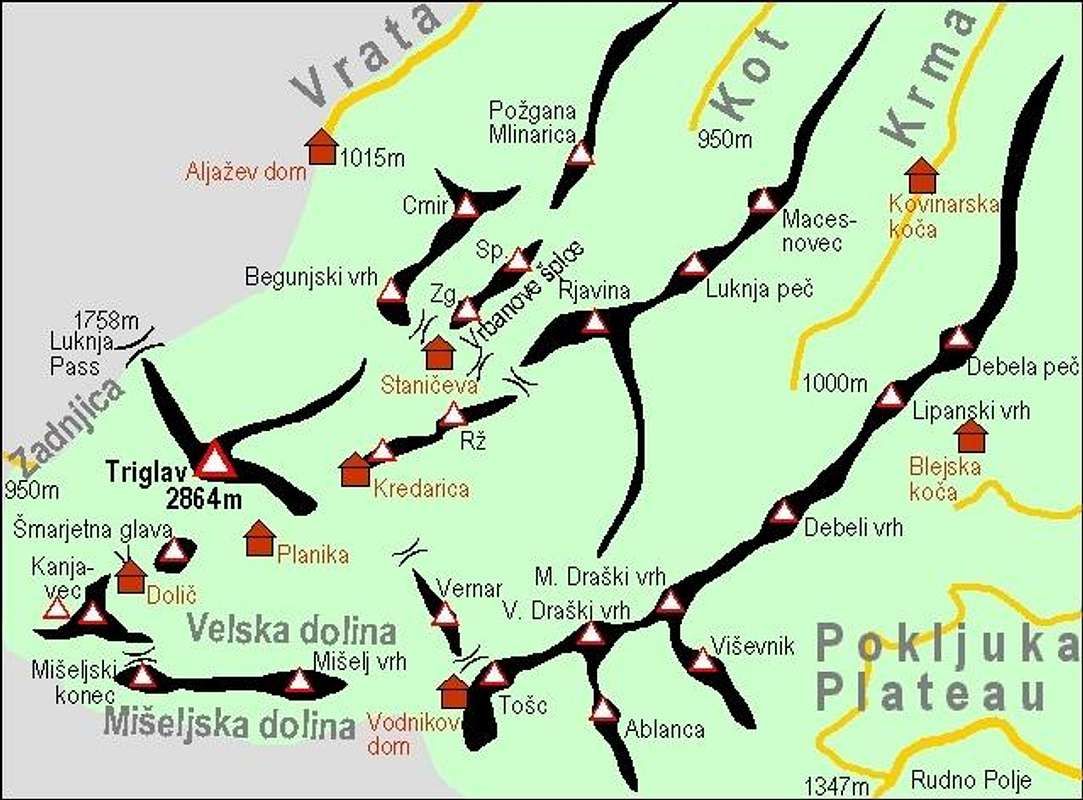 Map of Triglav group by Vid Pogacnik |
 See the original for high resolution! |
 |
 |
 |
 |
Routes Overview
In Slovenia 3 degrees of technical difficulty are used to describe the marked path (trail):
1) Lahka (easy), normal marked path, without fixed steel ropes and pegs
2) Zahtevna (demanding), moderately secured marked path
3) Zelo zahtevna (very demanding), Feratta trail with lot of iron security stuff
Triglav approaches have various degrees of difficulty; technically most demanding are those from Vrata and Zadnjica valleys while other approaches are mostly not secured (easy). Last summit climb is feratta from any of 3 directions. But have in mind that this is purely technical scale of evaluation. For those experienced on secured trails ‘very demanding’ path can be easier and more fun than long southern approaches with just ‘easy’ degree of difficulty but which is physically as same or even more demanding. Bottom line is, shortest Triglav approaches are the steepest ones with most iron while those without iron, from south, are also hard because of the length and altitude difference!
|
VRATA Valley Routes |
| Tominskov Pot: Aljazev Dom hut – Kredarica hut: very demanding / 1500m alt.gain / 5h Kredarica hut – Triglav: very demanding / 400m alt.gain, 40m alt.loss / 1:30h --------------------------------------------------------- Total: 1900m alt.gain / 50m alt.loss / 6:30h |
| Pot Cez Prag: Aljazev Dom hut – Kredarica hut: demanding / 1500m alt.gain / 5h Kredarica hut – Triglav: very demanding / 400m alt.gain, 40m alt.loss / 1:30h --------------------------------------------------------- Total: 1900m alt.gain / 50m alt.loss / 6:30h |
| Bambergov Pot: Aljazev Dom – Luknja Pass – Triglav: very demanding / 1900m alt.gain, 100m alt.loss / 7h ------------------------------------------------------ Total: 1900m alt.gain / 100m alt.loss / 7h |
|
ZADNJICA Valley Routes |
| Via Luknja pass: Zadnjica valley – Luknja pass – Triglav: very demanding / 2200m alt.gain, 100m alt.loss / 7:30h ------------------------------------------------------- Total: 2200m alt.gain / 100m alt.loss / 7:30h |
| Via Dolic hut: Zadnjica valley – Dolic hut: easy / 1450m alt.gain / 4h Dolic hut – Triglav: demanding to very demanding / 700m alt.gain / 2:30h ----------------------------------------- Total: 2150m alt.gain / 6:30h |
|
KOT Valley Route |
| Kot valley – Stanicev Dom hut: easy / 1350m alt.gain / 4:30h Stanicev Dom hut – Kredarica hut: demanding / 230m alt.gain, 50m alt.loss / 1h Kredarica hut – Triglav: very demanding / 400m alt.gain, 40m alt.loss / 1:30h ------------------------------------ Total: 2000m alt.gain / 100m alt.loss / 7h |
|
KRMA Valley Route |
| via Kredarica hut: Krma valley – Konjsko Sedlo pass – Kredarica hut: easy / 1650m alt.gain / 6h Kredarica hut – Triglav: very demanding / 400m alt.gain, 40m alt.loss / 1:30h ----------------------------------------- Total: 2050m alt.gain / 40m alt.loss / 7:30h |
| via Planika hut: Krma valley – Konjsko Sedlo pass – Planika hut: easy / 1500m alt.gain / 5:30h Planika hut – Triglav: very demanding / 470m alt.gain / 1:30h ------------------------------------ Total: 1970m alt.gain / 7h |
|
BOHINJ Lake Routes |
| Bohinj lake (Stara Fuzina village) – Voje valley – Vodnikov hut: easy / 1300m alt.gain / 4h or Bohinj lake (Stara Fuzina village) – Uskovnica pasture – Vodnikov hut: easy / 1300m alt.gain / 5h |
| from Vodnikov via Planika: Vodnikov hut – Konjsko Sedlo pass – Planika hut: easy / 600m alt.gain / 2h Planika hut – Triglav: very demanding / 470m alt.gain / 1:30h ----------------------------------------------------------------------------------- Total: 2370m alt.gain / 7:30h via Voje valley / 8:30h via Uskovnica pasture |
| from Vodnikov via Kredarica: Vodnikov hut – Konjsko Sedlo pass – Kredarica hut: easy / 720m alt.gain / 2:30h Kredarica hut – Triglav: very demanding / 400m alt.gain, 40m alt.loss / 1:30h --------------------------------------------------------------------------------------- Total: 2400m alt.gain / 8h via Voje valley / 9h via Uskovnica pasture |
|
|
|
POKLJUKA Route |
| Rudno Polje – Studorski Preval pass – Vodnikov hut: easy / 560m alt.gain, 80m alt.loss / 3h |
| from Vodnikov via Planika: Vodnikov hut – Konjsko Sedlo pass – Planika hut: easy / 600m alt.gain / 2h Planika hut – Triglav: very demanding / 470m alt.gain / 1:30h ----------------------------------------- Total: 1630m alt.gain / 6:30h |
| from Vodnikov via Kredarica: Vodnikov hut – Konjsko Sedlo pass – Kredarica hut: easy / 720m alt.gain / 2:30h Kredarica hut – Triglav: very demanding / 400m alt.gain, 40m alt.loss / 1:30h ------------------------------------- Total: 1660m alt.gain / 7h |
|
7 TRIGLAV LAKES Valley Route |
| Savica hut – Crno Jezero lake – 7 Triglav Lakes hut: easy to demanding / 1000m alt.gain / 3:30h 7 Triglav Lakes hut – Hribarice pass – Dolic hut: easy / 700m alt.gain, 200m alt.loss / 3:30h |
| direct route from Dolic: Dolic hut – Triglav: demanding to very demanding / 700m alt.gain / 2:30h ----------------------------------------------------------- Total: 2400m alt.gain / 200m alt.loss / 9:30h |
| from Dolic via Planika: Dolic hut – Planika hut: easy / 300m alt.gain, 50m alt.loss / 2h Planika hut – Triglav: very demanding / 470m alt.gain / 1:30h ------------------------------------------------------------ Total: 2470m alt.gain / 250m alt.loss / 10:30h |
Triglav summit climb
------------------------
 |
 |
 |
 |
 |
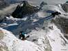
Scenes from the routes
----------------------------
 |
 |
 |
 |
Hike Advices
There are numerous ways to climb Triglav. If you wonder which are the best combinations, this chapter can help you.
~7 Triglav Lakes route~
1) If you can’t start early from Bohinj Lake (Savica hut), reach 7 Triglav Lakes or Prehodavci huts during the day and sleep over. Next day continue towards Triglav. After reaching the summit, sleep over either at Kredarica or Planika huts. On the third day descent via Bohinj or Vrata valley routes. Get back to car at Savica hut by buses.
2) If you start at dawn, you can go all the way to Kredarica or Planika huts or even to Triglav (either directly from Dolic or leave backpack first at Kredarica or Planika). This is tough undertaking, 11h long, whole day route. After reaching the summit, sleep over either at Kredarica or Planika huts. On the second day climb Triglav first (if you haven’t on previous day) and descent via Bohinj or Vrata valley routes. Get back to car at Savica hut by buses.
~Vrata Valley routes~
1) Sleep over at Aljazev Dom hut and start at dawn towards Kredarica hut via Tomiskov or Cez Prag trails. Leave unnecessary things at Kredarica hut and head for summit in the afternoon and return to sleep over. Also you can climb Triglav with backpack and descent to Planika for the night. On the second day climb Triglav (if you didn't during previous day) and continue towards 7 Triglav lakes valley. Sleep over in 7 Triglav Lakes hut. On the third day descent to Bohinj. This is probably the most beautiful way to climb Triglav and get to know most beautiful parts of its kingdom. Of course, on the second day you can return to Vrata valley or descent via Bohinj route.
2) If you can’t start early from Aljazev dom hut, climb to Kredarica during the day and sleep over. On the second day head for the summit without backpack, if you are returning to Vrata valley. If you wish to continue towards 7 Triglav Lakes climb with backpack. Descent directly from the summit towards 7 Triglav lakes valley, via either Planika hut or Dolic hut. Sleep over in 7 Triglav Lakes or Prehodavci huts. On the third day descent to Bohinj.
3) Start at dawn from Aljazev Dom hut and climb Triglav via Bambergov Pot trail. From the summit descent to Kredarica or Planika huts and sleep over. On the second day descent to back to Vrata via Cez Prag or Tominskov Pot trail. This way you close beautiful circle around Triglav and its Face. Of course, you can also continue towards 7 Triglav Lakes or Bohinj, like in previous two combinations.
~Bohinj routes~
If you are stationed at Bohinj and would not like to descent to Vrata valley because it is far from your car here is beautiful circle, which begins and ends on Bohinj.
1) Start at dawn via Bohinj routes and reach Kredarica or Planika hut. Sleep over. On the second day climb the summit and continue towards 7 Triglav Lakes hut. You can sleep over there or if you are fast descent all the way to Bohinj. Use bus from Savica hut to get back to your car at Stara Fuzina or Ukanc.
2) Start at dawn via 7 Triglav Lakes route and continue all the way to Kredarica or Planika huts. On the second day leave backpacks in the hut, climb Triglav and return. Continue towards Bohinj via Bohinj routes. Take a bus to Savica hut if car is waiting there.
These are just a few of numerous possibilities.
 |
 |
 |
 |
 |
Ski Tours Around Triglav
by Vid Pogacnik
Triglav is also a mountain for tour skiers. But skiing can not be done from the top of it. Or, it can, if you are the best among the best.
Several ski routes start from Kredarica and still offer some 1500 meters of descent. The most popular ski tour is to Krma Valley, in late spring many skiers descend in the Valley behind Cmir, you can ski also down in Kot Valley. In recent years also a hard alpinistic ski tour over the Triglav north face - Slovenian Route - is popular.
On the other, western side of Triglav, Dolic area is very appropriate for skiing. Many skiers sleep there, take some of the nearest shoulders and descend on Velo polje valley and further down in Bohinj. Even more towards west Kanjavec (2558m) stands. It is the highest skiing summit in Julian Alps, and can be reached from Dolic. But this is already another story, worth of another SummitPost page...
 |
 |
|
 |
 |
 |
When To Climb
As any peak, Triglav can be climbed, year round, depending on your skills and wishes.
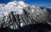
Winter is longest period on Triglav. Because of the vicinity of the sea there is lot of snow. Highest depth on record is 7 meters! Snow usually covers highest area in October. It accumulates till May when it slowly begins to melt. Depending of the year, snow covers highest area till end of June. It is also very cold. Temperatures around -20C are not rare. You need full winter equipment. Easiest way to approach Triglav in winter is through Krma valley. Climb is long so you have to be in good shape. It is not technical till you reach Kredarica hut. Summit climb is only reserved for experienced mountaineers and climbers. Pegs and steel ropes are under snow so you are free climbing, on some places, almost perpendicular cliffs! Vrata valley routes are only for experts in snowy period. Other routes are tough and long in winter and cannot be done in a day (one direction). Perhaps the best time to climb in winter is the end of March and April when it is still cold (good snow conditions) and there is most snow.
Spring is almost non existent in the heights of Triglav. It’s like winter with longer days, which is good for longer routes. Snow quality will deteriorate after mid May. June is not a good month to climb. There is still lot of snow but quality is poor. And when snow is gone weather suddenly jumps into summer mode. But you can find classic spring in the lower sections of Triglav routes where there is greenery. There are most flowers in June and July.
Summer months on Triglav are July and August. Thousands upon thousands, from all directions, pilgrimage towards Triglav in this period. If you don’t like crowds better avoid summer, if it can be called that way, because temperatures around Triglav don’t exceed 10°C too often. That happens on hot days when temps in the Slovenian plains and on the coast reach 30°C. No equipment is needed in summer, except helmet and ropes for climbing (ferrata) trails (not necessary, depends on personal taste). Even in this period you will see and walk over quite a lot of remaining snow, depending of the year. Always have warm clothes with you, snow is possible on Triglav even in mid summer.
Autumn is perhaps best time to visit if you don’t like crowds. In September and October days are still quite long and Sun is not beating hard, views are great. At the beginning of October forested areas are beautifully colored, especially 7 Triglav Lakes valley, where there are lot of larch trees which put on its golden display.
 |
 |
 |
 |
Weather Information
Mountain conditions on Triglav are well known thanks to Kredarica (2515m) hut and meteo station, which is just below the Triglav.
Best overview of daily data values is provided by Russian Weather Server -> Kredarica @ Infospace.ru
You can also observe current conditions and forecast for Kredarica on the Wunderground meteo site.
Wunderground - Kredarica page
Current weather and forecasts can also be found on the Slovenian Environment Agency pages.
Direct link to Current Conditions page
Direct link to Snow Depth page
 |
 |
 |
 |
 |
Current Conditions & Weather Stats for Kredarica, Triglav
If data displayed here is not from today you can check conditions on the links above.
Observing Station: Kredarica hut (2515m), Triglav
Note: Because Kredarica hut is 350m below Triglav expect summit temperature to be 2-3°C lower
DATE: October 3rd 2007
TEMPERATURE at 7/13h: 7/10°C
WEATHER: mostly clear
WIND: NE, 1m/s average speed (light)
SITUATION: High pressure is gradually weakening as frontal system is approaching from W-NW. It will bring precipitation during Friday and Saturday.
SNOW: 30cm at 7h (-5cm in last 24h, last snowfall: September 30th). Snow remains are present all year in higher areas of Julian Alps.
~ seasonal max of 55cm recorded on September 29th 2007
~ compact snow on the ground since: September 27th 2007
~ first snowfall of 07/08 season was recorded on September 4th 2007
--------------------------------------------------------------------------------------------------------------------------------
Current photo from Kredarica
--------------------------------------------------------------------------------------------------------------------------------
SNOW STATS
Maximum snow depth for 2005/2006 season of 495cm was recorded on May 1st 2006
Maximum snow depth for 2004/2005 season of 240cm was recorded on April 26th 2005
Maximum snow depth for 2003/2004 season of 465cm was recorded on April 7th 2004
Maximum snow depth for 2002/2003 season of 240cm was recorded on April 4th 2003
Maximum snow depth for 2001/2002 season of 195cm was recorded on April 25th 2002
Maximum snow depth for 2000/2001 season of 700cm was recorded on April 22nd 2001
Maximum snow depth for 1999/2000 season of 310cm was recorded on April 13th 2000
Those 7 meters or 23 feet of snow recorded in 2001 is all time high for Kredarica and Triglav, at least since meteo station exists
SNOW STATS for 04/05 season (from the beginning of August till the end of July)
~ First snowfall: Aug 27th 2004 (7cm)
~ Seasonal max: 240cm on April 26th
~ Last snowfall: June 9th 2005
~ Last day with snow on the ground: June 16th 2005 (5cm)
~ Number of days with compact snow on the ground: 236
SNOW STATS for 05/06 season (from the beginning of August till the end of July)
~ first snowfall: August 7th 2005
~ seasonal max: 495cm between April 30th-May 1st 2006
~ last snowfall: June 7th 2006
~ Last day with snow on the ground: June 28th 2006
~ Number of days with compact snow on the ground: 247
SNOW STATS for 06/07 season (from the beginning of August till the end of July)
~ first snowfall of 06/07 season was recorded on August 4th 2006
~ seasonal max of 300cm between March 31st to April 2nd 2007 and on April 4th
Getting There
There many routes which lead towards Triglav. How to reach their starting points is described together with each route.
Main centres near Triglav starting points are Mojstrana and Bohinj.
By Plane
If you want to reach Ljubljana, Slovenian capital, by plane check a timetable on the site of Adria Airways, a national airline.
By Bus
From Ljubljana buses depart towards Kranjska Gora and Bohinj every 60 minutes.
By Train
Bohinj is connected with Ljubljana by train. In Mojstrana direction, train will take you to Jesenice town, 10km before Mojstrana where you would have to wait for the bus from Ljubljana. Jesenice are on the main railway from Ljubljana towards Austria and Germany so it can be reached by train from Western Europe.
Slovenian railways
German railways
By Car
From central Europe via Villach, Austria: Via Karavanke tunnel or Korensko Sedlo pass.
From Western Europe via Udine, Italy: exit Udine – Villach highway in Tarvisio. Tarvisio – Kranjska Gora 20km.
 |
Objects along Triglav routes
Note: all the huts are preparing several meals each day and have drinks.
Koca pri Savici (653m) (Hut near Savica) stands in the beech forest, at the bottom of glacial cirque Komarca and its cliffs. This is the beginning of Bohinj lake valley. It is accessible by car from Bled, via Bohinj (36km). Parking is not free. Opening year was 1951 after the renovation of previous Yugoslav border watch-house. Vicinity of Savica waterfall made it very popular tourist hut so in 1990 it was enlarged. Hut is open from beginning of June till end of September. It has electricity, hot water and 32 beds.
--------------------------------------------------------------------------------------------
 Koca pri Sedmerih Triglavskih Jezerih (1685m) (Hut on Seven Triglav lakes) stands on the shore of Dvojno Jezero (Double or Twin Lake) in the valley of 7 Triglav Lakes. North of the hut is Mocivec artificial lake. It was built by Austrian Tourist Club in 1880. Ljubljana-Matica mountaineering club took it over in 1919. In 1955 it was significantly enlarged and again in 1988. By the hut is small winter room house. Hut is open from the end of June till the beginning of October. It has 200 beds in rooms of various sizes but is often very crowded. Winter room has 18 beds. Has cold water and electricity from generator. It is beautifully placed, just by the lake and has beautiful views on the cliffs and peaks around. Koca pri Sedmerih Triglavskih Jezerih (1685m) (Hut on Seven Triglav lakes) stands on the shore of Dvojno Jezero (Double or Twin Lake) in the valley of 7 Triglav Lakes. North of the hut is Mocivec artificial lake. It was built by Austrian Tourist Club in 1880. Ljubljana-Matica mountaineering club took it over in 1919. In 1955 it was significantly enlarged and again in 1988. By the hut is small winter room house. Hut is open from the end of June till the beginning of October. It has 200 beds in rooms of various sizes but is often very crowded. Winter room has 18 beds. Has cold water and electricity from generator. It is beautifully placed, just by the lake and has beautiful views on the cliffs and peaks around. |
--------------------------------------------------------------------------------------------
 Zasavska Koca na Prehodavcih (2071m) (Zasavska Hut on Prehodavci) stands on Prehodavci pass, between Spicje and Kanjavec mountains. On the east is 7 Triglav Lakes Valley while on the west is Trenta valley, deep bellow. It was opened in 1954. In 1973 enlarged hut was reopened. In 1987 it was readapted. It has 55 beds, cold water, and power generator. View from the hut is fantastic. Hut is open from beginning of July till the end of September. Zasavska Koca na Prehodavcih (2071m) (Zasavska Hut on Prehodavci) stands on Prehodavci pass, between Spicje and Kanjavec mountains. On the east is 7 Triglav Lakes Valley while on the west is Trenta valley, deep bellow. It was opened in 1954. In 1973 enlarged hut was reopened. In 1987 it was readapted. It has 55 beds, cold water, and power generator. View from the hut is fantastic. Hut is open from beginning of July till the end of September. |
--------------------------------------------------------------------------------------------
 Trzaska koca na Dolicu (2151m) (Trieste Hut on Dolic) stands on the Dolic pass, between Kanjavec (2568m) and Triglav (2864m). First object was built by Italians in 1930. Renewed hut was reopened in 1948 but destroyed by avalanche in 1951. In 1952 they began to build new hut on a safer place, few hundred meters away. New hut was opened in 1953 and was named Trzaska Koca (Trieste hut) because Slovenians living in Trieste, Italy, always wanted to have hut close to Triglav. In 1973 in was enlarged. It is open from the end June till beginning of October. It has 144 beds, cold water and power generator. View from the hut is beautiful on the peaks behind the Trenta valley. Trzaska koca na Dolicu (2151m) (Trieste Hut on Dolic) stands on the Dolic pass, between Kanjavec (2568m) and Triglav (2864m). First object was built by Italians in 1930. Renewed hut was reopened in 1948 but destroyed by avalanche in 1951. In 1952 they began to build new hut on a safer place, few hundred meters away. New hut was opened in 1953 and was named Trzaska Koca (Trieste hut) because Slovenians living in Trieste, Italy, always wanted to have hut close to Triglav. In 1973 in was enlarged. It is open from the end June till beginning of October. It has 144 beds, cold water and power generator. View from the hut is beautiful on the peaks behind the Trenta valley. |
--------------------------------------------------------------------------------------------
 Dom Planika pod Triglavom (2401m) (Planika Hut Below Triglav) stands on the high plateau Ledine, below southern cliffs of Triglav (2864m). It has long history. First hut was opened in 1871. It changed names and was resized and renewed few times, last time in 1987, when second object was erected new to old hut. It is open from end of June till end of September. It has 74 beds in main object and dozens more in new one, cold water and power generator. View from the hut is very wide towards east and south. Dom Planika pod Triglavom (2401m) (Planika Hut Below Triglav) stands on the high plateau Ledine, below southern cliffs of Triglav (2864m). It has long history. First hut was opened in 1871. It changed names and was resized and renewed few times, last time in 1987, when second object was erected new to old hut. It is open from end of June till end of September. It has 74 beds in main object and dozens more in new one, cold water and power generator. View from the hut is very wide towards east and south. |
--------------------------------------------------------------------------------------------
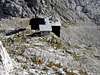
| Triglavski Dom na Kredarici (2515m) (Triglav Hut on Kredarica) is largest and highest lying hut in Slovenia. It is placed just above the pass between Kredarica (2540m) and Triglav (2864m). It was built by Slovenian mountaineering society in 1896 behind the idea of Jakob Aljaz. Since then it was resized many times. Today’s look is from 1984. In 1992 chapel was erected next to the hut. Every hour its bell rings. Later another object was erected next to the hut. It is open during whole year because it is also a meteorological station. In winter season it is partially supplied but meteorologists always prepare some hot meal and tea. It has 300 beds, 5 dining rooms and is still overcrowded in summer. It also has cold water, power generator and GSM public phone. Due to open spaces around and high lying position, view from the hut is extraordinary. Huge Triglav only obscures it towards west. |
--------------------------------------------------------------------------------------------
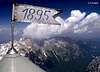
 Aljazev Stolp on Triglav (2864m). Jakob Aljaz, famous priest from Dovje-Mojstrana village, and explorer of Julian Alps, came in 1895 to idea to erect Aljazev Stolp and show Germans that Triglav is Slovenian mountain. He decided to privately fund placing of small round prop on the summit of Triglav to act like a symbol, viewpoint and small shelter in case of sudden storm. He bought ground on the summit of Triglav from Dovje County for 1 goldinar. He designed pillar that will be 1,90m high and will have 1,25m in diameter and could accommodate 4 to 5 people. It would be highest lying Slovenian object. Idea was very enthusiastic for the time being. In the August of 1895, 6 strong men carried whole week 20kg heavy steel plates and other material from Vrata valley to Triglav summit. On August 7th, Anton Belec and 4 assistants put it together in 5 hours and erected 1m high wall around it to make it more resistant to fierce winds. Since then it is standing proudly on the summit of Triglav, now over hundred years. It became a National symbol and in 1990 it was declared a cultural and historical monument. Aljazev Stolp on Triglav (2864m). Jakob Aljaz, famous priest from Dovje-Mojstrana village, and explorer of Julian Alps, came in 1895 to idea to erect Aljazev Stolp and show Germans that Triglav is Slovenian mountain. He decided to privately fund placing of small round prop on the summit of Triglav to act like a symbol, viewpoint and small shelter in case of sudden storm. He bought ground on the summit of Triglav from Dovje County for 1 goldinar. He designed pillar that will be 1,90m high and will have 1,25m in diameter and could accommodate 4 to 5 people. It would be highest lying Slovenian object. Idea was very enthusiastic for the time being. In the August of 1895, 6 strong men carried whole week 20kg heavy steel plates and other material from Vrata valley to Triglav summit. On August 7th, Anton Belec and 4 assistants put it together in 5 hours and erected 1m high wall around it to make it more resistant to fierce winds. Since then it is standing proudly on the summit of Triglav, now over hundred years. It became a National symbol and in 1990 it was declared a cultural and historical monument. |
--------------------------------------------------------------------------------------------
 Dom Valentina Stanica pod Triglavom (2332m) (Valentin Stanic Hut Below Triglav) stands on the small head at the edge of Kotel basin and above steeply falling Kot valley. Beside Planika and Kredarica it is third ‘Triglav’ hut. First hut on this location was built in 1887 by German-Austrian Mountain Society. In 1961 new and enlarged hut was reopened. Hut has 136 beds, cold water, power generator etc. Hut also has beautiful view towards Triglav, which from here shows its very powerful side. Hut is open from beginning of July till the end of September. Dom Valentina Stanica pod Triglavom (2332m) (Valentin Stanic Hut Below Triglav) stands on the small head at the edge of Kotel basin and above steeply falling Kot valley. Beside Planika and Kredarica it is third ‘Triglav’ hut. First hut on this location was built in 1887 by German-Austrian Mountain Society. In 1961 new and enlarged hut was reopened. Hut has 136 beds, cold water, power generator etc. Hut also has beautiful view towards Triglav, which from here shows its very powerful side. Hut is open from beginning of July till the end of September. |
--------------------------------------------------------------------------------------------
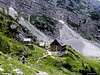
 Aljazev Dom (1015m) (Aljaz Hut) is placed in upper part of Vrata valley, near the forest end. It is accessible by car, 12km from Mojstrana village, which lies on the main road from Ljubljana (72km) to Kranjska Gora resort (12km). It was opened in 1896. In 1909 the hut was destroyed by avalanche. New hut was opened the next year where it stands today. It has 150 beds and is open from beginning of May till the end of October. Winter room has 8 beds. Hut also has phone, electricity, warm water and so on. From the hut view is beautiful on the peaks around the valley, which rise wildly above it, and especially on Triglav and its North face. Aljazev Dom (1015m) (Aljaz Hut) is placed in upper part of Vrata valley, near the forest end. It is accessible by car, 12km from Mojstrana village, which lies on the main road from Ljubljana (72km) to Kranjska Gora resort (12km). It was opened in 1896. In 1909 the hut was destroyed by avalanche. New hut was opened the next year where it stands today. It has 150 beds and is open from beginning of May till the end of October. Winter room has 8 beds. Hut also has phone, electricity, warm water and so on. From the hut view is beautiful on the peaks around the valley, which rise wildly above it, and especially on Triglav and its North face. |
--------------------------------------------------------------------------------------------
Kovinarska Koca v Krmi (870m) (Kovinarska Hut in Krma) stands on the edge of Zasipska Planina meadows in Krma valley. Hut was opened in 1948 in renewed shepherd’s house. In 1959 new hut was opened. In 1983 freshly renewed hut was reopened. It has 27 beds, water, electricity etc. From the hut is nice view on the peaks surrounding Krma valley, which are rising wildly above it. Hut is open from beginning of June till the end of September.
--------------------------------------------------------------------------------------------
 Vodnikov Dom na Velem Polju (1817m) (Vodnik hut on Velo Polje) stands on the slopes on Tosc (2275m), above Velo Polje field. First hut was erected here in 1895. It was 100th anniversary of Valentin Vodnik’s, who is famous Slovenian poet, Triglav ascent and they named it after him. In 1909 hut was moved little bit on today’s position. Because of poor condition, hut was demolished and new hut has been built for 4 years and opened in 1958. Later was renewed, last time in 1986. It has 53 beds and 10 in winter room, hot water and power generator. View from the hut is very beautiful towards Velo Polje field bellow, peaks around and especially towards Triglav. Hut is open from beginning of June till mid October. Vodnikov Dom na Velem Polju (1817m) (Vodnik hut on Velo Polje) stands on the slopes on Tosc (2275m), above Velo Polje field. First hut was erected here in 1895. It was 100th anniversary of Valentin Vodnik’s, who is famous Slovenian poet, Triglav ascent and they named it after him. In 1909 hut was moved little bit on today’s position. Because of poor condition, hut was demolished and new hut has been built for 4 years and opened in 1958. Later was renewed, last time in 1986. It has 53 beds and 10 in winter room, hot water and power generator. View from the hut is very beautiful towards Velo Polje field bellow, peaks around and especially towards Triglav. Hut is open from beginning of June till mid October. |
--------------------------------------------------------------------------------------------
Planinska Koca na Uskovnici (1154m) (Mountain Hut on Uskovnica) stands in the lower part of Uskovnica, large meadows area above the Voje valley, on the way from Bohinj towards Triglav. Hut was erected and opened in 1955. In 1965 it was enlarged. In 1981 it was renamed to ‘Hut of Jesenisko-Bohinjskega Odreda on Uskovnica’, in memory of brigade who fought in WW II on this area. Hut has 46 beds, hot water, electricity etc. View from the hut is nice towards lower Bohinj range of Julian Alps. Hut is open from beginning of June till mid October.
--------------------------------------------------------------------------------------------
Planinska Koca Bohinjskih Prvoborcev na Vojah (690m) (Mountain Hut of Bohinjskih Prvoborcev in Voje) or simply Koca v Vojah stands in the glacial Voje valley, by the Mostnica river. Huge field and meadows begin here, which are some 3km long. Hut was opened in 1982 and was named after partisan fighters from WW II from Bohinj region. It has 40 beds, cold water and power generator. It is open from beginning of June till the end of September and during holidays. View from the hut is limited by steep forested slopes on the east and west. On the north is mighty Tosc (2275m).
---------------------------------------------------------------------------------------------
Other objects shots
 |
 |
 |
|
 |
Camping
Camping inside the National Park is forbidden. Beside the mountain huts there are plenty of hotels and private apartments in the towns and villages, which surround the area. Here are few links where you can find info on accommodations closer and further away:
Kranjska Gora
Mojstrana
Bled
Bohinj
Bovec
Red Tape
Triglav and all routes starting points are inside Triglav National Park. Entrance is free but parking is charged on most locations. It isn't expensive.
 |
 |
 |
Your Summit Shots
Some of people's summit shots.
 |
 |
 |
 |
 |
External Links
- Triglav National Park
Official page of Triglav National Park - Hiking in Slovenia
Some general information - Slovenia
Country info - Weather in Slovenia
Before you take off, check out the weather on Triglav in real time.
The mountain hut at Kredarica (2515m) serves as a weather station. - Ascent of Triglav July 1992
Velebit - Jul 14, 2004 6:06 am - Voted 10/10
Untitled CommentYes Vid :-) there is no way to do it automaticaly, especially description of current situation (high, lows and fronts)
Vid Pogachnik - Jul 14, 2004 8:07 am - Voted 10/10
Untitled CommentSvaka ti èast!!! I za Velebit isto!
Vid Pogachnik - Jul 13, 2004 11:33 am - Voted 10/10
Untitled Comment... really manually updating weather conditions each day?
Velebit - Jul 14, 2004 6:06 am - Voted 10/10
Untitled CommentYes Vid :-) there is no way to do it automaticaly, especially description of current situation (high, lows and fronts)
borut - Mar 16, 2014 2:59 pm - Hasn't voted
Corrections for the Section: Stena (The Face)A few corrections in the route list: > Slovenska Smer route: II (alternates III), 700-800 m. > Nemška Smer (German route): IV-/III, 1000-1300 m. > Zimmer - Jahn exit (variation of German route): IV-/II-III, 300 m (alltogether 800 m). > Bavarska Smer (Bavarian route): IV+, 500 m. > Skalaška in Gorenjska Smer route: V+/IV+, 1000 m. > Čopov Steber (Chop pillar) route: VI+, 450 m (alltogether 1000 m). > Prusik-Szalay route: V/IV+, 1000 m. > Kunaver-Drašler v Sfingi: VII+/VI-VII, 280 m. > Stopnice v Nebo (Stairs to the Sky): VII-/V-VI, 500m. > Zlatorogove Police (Zlatorog ledges): IV-/I-III. (edit)
Poncherelo - Feb 7, 2017 2:50 pm - Hasn't voted
Mountain Guide for Mount TriglavThis article has been super useful for me while preparing my ascent of Mt Triglav ! Thanks ! I have been guided by a local IFMGA mountain guide when I was there. Really Amazing guy ! You'll find his details here : https://www.explore-share.com/trip/climbing-mount-triglav-2864m/ I strongly recommend him ! Next trip for me there will be a ski touring traverse.