
|
|
Route |
|---|---|
|
|
39.58280°N / 105.6681°W |
|
|
Hike, some scramble |
|
|
Most of a day |
|
|
Class 2 - a hike |
|
|
Approach
Take US 285 from Denver about 44 miles to the small town of Grant. Turn right on Guanella Pass Road and follow it for 5 miles to the Scott Gomer trailhead - which is on the right side of the road and clearly visible. The trailhead is at 9,600'
Route Description
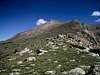
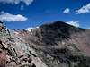
The trail (the Abyss Lake Trail, #602) is very easy to follow, and climbs very gradually through shady woods for about 3.5 miles. It eventually intersects trail #603, and there is a sign. At this point leave the trail and hike northeast towards the ridge. Find a path through the brush, climb through the woods and hike to the top of the ridge - about a mile. You are now at 11,900'. Angle left and follow the ridge up to the false summit, which is at about 13,700'. Once you reach the top, the remainder of the route is obvious, easy, and quick - you'll drop down a bit and intersect the standard route to Bierstadt, and run into the crowd that is generally there on summer weekends (up until that point you probably won't have seen a soul). Total distance is a little over 6 miles, and total gain is about 4,400'. This is a great hike - little traveled, great scenery, technically easy, yet still challenging.
 |  |  |  |
Essential Gear
This is a non-technical hike - no special equipment necessary. Like all Colorado 14'ers, be prepared for rapidly changing weather, including sleet even in August. There are streams until you leave treeline, so if you bring a pump you can make do with limited water.
Miscellaneous Info
If you have information about this route that doesn't pertain to any of the other sections, please add it here.