
|
|
Route |
|---|---|
|
|
40.27920°N / 105.6531°W |
|
|
Hike |
|
|
Most of a day |
|
|
class 2 |
|
|
Approach
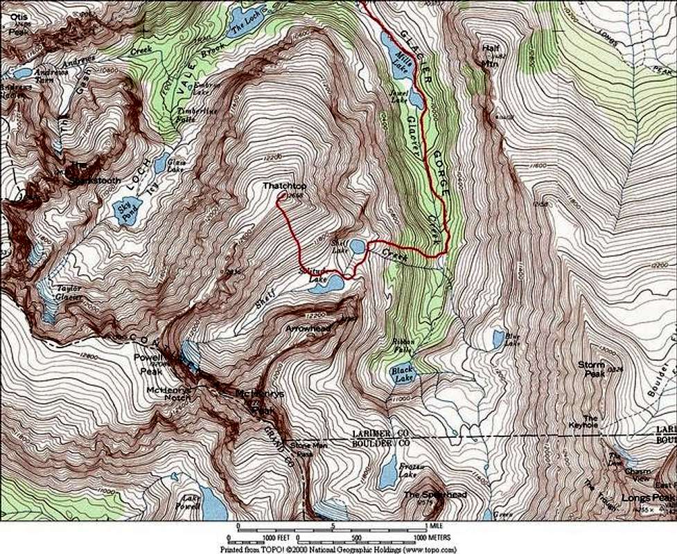
Round Trip-10 miles
Vertical Gain 3,400-ft
Starting at the Glacier Gorge TH (9,240-ft) hike about .5 miles to the Glacier Gorge Junction, it is signed. You want the “Mills Lake” option, which is to the right. Hike 1.1 miles to another signed trail junction. This is the “North Longs Peak Trail” junction. You want the “Lock Vale” or the “Glacier Gorge” option, which is to the right. A few hundred yards past this junction you will get your first view of Thatchtop, it is rounded mass directly southwest in front of you. At 1.7 mile from the TH you will come to yet another junction, this is the “Lock Vale/Glacier Gorge” junction, and you obviously want Glacier Gorge. Continue about a half-mile to the beautiful Mills Lake. From here you get your first full view of the gorge area. It is 2.4 miles to the southern end of Mills Lake and the beginning of Jewel Lake.
After passing Jewel Lake continue another .82 mile until you come to an area of downfall from a prior avalanche. At this point look down to you’re right and locate the faint Solitude Lake Trail as it descends down to Glacier Creek. Locating this trail may be the crux of your day, it is not signed and not very easy to locate. You must find this trail, the slope up to Shelf Lake is choked with a load of downfall, plus it’s steep as hell.
Route Description
Cross Glacier Creek on a few huge boulders and again locate the trail. Once on the trail on the west side of the creek it becomes easier to follow. From here begin a 1000-ft steep hike up to Shelf Lake. Negotiate some willows and krumholtz around Shelf Lake and find the beautiful shelved waterfall above the lake. Ascend this waterfall to the south and continue to Solitude Lake.
From the lake, Thatchtop’s boulder laden south slopes are clearly visible. Hike around the north end of Solitude Lake and begin a 1,232-ft, class 2 hike up the south slopes to the summit.
Essential Gear
Topo map.
Miscellaneous Info
If you have information about this route that doesn't pertain to any of the other sections, please add it here.
argothor - Sep 6, 2022 8:04 pm - Hasn't voted
Lock vs LochIt is Loch Vale, not Lock Vale. Loch is Scottish for Lake. Lock is something else entirely.