
|
|
Route |
|---|---|
|
|
40.38460°N / 111.636°W |
|
|
Hike |
|
|
Most of a day |
|
|
Walk up |
|
|
Approach
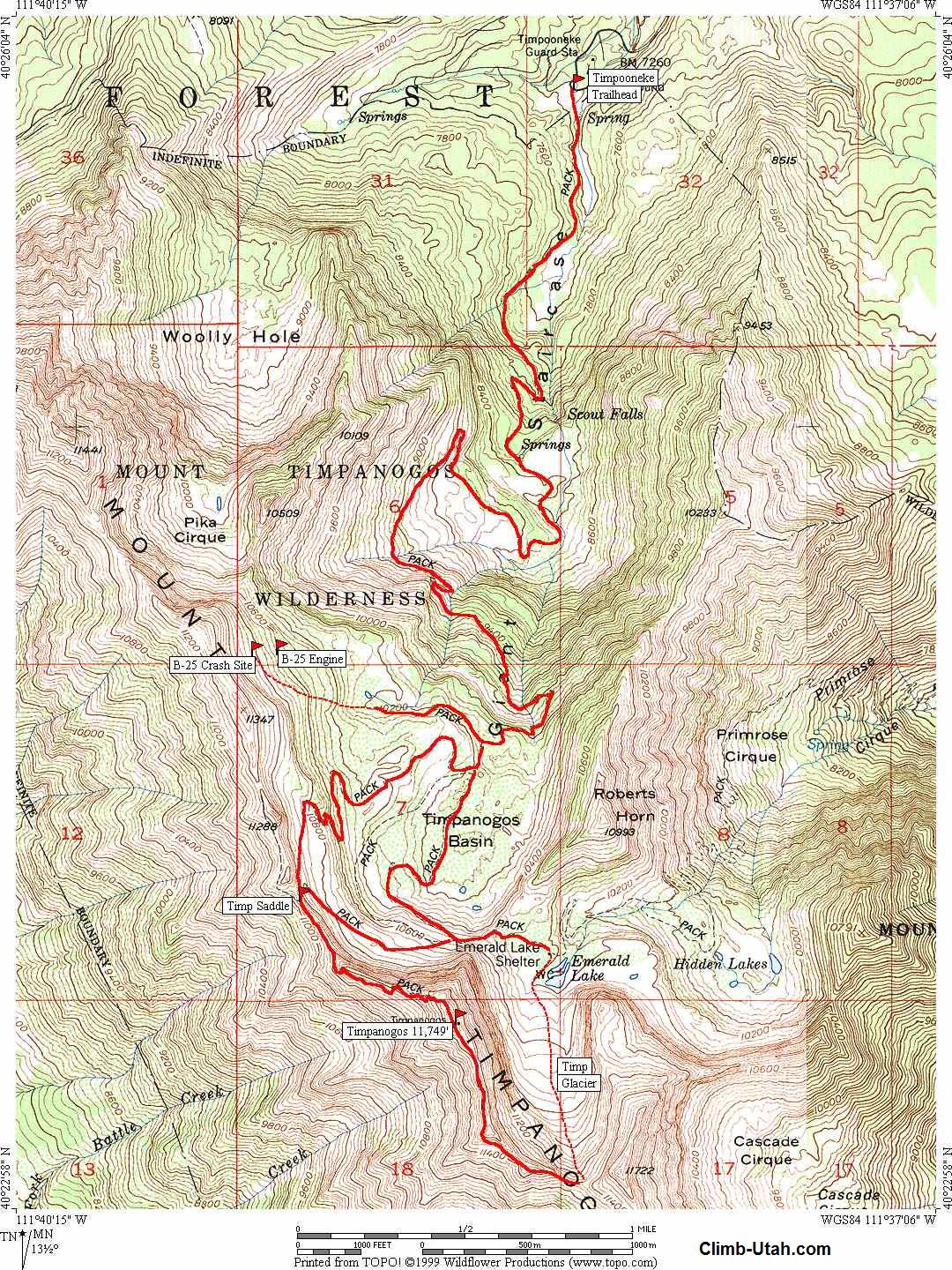
From I-15 take the 284 exit(no longer the 287 exit as shown on some maps so be aware of this change) and go east on highway 92. Also note that it mentions Alpine and Cedar Hills and if you see this, you've got the correct exit. Go 8 miles until you enter the American Fork Canyon and you'll be confronted by a fee booth. Continue on another 8.2 miles (passing the Timpanogos Cave national monument area) until you come to the Timpooneke Campground on the right side of the road. The trailhead to the Timpooneke route is just beyond the campground area.
 |
 |
 |
 |
 |
Route Description
In 2012, the parking area at the trailhead, located just beyond the campground was re-done and generally has enough parking for most days of the week. Saturday mornings during the summer often finds the parking lot filled by 5 a.m. so be aware of that . A Forest service style vault toilet is found also with an information kiosk just to its right. The trail takes off from the bathroom area and angles to the right. If you drop down, you are on the wrong trail. There is a small SAR booth and a sign in board on the correct trail.
Nice map HERE
This approach provides you with over 14+ miles round trip starting at an elevation of 7,360 feet. Total elevation gain is 4389 feet. This is my favorite of the two trails, which although about a mile longer than the Aspen Grove trail, it is a much more interesting one. As you head up the trail, you will see Scout Falls off to your left. Nearing the short access trail to the falls, you will encounter a switchback and cross two wooden "bridges" that keep your feet dry as you go past a swampy section. The trail then switchbacks toward Scout Falls which has a sign announcing the short trail. The Timpanooke trail goes to the right when you meet the sign and you will have one more switchback to deal with. The trail then leaves the switchbacks and starts up toward the first bench, an area where I've encountered moose on many occasions.
The first feature of note is called the "Giant Staircase" and gives you a good feel for the geologic structure of this area. The trail goes up through the "Staircase" and you start to feel the elevation, especially if you've come from sea level within the last couple of days. You start to get views to the north showing off some of the other rugged peaks such as the North Peak of Timp and Mill Canyon Peak. The trail climbs and contours, climbs and contours until you eventually find yourself with a view of the north face of Mt. Timpanogos when you enter the basin at 10000+ feet. The north face is a sheer 1630 foot drop and is quite impressive. Late July in this basin is often a wild flower wonderland.
The Aspen Grove trail intersects the Timpooneke trail nearby and the two join up just prior to reaching the saddle. From the saddle, you get tremendous views down onto the cities of Provo and Orem and further out to Utah Lake and the mountains beyond. For many, this is a good point to turn around at.
For those who want the summit, another 700 feet of elevation remains and about 1/2 mile of trail. Well worth every extra step.
However, if snow lingers or covers the trail, care must be exercised and an ice axe would be worthwhile. One of my favorite spots on the whole trail is where the trail climbs between two rock walls making short but steep switchbacks. Soon the summit hut comes into view and with each step gets closer and closer. The hut was built as a triangulation station for Utah county around the 1920's. Views from the summit are superb.
SHORTCUTTING: There are a few places on this trail where it switchbacks and there are always those who get impatient and try to take the quickest way. The problem with this practice is that it causes erosion and scars the area between the switchbacks. Please stay on the trail and resist the urge to shortcut.
Essential Gear
Depending on how early or late in the season you decide to go, an ice axe may be necessary if snow is present. Winter mountaineering could require the use of a rope on the upper parts of the mountain and this mountain was used by the Utah mountaineering group as the training ground for Mt. Everest preparation.
Miscellaneous Info
If you have information about this route that doesn't pertain to any of the other sections, please add it here. Here is a post that was added and is worth adding to this section:
Author: phil@phil-lowry.com
Date: Jan 11, 2003 9:09 PM
I have been measuring the mileages on the two major Timp trails (and the one not mentioned on the website, the Hartsky cutoff) for about five years with both mechanical wheels and GPS plots onto digital elevation models.
The Timpooneke Trail is 7.03 miles long one-way, while the Aspen Grove Trail is 6.82 miles long one-way. I have communicated this info to my buddies at the Forest Service but they refuse to update their information or signs. Bureaucracy sucks.
Yes, I'm the geek who's climbed the mountain 259 times (12 more than noted on the site, since another season has passed since that post . . . ;-))
Happy trails
Phil Lowry