
-
 13640 Hits
-
 73.06% Score
-
 3 Votes
|
|
Route |
|---|---|
|
|
40.54350°N / 111.7314°W |
|
|
Hike with scrambling and routefinding |
|
|
Most of a day |
|
|
Class 3 |
|
|
Overview
This is the longer of the two primary routes to the summit of North Thunder Mountain. The route follows the Bells Canyon trail to Upper Bells Reservoir, followed by routefinding to the saddle between Bells Canyon and Thunder Bowl. From the saddle the route crosses Thunder Bowl, then ascends the west face of North Thunder. | 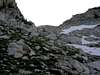 |
Getting There
The Bells Canyon trailhead begins at 10245 South Wasatch Boulevard. There is a parking area for the trailhead on the east side of Wasatch Boulevard.To reach the Bells Canyon trailhead from I-215, take the 6200 South exit and follow Wasatch Boulevard south for approximately 6 miles to 10245 South. The Bells Canyon trailhead can also be accessed via I-15 by taking the 9000 South Exit, then following 9000 South east for 6 miles to Wasatch Boulevard (by which time 9000 South has become 9800 South). Turn right (south) on Wasatch Boulevard and drive for 0.7 miles to the trailhead parking area.
For GPS users, the Bells Canyon trailhead is located at NAD27 12T 432036E 4490598N, el. 5,120 ft.
Stats
One-Way Hiking Distance: 5.25 milesElevation Gain: 6,030 ft.
Average Gain per Mile: 1,150 ft.
Trailhead Elevation: 5,120 ft.
Summit Elevation: 11,150 ft.
Route Description
From the Bells Canyon Trailhead at the north end of the parking area, follow the trail up though a residential area, across a bridge, then up a steep stretch to Lower Bells Canyon Reservoir.Follow the dirt road which circles around the west and then north sides of the reservoir. About 200 yards beyond the reservoir the Bells Canyon trail leaves the road on the left, marked by a sign.
After leaving the dirt road the trail meanders through brush and scrub oak until it reaches a small bridge over the Bells Canyon stream, approximately 0.5 miles from the lower reservoir.
From the bridge the trail continues east on the south side of the stream for approximately 2 miles, then makes a sharp turn to the right (south). Approximately 100 yards after making the turn south, cross to the east side of the stream on a very primitive 'bridge' constructed of logs and 2x4's (during periods of low runoff the stream may be crossed at a number of other spots as well).
Pick up the trail on the east side of the stream and continue hiking south. From this point onward the trail slowly deteriorates and becomes increasingly difficult to follow. If the trail is lost just continue heading south and upward along the path of least resistance, and eventually either the trail or a periodic cairn should be spotted - do your best, and try to keep the cursing to a minimum.
Approximately 4 miles from the trailhead the Upper Bells Canyon Reservoir will be reached. There is no trail beyond the reservoir, so routefinding will be required for the remainder of the hike.
From the north-east corner of the reservoir, begin moving up the slopes heading in a generally south-east direction. There are occasional cliffbands which must be navigated around, but the going is generally quite easy. The best strategy is to continue moving upwards and avoid any elevation loss.
Slowly begin contouring in a more easterly direction, as the terrain permits. The target is a saddle to the east, which is the low spot on the ridge dividing Bells Canyon from Thunder Bowl to the east. Upon reaching this saddle the west face of North Thunder will come into view for the first time. The approximate route to be followed is as shown in this photo.
From the saddle drop approximately 80-100 feet into Thunder Bowl, then head for the steep rock-strewn slopes leading up to the summit ridge. The slope is gradual at first but becomes increasingly steep as it nears the ridge to the north of the summit.
Near the top of the slopes there appear to be at least two relatively easy lines which may be followed to the summit ridge. Careful routefinding will keep the scramble up to the ridge at fairly easy 3rd class.
Upon reaching the ridge turn right (south) and follow the ridge for approximately 100 yards of easy scrambling to the summit.
A summit register is contained in a mailbox underneath the summit block.
Essential Gear
Standard summer hiking gear for a fairly long hike.An ice axe may be handy for spring and early summer hikes.
During mid-summer the bugs in upper Bells Canyon can be savage - don't forget your DEET.