
-
 11388 Hits
-
 71.06% Score
-
 1 Votes
|
|
Route |
|---|---|
|
|
40.73500°N / 110.843°W |
|
|
Multi-Day Backpack |
|
|
A few days |
|
|
Class 3 |
|
|
Overview
Hayden Peak is most commonly climbed from the west, via the South Ridge route.A much longer but very scenic and enjoyable approach can be made from the Christmas Meadows trailhead. This approach follows Stillwater Fork for approximately 8 miles to the Ryder and McPheters Lake basin, followed by routefinding and scrambling to the summit.
This trip is best done as a 2 or 3 day backpacking trip, with a base camp at either Ryder (preferred) or McPheters Lake.
 |  |
Approach
This route to the summit of Hayden Peak begins at the Christmas Meadows trailhead. To reach the trailhead take Utah State Highway 150, heading either south from Evanston, Wyoming, or north from Kamas, Utah. Near mile marker 46 a gravel road leaves the highway on the east, and heads southeast approximately 4 miles to the Christmas Meadows Campground. The trailhead parking area is located a short distance beyond the campground.The gravel road is passable by virtually all passenger vehicles when dry.
Stats
One-Way Hiking Distance: 10.0 milesElevation Gain: 3,684 ft.
Trailhead Elevation: 8,795 ft.
Summit Elevation: 12,479 ft.
Route Description
The Stillwater Fork trail from the Christmas Meadows trailhead is well maintained and easy to follow.The first 2.5 miles of trail south from Christmas Meadows includes a few minor ups and downs, but the trail gains little elevation. There are frequent wet and muddy spots, but primitive log walkways help avoid the majority of these sloppy sections.
At approximately 2.5 miles the trail splits. The left branch follows Ostler Fork to Ostler and Amethyst Lakes. Take the right branch which heads south-west along Stillwater Fork.
At Approximately 4.4 miles from the trailhead the trail splits a second time. The right branch continues south-west on to Kermsuh Lake. Take the left branch towards the Ryder and McPheters Lake basin.
Beyond the second fork the trail continues southward, very gradually gaining elevation for the next 2.5 miles, then makes a turn to the west.
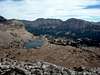
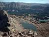
The trail steepens for the next half mile, then levels again for the final 0.75 miles before arriving at the east shore of Ryder Lake, at approximately 8 miles from the trailhead.
There are a number of excellent campsites near Ryder Lake, particularly above the north and east shores. A campsite may also be established at McPheters Lake, which lies approximately 0.3 miles above Ryder Lake to the north-west, but this area is generally more rocky and open, with no forested area surrounding the lake.
Hayden Peak is the prominent peak to the north-west of the two lakes. There is no trail beyond the lakes, but the route to the summit will be quite apparent.
From a base camp at either Ryder or McPheters Lake, the route to Hayden Peak begins by continuing generally westward towards the saddle along the ridge extending south from the summit of Hayden Peak.
The route gains elevation gradually across an open high altitude meadow, until the final steep slope leading up to the saddle, where approximately 500 feet of elevation is gained in just 0.2 miles.
This is the saddle which is reached when climbing the peak from the South Ridge route.
From the saddle turn right (north) and continue along the ridge for 0.6 miles to the summit. This section of ridge will include some scrambing, but can generally be kept at easy 3rd class. A number of scrambling route variations are possible along the ridge.
Essential Gear
No special equipment is required for an ascent of Hayden Peak from this route.Insect repellent is a must until late summer.
Water is plentiful throughout the area - bring a suitable purification method.