|
|
Route |
|---|---|
|
|
40.81000°N / 110.954°W |
|
|
Cross-country hike. |
|
|
Half a day |
|
|
Class 2 |
|
|
Approach
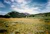
The Gold Hill Road is the access road into this area. This road is suitable only to high clearence, low geared 2wd's or to 4wd's. The Gold Hill Road starts about one mile south of the Whitney Road turnoff and is about 42 miles from Kamas or 36 miles from Evanston. A sign marks the beginning of the road. Follow the sometimes rough road west, staying on the main road towards Gold Hill Pass. Before the road begins to climb to Gold Hill Pass, you will reach Mill City Creek. Park at the large meadow just west of where the Gold Hill Road crosses *Mill City Creek. The large meadow is not too far east of Gold Hill Pass.*Note: There is no Mill City now days; it dissapeared over a centry ago.
Route Description
From the meadow, it is fairly easy to head south to the summit of Gold Hill. The route is rather obvious for the entire distance. This route is less than three miles round trip, so consider exploring the area. After enjoying the views from the summit, consider using an alternate route back to the trailhead. From the summit, head east along the ridge and to point 10,397. Continue along the ridge and descend the steep slope and intersect a 4wd road. Follow this north to the Gold Hill Road, which is followed back west and to the trailhead.