|
|
Route |
|---|---|
|
|
40.76580°N / 110.3778°W |
|
|
Long backpacking trip with some scrambling at the |
|
|
A few days |
|
|
Class 2+ |
|
|
Approach
There are several driving routes to the trailhead, but this is the quickest. A good road map is needed. From Roosevelt, take State Highway 121 north. This is where the elbow in Highway 40 is, right downtown, so the turnoff is easy to locate. Stay on Highway 121 north, follow it as is makes a sharp turn at Neola and heads due east. The highway will reach a "T" and turn south. At the "T", turn left (north) to the town of Whiterocks. From Whiterocks, drive northwest along the paved road. Not long after passing the fish hatchery, will be another junction. Go straight (not left). The road heads north, then east, then north again. At the next intersection, go straight and to the Elkhorn Guard Station. Continue straigh on the Elkhorn Loop Road, up Pole Mountain, and to Forest Road 110 before heading to Pole Creek Lake. Don't take the Elkhorn Loop to Pole Creek Lake, but turn right onto Forest Road 110. If you reach Pole Creek Lake, you overshot the turnoff. Follow Forest Road 110 north for about four miles to the signed (for West Fork Whiterocks Trailhead) turnoff to the left. Instead of turning left, turn right and drive about eight miles to the trailhead below Chepeta Lake. Most of the Elkhorn Loop as well as Forest Road 110 is gravel, but usually in good condition for cars, provided you drive slowly.Route Maps
Route Description
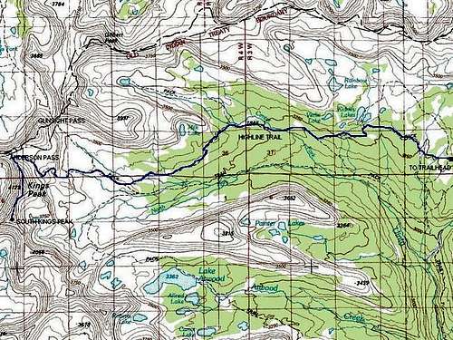
This is a very scenic route, but it is longer than the standard route from Henry's Fork. The round trip distance is 55 miles when coming from the east and Chepeta Lake and much longer still when coming from the west and Hayden Pass. The route will take most people five days, maybe six.From the trailhead, follow the well marked Highline Trail to the west. The trail is fairly well used and easy to follow. The trail follows the dam of Chepeta Lake and then heads west at a gentle grade to beautiful Sharlee Lake (not named on the topo maps, but some forest service maps label it).
The trail continues west at a gentle grade passing to the south of Reader Lakes. Shortly after this the trail climbs above timberline and stays there until dropping down to Brook Lake.
Continue along the Highline Trail while enjoying the good views. You will reach a junction with the trail down to Taylor Lake. This is about 4.5 miles from the trailhead. The lake is rather large and visible below. Keep right and continue west along the Highline Trail. The trail climbs to a highpoint at just over 12,200 feet and is known as Pole Line Pass. The trail climbs steadily and is not very steep for a trail above timberline. Why the location is known as a pass is beyond me, because it isn't a low point between two ridges or peaks. It is simply the highest point the trail reaches on the side of a mountain.
After Pole Line "Pass", the trail zig-zags at a steeper grade down the west side of the mountain. Brook Lake is at the base of the steep section and right at timberline. Fox Lake is another mile beyond and is 10 miles from the trailhead. Also at Fox Lake, there is a junction with the trail to Island and Hoop Lakes Trailhead on the North Slope (yet another variation of the route that is beyond the scope of this page). You will follow the Highline Trail all the way to Anderson Pass.
Follow the Highline Trail west to Kidney Lakes. Always stay on the Highline Trail and avoid the side trails to Davis Lakes, Uinta River, etc. Along the way the trail will pass through huge and spectacular wildflower meadows, which are amoug the largest meadows I've ever seen.
Kidney Lakes are in a nice setting and a great place to hang around. They have great fishing as well. The lakes are another 5 miles from Fox Lake. After Kidney Lakes, the Highline Trail becomes less used.
Continue west on the Highline Trail to the four-way junction at Painter Basin. This is 22 miles from the trailhead. From Painter Basin continue west (straight) staying on the Highline Trail and follow it as it climbs to Anderson Pass at 12,700 feet. This is the standard route on Kings Peak and South Kings Peak.
From Anderson Pass, follow the well used ridge route south to the summit of Kings. Kings is 800 feet above Anderson Pass and has some minor scrambling. From Kings Peak, the route to South Kings is highly visible and obvious.
One thing you have to be very cautious about is that on the return trip you will have to re-climb Kings Peak and descend to Anderson Pass. This means you have to be extra careful with the weather when climbing South Kings since you will actually be on the ridge-top for a much greater distance. Thunderstorms are very common, and if there are any slight signs of one, immediately turn back and don't continue to South Kings!
From Kings Peak, follow the ridge south to the col between Kings and South Kings there is some minor scrambling. Continue on to South Kings, staying on the ridge. The distance from Kings Peak is .8 miles with just over 400 feet altitude loss and gain. There is one very minor false summit along the way. If you're up to it, and if the weather is good, you can continue south along the ridge all the way to Mount Emmons. See this route page for details.


