
-
 36677 Hits
-
 79.77% Score
-
 11 Votes
|
|
Route |
|---|---|
|
|
40.25470°N / 105.6153°W |
|
|
Bushwhack, Moderate Snow Climb |
|
|
One to two days |
|
|
Class 3 |
|
|
Overview
Distance, round-trip: 16 milesElevation Gain: 5,900 feet


This is also an historic climb, for Keplinger's Couloir is the route John Wesley Powell took in making the first known ascent of Longs Peak in 1868.
As always, Leave No Trace, and enjoy the Great Outdoors!
Approach

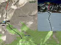
You can follow the Sandbeach Lake Trail all the way to Sandbeach Lake, but when Georg and I hiked this, we turned north (right) off the trail about 0.1 mile before reaching the lake. It is close to four miles of easy hiking to this point.
When you turn off the trail, bushwhack your way northwest through the heavy timber, eventually crossing Hunter Creek at about 11,000 feet. A good GPS is highly recommended for this section of the approach. Along the way, you will have great views of Mount Meeker and it's Dragon Tail Couloir, and eventually Pagoda Mountain, then Longs Peak will come into view.
From turning off the hiking trail, it is about 1.6 miles of bushwhacking to where Georg and I set up camp, at 11,300 feet, just before reaching timberline. Nearby is an unnamed lake, at 11,200 feet, useful for referencing your exact location.
Continue straight uphill into the basin, where you will be able to gawk at the impressive cliffs and slopes of Pagoda Mountain, Longs Peak and Mount Meeker.
Ahead, Keplinger's Couloir is readily visible as the westernmost (farthest left) couloir, going straight up Longs' south face.
Route Description

At the top of the couloir, turn left (west), onto the ledge or snow-shelf (in summer conditions this may be an easy walk-up, but Georg and I encountered a 53 degree snow slope on our March climb). This eventually leads to the Keyhole Route and Homestretch, where yellow and red bullseyes are painted on the rocks, for the final push to the summit.
lavaka - Sep 16, 2005 12:55 pm - Hasn't voted
Route CommentIf you do the route in the summer after mid-June or so, you need only camping gear, i.e. no snow shoes, ice axe, crampons or GPS. Camping at Sand Beach Lake is very pleasant as well and the lake is even suitable for swimming in mid- to late-summer.