
|
|
Route |
|---|---|
|
|
19.03330°N / 70.9833°W |
|
|
Very steep, but non technical route |
|
|
A few days |
|
|
Class 1-2 |
|
|
Approach
There are actually several locations to start this trek. Costanza, Padre las Casas/Las Lagunas, and La Ciénaga are all possibilities. The route from La Ciénaga is the only one that will be descibed here, because it is the route I have trekked.Most people will begin in Santo Domingo. From Santo Domingo, you must make your way to Jaracaboa. Caribe Tours is the bus company that has transport to Jaracaboa. The bus leaves Santiago four times a day from the Caribe Central Bus Station. The journey takes 2.5 hours and cost $5 in December 2004. There are several hotels in Jaracaboa and this is the logical place to arrange a required guide (park service requirement) for Pico Duarte.
From Jarabacoa, you will need to arrange transportation to La Ciénaga. In December 2004 this road was in very bad condition and we had to get out and walk to avoid bottoming out in several places. There is one very narrow bridge that only a small vehicle can cross, and landslides often close the road.
La Ciénaga is at about 1100 meters/3600 feet elevation.
Route Description
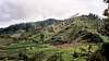
This route is much more strenuous than the standard La Ciénaga Route, but it is more scenic and well worth the effort.The first part of the route is shared with the standard La Ciénaga Route. This first part of the trail is a very gentle and pleasant walk. There are many wild citrus fruit trees along the way which offer a treat, and it is a nice walk through the forest and along the river to Casa Tablones (House of Tablets), which is at about 1270 meters/4170 feet and after 4.5 kms/2.8 miles of walking. After Casa Tablones, the route steepens and the trail climbs steeply along the ridge all the way to El Cruce. Much of the trail is high on the ridge, so carry lots of water.
Signed locations along the trail are Casa Tablones at Km 4.5/Mile 2.8 and elevation 1270 meters/4170 feet, La Cotorra at Km 8.5/Mile 5.3 and elevation 1720 meters/5640 feet, La Laguna (The Lake) at Km 10.5/Mile 6.5 and elevation 1980/6500 feet, El Cruce (The Cross) at Km 11/Mile 6.8 and elevation 2180 meters/7180 feet. This is where the Valle de Tetero Route branches from the main La Ciénaga Route. Turn left on the trail marked for the Valle de Tetero. The trail drops off the ridge and descends steeply down into the valley below. The vegitation becomes very lush and there are some stream crossings. The main path continues on to the Valle de Tetero passing through some beautiful meadows full of wild horses and surrounded by parrot-filled trees. You will reach the newly built cabin/hut which is next to a rushing river. Even though there is a cabin in the valley, you may want to chose to pitch a tent because the cabin sometimes attracts rats. The Valley de Tetero is a real paradise, and is the highlight of the trek. It is located at 1500 meters (4920 feet) and is surrounded by mountains. There are some really cold and deep swimming holes and a nice waterfall if you follow the path up river from the cabin. Downriver are ancient Taino Indian petroglyphs, that are several hundred years old. Look for the sign pointing the way to "Pierda Indigena". There is also a trail following the river down towards Costanza and Padre las Casas/Las Lagunas. After spending the night in or near the cabin, the most difficult part of the trail begins. There isn't much of a trail in places and it is extremely steep. Make sure to have a full water bottle as there is no water available until reaching Agua Fria, which is a steep climb of 1150 meters/3770 feet. The route doubles back through the meadows and the trail fades. Continue accross the meadows and find it on the other side. Now the trail gets really steep! The trail is amoung the steepest (for a trail) I have been on. It climbs very steeply through the forest to Agua Fria where the route joins the standard route from La Ciénaga. Aguita Fria is at 2650 meters/8700 feet and the sorce of the River Yaque South and North, the two longest rivers in the country. There is good water here. From Agua Fria it is 3.5 kms/2.2 miles to the cabin/hut/camping area of La Comparticion. Once again, even though there is a cabin in the valley, you may want to chose to pitch a tent because the cabin sometimes attracts rats.
After spending a night at or near the cabin, most trekkers leave very early the next morning and well before sunrise. This gives you a better chance to hit the summit when the views are clear. Viewing the sunrise is also spectacular. The trail starts off pretty steep and it will be dark, but the required guides will know the way. After 3 kms/2 miles, the trail becomes less steep and reaches a beautiful are known as the Vallecito de Lilis (Little Valley of Lillies). The trail splits here at a minor junction; go left and follow the trail to the summit. The summit is only one km/.6 miles from the Vallecito de Lilis, but is steep in a few places. The route up is just a trail, but the top pitch had some very minor class-2 scrambling to liven things up. If the sky is clear, the views were incredible and you will see all the way to the ocean.
Note: Most people trekking the Valle de Tetero Route will make a loop of this route with the standard La Ciénaga Route.
 |
 |
 |
 |
 |
 |
 |
 |
Time Needed For Climb
At least three days are needed to complete this route through the Valle de Tetero and to the summit. Four days are recommended. The Valle de Tetero itself is the most delightful part of the trek, with nice waterfalls, huge pools, and mountain meadows surrounded by beautiful trees full of colorful parrots and other birds. There are ancient petroglyphs in the valley as well. I would recommend spending a layover day in the valley as it is a real paradise.
Essential Gear
Full camping gear is required. There is a hut in the Valle de Tetero, and another one high on the mountain, but there are rats around. The best way to get a good nights sleep is to bring a tent and camp. There are no stoves at the hut, nor is there bedding available. Bring sturdy footwear that does OK in mud.Note that even though this is in the tropics, the summit area and Valle de Tetero is rather cold at night. We had frost and some ice in the valley because the cold air sinks down from the mountains above.