
|
|
Route |
|---|---|
|
|
38.11580°N / 119.5703°W |
|
|
Hike / scramble / technical rock climb |
|
|
A few days |
|
|
Class 4 |
|
|
Approach
The closest trailheads to Snow Peak are located at the Hetch Hetchy Reservoir in the south, or at Leavitt Meadows from the north.
(1) From Hetch Hetchy, take the trail north to Jack Main Canyon until you reach the PCT. Continue north until you reach the trail for Tilden Lake. Follow the trail on the western shore past the lake until you reach Snow Peak on the northeast side of the lake. (20 miles total)
2) From Leavitt Meadows Pack Station follow the West Walker River trail south all the way to Tower Lake. Continue south over a low use trail over the saddle to Mary Lake. Follow the use trail along the eastern shore past Mary Lake until you reach Snow Peak to the east. (20.5 miles total)
Route Description
I used the north ridge as a descent route. I don't recommend it for the ascent to Snow Peak as there is quite a bit of loose rock and sand on the west face of the ridge. There is also some exposed technical climbing to gain the summit from the north ridge. Therefore, this route description is written for descending.
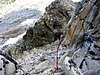
Some exposed Class 5 climbing is required to descend down to a col on the north side of the summit. To aleviate this, I descended down a sloping boulder field on the southwest side of the summit, traversing towards the north on an exposed ledge of loose boulders below the western summit block. Continue to traverse around the corner towards the east. The ledge continues to work its way around under the north side of the summit to the top of the col. The col is steep and full of unstable lose rock and sand, and as such should be avoided. There are small boulders and loose rock covering the ledge, so be very careful with hand and foot placements. You do not want to slip off of the ledge onto the col. There is a small (3') rock wall at the top of the col. Carefully transition off of the ledge and over the wall to safety.
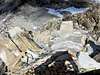
Once at the top of the col, it is necessary to descend the scree slope on the east side of the north ridge in order to avoid a couple of peaklets on the north side of the summit. Descend the scree slope traversing towards the north until you reach the saddle between Snow Peak and Craig Peak. This is pretty nasty terrain comprised of loose rock and dirt, but it is manageable.
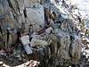
Once at the saddle on the north ridge, descend the gully to the west toward Tilden Creek. The gully is a mix of stable boulders, lose rock, dirt, and patches of grass. As you near the lower part of the slope, you'll have to navigate some patches of Whitebark Pine and Huckleberry bushes, crossing meadows and streams until you reach the Tilden Creek trail on the far side of the valley.
Start elevation: 9,270'
Summit: 10,950'
Elevation gain: 1,680'
Distance: ~ 2 miles
 |  |  |  |  |
Essential Gear
This route can be done without climbing equipment if you are experienced and comfortable with exposure. As always, use your own judgement and turn back if you are not comfortable with the risk.
If you feel the need, a climbing rope and a standard set of hex nuts should be all that is needed to navigate the final ascent up the north / west side of the summit.
 |  |  |
Miscellaneous Info
If you have information about this route that doesn't pertain to any of the other sections, please add it here.