|
|
Route |
|---|---|
|
|
40.14000°N / 107.333°W |
|
|
Hike/Scramble |
|
|
Most of a day |
|
|
Class 3 (class 2+ if you do the bypass) |
|
|
Approach
The trailhead is at a large meadow just south of Ripple Creek Pass. The road over Ripple Creek Pass is usually plowed around Memorial Day and stays open until around Thanksgiving, but each year is different.There are several ways to reach Ripple Creek Pass. There is a road from the south and Trappers Lake, one from the east and Yampa or Phippsburg, one from the northeast and Oak Creek, one from the north and Hayden, and one from the northeast and Pagoda (village) and Hamilton. I know only the road from Hamilton and Pagoda, but very few Coloradoans will be coming from that direction (Craig), so it seems rather pointless to describe the drive. Most people will be driving in from the Trappers Lake or Yampa areas.
Bring the White River Forest Service Map, and park at the meadow just south of Ripple Creek Pass. All raods are in good condition, and can be driven in a car, but 4wd may be needed in bad weather, or ealy or late season.
Note: More detail on driving directions will be added when I drive the other routes.
Route Description
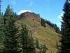
From the trailhead, and the large sign on the north side of the road, locate the trail heading northwest to Snell Park. The trail is open to ATV’s and unfortunately, they have made a big mess in the boggy areas, and where the trail crosses the stream. The trail is easy to follow, but the topo map has several errors. There are more bends in the trail than the map shows, and the trail actually stays on the east side of Snell Park instead of west of the park as the map indicates. Before Snell Park, there are several meadows where you will find some good views of the Marvine Peaks located to the northwest. There are several stream crossings as well.Once you arrive at the huge meadow Snell Park, you will get your first view of Pagoda Peak which sticks up above the thick timber. Continue on the trail to the northwest end of Snell Park. From here, it is probably easiest to continue northeast along the trail until a small highpoint of the trail is reached.
Leave the trail here, and head up the slope to the northeast with a map and compass. There are various game, sheep, and/or cattle trails on the slope which help speed up progress. The only real obstacles are logs to cross over.
Eventually, you will reach the southeast ridge of Pagoda Peak. Follow the ridge to the summit. The route steepens towards the end, and you will have to climb over a cliff-band. The pitch is class 3, but if you head around to the west side of the summit block, you can find a class 2+ route. The summit is not far beyond the cliff band.
Although the map indicates a round trip distance of about 6.8 miles to the peak by following the route on the page, I believe that eight miles is a more accurate figure.