MAJOR TRIP STATISTICS
600 Miles Driving (Roundtrip)
60 Miles Hiking (On-Trail and Off-Trail)
Seven Mountains Summited in Three Days
PROLOGUE
I had been planning to visit the Pasayten Wilderness area and Okanogan National Forest for over a year. The trip was initially planned as a weekend solo adventure until “luck” came my way… my friend and fellow hiker “Gimpilator” Adam broke his right elbow. No, it was not lucky he broke his elbow, and I wish he had not, but the injury prevented him from being able to work and it gave him more free time for hiking. He was not supposed to do any mountaineering that was overly technical during the healing period, so when he suddenly had the opportunity to join me I created a trip plan with that aspect in consideration.
FRIDAY, AUGUST 7, 2009
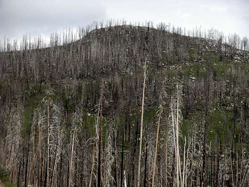
After I got off from work early on Friday afternoon, I picked up Gimpilator at his house. We then drove to Eastern Washington, only stopping for dinner and refueling, arriving at Cathedral Driveway Trail #510A (~5600’ elevation) by 8:30 PM. By 9:00 PM, we began our hike through a burned forest (leftover from wildfires in 2001 and 2003) with post-sunset lighting. We determined it was time to turn on our headlamps within the first 0.5 miles… shortly after I did a near face-plant when I stumbled on a treeroot snag that was hidden by ground-brush. Soon after we turned on our headlamps, we heard voices approaching. Three young men were hiking without any flashlights or headlamps, trying to find their way back to the trailhead. Their water filter had broken, and they had been drinking directly from creeks and springs on their way back. They were determined to continue, so they hurried their pace shortly after we said how close the trailhead was.
By 10:00 PM, we reached an open flat spot (~4700’ elevation) along Chewuch River Trail. We were only approximately 2.8 miles from the car, but glad we at least eliminated a few miles from our overall trek as it could help our hiking success the following day. The campsite we found was wide open and looked like it had been established for a long time. We first looked for a good place to hang our food using trees and small rope, and we found such a location a short walk west towards the Chewuch River. Then it was time to setup our camp. Gimpilator had convinced me before the trip to bivy rather than tent-camp, to save pack weight. The weather forecast looked good for most of the weekend, so I agreed to his suggestion. Setting up our bivy sacks and sleeping bags only took a small amount of time. I was asleep almost as soon as I lied in my bivy-protected sleeping bag.
SATURDAY, AUGUST 8, 2009
We woke up at 4:30 AM the following morning. The outsides of our bivy sacks were each soaked from dew, but the insides of our bivy sacks were each soaked from internal condensation. Fortunately, the insides of our sleeping bags remained dry and warm. We took our time to tear down camp and have snacks for breakfast, before departing by 6:00 AM. We knew we still had 8.2 miles to our next major destination, Tungsten Mine Camp, the planned site for that night’s refuge. During our hike to Tungsten Mine Camp, we passed by several tent-camps. Most of this stretch of the trek was uneventful, except when we passed two men sitting in their sleeping bags who told us they planned to summit Cathedral Peak… They had no map and no idea of which trail they were even currently alongside. After giving the two men basic trail directions, I figured we might encounter them again later during the trip but we never ended up seeing them again. Shortly after Wolframite Mountain came into view along the Tungsten Creek Trail #534, we reached the old site of the Tungsten Mine and spent some time walking around to see the scattered remnants left behind from the long-since defunct mine. We then walked a short jaunt north of the trail junction with Boundary Trail #533 to the original Tungsten Mine Camp (~6750’ elevation), arriving by 10:30 AM.
![Nighttime Bivy Site]() Nighttime Bivy Site
Nighttime Bivy Site
Two cabins still remain at Tungsten Mine Camp: one large cabin with multiple rooms, and one small cabin with one room. After exploring both cabins, and seeing nobody else in the area, we decided to establish ourselves in the smaller cabin. We took out our sleeping bags and bivy sacks, which were still damp, and hung them up on a clothesline inside the cabin to dry. We then spent some time further exploring the immediate area around Tungsten Mine Camp and having some snacks. But we knew our day was not done; it was still morning and we had to start on our next objective: summiting some local peaks.
![Tungsten Mine Camp]() Leftover Mining Remnants
Leftover Mining Remnants loomed large over the north side of Tungsten Mine Camp, and quickly became our first objective. I had already done extensive research regarding the peak and thoroughly examined maps for the summit route with the best chance of success. Using a route description written by famed local climber Bob Dreisbach, I had agreed with his assessment that the western approach would be the least-technical option. Plus, I wanted to make certain the route we would choose would be only YDS Class II with no scrambling, because of Gimpilator’s injured elbow, or else steeper and more direct approaches might have been explored.
![Wolframite Mountain]() Wolframite Mountain Looming Above Mine Camp
Wolframite Mountain Looming Above Mine Camp
Starting by noon, we hiked a little more than a mile west along the Boundary Trail, to the point where the trail bends south towards Apex Pass. At this location, we began ascending northeast, and off-trail, up the western slopes of Wolframite Mountain. The ascent was fairly straightforward; just head up to the summit. We looked across the Tungsten Creek valley at Apex Mountain, and noted how much it reminded us of a volcano like Mount Saint Helens. From the western slopes of Wolframite Mountain, nearby Apex Mountain almost has the appearance of a volcano with a top and side blown-out from a past eruption and a cinder cone inside. In reality, Apex Mountain is not a volcano, active or extinct, and the “cinder cone” on its north side is only a very large hill formed from past avalanches. But it was still an interesting perspective to view the peak. We reached the summit (8137’ elevation) of Wolframite Mountain by 1:30 PM. We spent a long time on the summit looking at nearby peaks, including Apex Mountain, Amphitheater Mountain, and Cathedral Peak. It also fascinated us that we were only one mile south of the Canadian border.
![Apex a Volcano?]() Apex Mountain, As Seen From Wolframite Mountain
Apex Mountain, As Seen From Wolframite Mountain![Wolframite Mountain Summit]() Gimpilator Approaching Wolframite Summit
Gimpilator Approaching Wolframite Summit![At Wolframite Summit]() At The Wolframite Summit
At The Wolframite Summit
Our next destination was
Apex Mountain. Our plan was to hike back to the Boundary Trail and continue south to Apex Pass before ascending the west slopes of the mountain. During our descent of Wolframite Mountain, I grew concerned about an apparent storm system suddenly lingering in the valley between the two peaks. Gimpilator said it did not look like anything that might affect our summit efforts on Apex Mountain. Then, as we approached Apex Pass, we could hear a thunderstorm in the distance to the east. It appeared that storm system was moving west, rather than the normal direction (east), and was swirling in the valley, but again Gimpilator was not concerned. Initially, his thoughts were correct and we were able to ascend off-trail from Apex Pass up the western slopes of Apex Mountain without the storm system above us. However, clouds seemed to be following us up the slopes and ruining views of nearby peaks. The moment we reached the true summit (8297’ elevation) of Apex Mountain, at approximately 3:40 PM, a hailstorm started. Gimpilator still thought the storm would not be anything major, and he predicted the hail would stop within a couple of minutes. Unfortunately, that is not what happened because it was a sustained 45-minute long(!!!) hailstorm, but at least a thunderstorm never materialized on the peak. As we began our descent, the hail hit harder and larger with each passing minute. The weather pattern changed from hail drops to hail stones by the time we reached Apex Pass. We briefly sought refuge in a small grove of trees, but once it appeared the storm would not be stopping anytime soon, we jogged down the Boundary Trail back to Tungsten Mine Camp. The hail stopped shortly thereafter.
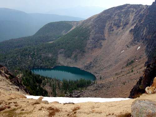
![Tungsten Lake]() Tungsten Lake
Tungsten Lake![Gimpilator Ascends Apex]() Ascending Apex Mountain
Ascending Apex Mountain![Triumphant On Apex]() Gimpilator On Apex Mountain Summit
Gimpilator On Apex Mountain Summit
We each placed our sleeping bags, which were now completely dry, on wooden bed planks located along the north wall on the inside of the cabin. After changing into dry clothes and lying down for a short time, we were hungry for dinner. Gimpilator went down the trail to filter some water to be used for our meals while I stayed in the cabin preparing my Jetboil cooking system. Only a few minutes after Gimpilator left the cabin, the front door opened. A man named Dave was standing there, dripping wet from the storm. He had brought his sleeping bag and some other gear, to spend the night in the cabin. Apparently, he was tent-camping at Apex Pass but the hailstorm had thoroughly soaked both the outside and inside of his tent. He said there was standing water inside his tent, so he retreated from the tent to the Tungsten Mine Camp only a few miles away because the cabins provided dry shelter. Dave said he had lived in nearby Oroville for many years and had never seen a hailstorm quite like the one that hit the area. Although the large cabin had nobody staying in it, Dave opted to stay with us in the smaller cabin by sleeping on top of the bunkbed in it. Shortly after Dave’s arrival, two hikers passed by en route to Apex Pass. Then, only a few minutes later, another man came up to the cabin, hiking the Boundary Trail as part of the Pacific Northwest Trail route, and he decided to spend the night in the larger cabin by himself. When Gimpilator returned to camp, he was shocked not only to see another camper in the cabin but also other hikers on the Boundary Trail. I cooked our meals, we ate them, we socialized with Dave and the other man, and then Gimpilator and I played a quick game of horseshoes outside before going inside the cabin to play rummy until it was time to go to bed.
SUNDAY, AUGUST 9, 2009
When we woke the next morning, I looked outside and saw some storm clouds still lingering in the valley. We originally planned to hike approximately 20 miles that day in the Pasayten Wilderness, spending the night bivying as we had the first night. However, considering how damp our gear got the first night (which was a clear night), as well as how intense the Saturday storm was, I revised our plans. I decided it might be best to do more exploring in the immediate area and use our cabin as a “base camp” for one more night, and Gimpilator agreed. Fortunately, I had already prepared for such alternate plans by researching nearby peaks and points of interest. We set our sights on
Bauerman Ridge, located several miles east of Tungsten Mine Camp. We began our hike by 7:30 AM.
![Bauerman Ridge]() Bauerman Ridge
Bauerman Ridge
After we hiked beyond Scheelite Pass, we reached a great viewpoint of Bauerman Ridge where the highpoint was located due east of us. However, despite having read some literature suggesting that off-trail ascent route, it appeared quite steep and possibly involved scrambling (which we were trying to avoid because of Gimpilator’s broken elbow). Upon reviewing my map and GPS, I believed it would be least technical to continue along the Boundary Trail until we reached the southwest side of the ridge. It appeared that location would be the shortest off-trail route to the ridgetop, albeit a longer hike overall. The steep southwestern slope of the ridge did not require any scrambling, and offered fantastic views of Windy Peak, Remmel Mountain, Apex Mountain, Amphitheater Mountain, Cathedral Peak, and Wolframite Mountain. Once on the surprisingly flat and barren ridgetop, we hiked northwest along it, passing by several false summits until reaching the rocky true summit (8044’ elevation) of Bauerman Ridge by 10:20 AM. The final slope was solid rock and required a minimal amount of scrambling, which Gimpilator did using only his left (“good”) arm. Scheelite Lake (at the base of the cliffs due north of the summit) was a gorgeous lake to look down at, and the sheer rockfaces (northwest of the summit) were very impressive to see.
![Apex, Amphitheater, Cathedral, Wolframite]() View Of Apex, Amphitheater, Cathedral, and Wolframite...
View Of Apex, Amphitheater, Cathedral, and Wolframite...![Bauerman Ridge Summit]() Me, On Bauerman Ridge Summit
Me, On Bauerman Ridge Summit
By the time we reached the summit, an apparent storm system had moved over the mountain. The wind was blowing briskly and the temperature dropped considerably. We knew this might turn out to be a shortened hiking day, so we opted to walk south back down the ridgetop and head east to nearby peak
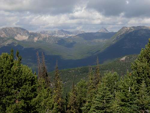
Teapot Dome. While walking along Bauerman Ridge, we found numerous fresh bighorn sheep tracks and excrement, and we kept feeling like they were hiding behind some of the large rocky hills on the ridgetop. As we turned to begin our descent down the eastern side of Bauerman Ridge, we stopped to look into a deep natural chasm. We then continued down the slopes to the flat plateau saddle between Bauerman Ridge and Teapot Dome. A small, unnamed lake is located on that plateau, and if the weather had been hot I surely would have dived into its cool refreshing water. We then passed by the lake and hiked up the western slope of Teapot Dome to its rocky summit (7608’ elevation), arriving by 11:20 AM. The weather on Teapot Dome was noticeably better than we had experienced on Bauerman Ridge. It was as if the 3.5-mile long (and 400’ taller) Bauerman Ridge casted both a rainshadow and a windshadow upon Teapot Dome. We spent 30 minutes on the summit, eating snacks and socializing. We were satisfied to have summited two of the top 30 highest peaks (Apex Mountain and Wolframite Mountain) in the Pasayten Wilderness as well as one of the top 20 most prominent peaks (Bauerman Ridge) in the Pasayten Wilderness. In addition, we had summited one other peak (Teapot Dome), and all in less than 2-1/2 days and without much technical climbing needed. We would have liked to have also attempted some of the bigger peaks (such as Cathedral Peak and Amphitheater Mountain), but Gimpilator’s elbow was still healing and we knew those mountains can be attempted during future trips. Moreover, we did not mind summiting the four peaks we did because they seldom get summited and we got to fully enjoy each of them without disturbances from other people.
![Teapot Dome]() Teapot Dome
Teapot Dome![At Teapot Dome Summit]() Taking A Break At Teapot Dome Summit
Taking A Break At Teapot Dome Summit
After our summit break on Teapot Dome, we headed down to the Boundary Trail. Shortly after hiking west of Scheelite Pass, we encountered a group of hikers heading to Apex Pass who had spent the night near Teapot Dome. They were planning to meet up with Dave, our cabin roommate from the previous night. When I told them he spent the night in the same cabin as we did at Tungsten Mine Camp, they looked confused. A few of their facial expressions were priceless. They seemed to be trying to think how we could have spent the night with Dave at Tungsten Mine Camp (which was still ahead of them, to the west) but we encountered the group from behind them (from the east). One woman even quietly commented to another party member that our packs looked too small for being in the backcountry. The group did not realize we had left most of our gear in the cabin, then ascended off-trail over Bauerman Ridge and down to Teapot Dome, and then regained the Boundary Trail and headed back towards camp. We had essentially circled around their group, unknowingly to anyone while it was happening, which made the scene a little funny.
OF MICE AND MEN
As we continued back to the cabin, we encountered Dave on the Boundary Trail looking for his expected group. He mentioned to us that a hiking couple had been in our cabin and tried to take our spots, but that he told them those spots were already taken by us. When we returned to the cabin, Gimpilator found traces of a few tiny food crumbs (unbeknownst to me) on his sleeping bag, probably leftover from those hikers, but my sleeping bag looked undisturbed. Gimpilator swept the tiny crumbs off his bed and lied down.
Sunday evening was our second night in the small cabin at Tungsten Mine Camp. Dave was still at the site but had moved all of his gear into the larger cabin while his group (which we met on the Boundary Trail) proceeded to Apex Pass for tent-camping. I had moved my sleeping bag and from the lower bed against the north wall to the top bed of the bunkbed, where Dave had slept the night before. The bunkbed instantly felt more comfortable for me. As we started to fall asleep, Gimpilator saw a small deer mouse scurrying in and out of the cabin from under the door. Once we knew the mouse was outside, I placed some boards underneath and in front of the gap between the floor and the door, to help prevent any visitors from going through that spot. I made certain none of my gear was on or near the floor, as a precaution. Within minutes, I could hear mice crawling in the middle of the double-walled sides of the cabin. I could hear them climbing through the walls, even seeing their shadows in the walls near my bunkbed on occasion. They seemed intent on entering the cabin, despite our food being stored outside the cabin door in a hanging box. Then Gimpilator mentioned to me about the tiny crumbs on the floor, and suggested the mice could probably smell that food. However, we were semi-confident we had found the main entrance that mice could squeeze through to enter the cabin, and we each soon fell asleep. But hearing the mice in the walls near me was quite a surreal experience.
At approximately 2:00 AM, I was halfway awake. I suddenly heard a different kind of scurrying sound. It was as if the scurrying was above my head! I heard “chicka chicka chicka” (scurrying noises) from above the ceiling heading towards the north side of the cabin, then a “THUD!” sound, then loud shrieking and scurrying noises heading towards the door, and then another minor “thud”. I turned on my headlamp, as did Gimpilator. Apparently, one of the deer mice had crawled all the way up the walls to the attic area above the ceiling, then across the attic, then fell through (or jumped through) a hole in the ceiling and landed on bed boards… the ones I had slept on the previous night!… and freaked out so much the mouse ran for its familiar cabin exit (i.e. the door) only to run into the boards I placed there. The mouse then hid behind some tools in the corner closest to the door. Gimpilator and I did not want to get up to try to let the mouse outside, as that attempt might take a while and with the surrounding darkness other mice actually might get brought into the cabin. So we were willing to live with one mouse. Gimpilator was especially unconcerned about the mouse, despite leaving his boots on the floor and sleeping on bed planks only a foot or so above the floor. However, surprisingly, the sounds of other mice scurrying in the walls mostly subsided while the one mouse was in our cabin. During the rest of the evening, I would periodically turn on my headlamp and check on our little “friend” in the cabin. At one point, I watched him crawling on the second level of the cabinets near the sink. The sink has not worked in years, but piping still leads straight down from it that can be seen because the cabinets have no doors. When I shined my headlamp light on the mouse, he darted over to the sink piping, reached out, and SLID down the pipe like a firefighter. I woke up Gimpilator just to tell him about it. We then named the mouse “Evel Knievel” because of his various cabin antics that night.
![A Mouse Named Evel Knievel]() "Evel Knievel"
"Evel Knievel"MONDAY, AUGUST 10, 2009
The next morning, we packed our gear and headed back towards the car. While en route, we wanted to take a side-trip to Windy Peak. However, it would involve approximately 4000’ elevation gain in a six-mile span from the appropriate trail junction we would need to take, and a new storm was brewing above us. We decided to save that summit attempt for a future hiking trip in the area. It turns out it was a good decision; a big storm was already hitting Windy Peak by the time we reached the car, and we would have been in the middle of the storm had we chosen the side-trip option. Instead, we opted to take a break at the car, change our clothes, and then head south towards Tiffany Mountain. While en route, we did a couple of minor hikes:
Corral Butte (which had better than expected views) and
Thunder Mountain (which was a nice off-trail ridge hike through burned forests and meadows).
![Corral Butte]() Corral Butte
Corral Butte![Thunder Mountain]() Thunder Mountain
Thunder Mountain
We then passed by Tiffany Mountain, as Gimpilator had already summited that peak, and opted to summit
Clark Peak. The hike to Clark Peak was on a trail for the first half of the hike, and then off-trail for the second half of the hike. Although my map shows the trail as “difficult for stock”, we saw cows all over the mountain slopes and found cow-pies all over the trail. We even found cow-pies on the upper slopes of the mountain, away from any trails. We reached the summit of Clark Peak (7890’ elevation) by 5:30 PM, our seventh mountain summit attained in less than three days. Clark Peak was a great way to finish the day, as it had the most elevation gain and most route-finding skills needed of any of the seven peaks we had summited. That night, we parked at Baldy Pass. Gimpilator had bivy outside of my car, while I opted to sleep in the comforts of my backseat.
![Clark Peak]() Clark Peak
Clark PeakTUESDAY, AUGUST 11, 2009
Fortunately for Gimpilator, no rain fell that night. However, some rain drizzle began at 5:30 AM so we got ready to leave. We considered doing some other hikes in the area, but then decided to do some summit attempts closer to Mazama and North Cascades National Park while on the way home. Unfortunately, the forest roads leading towards the peaks we wanted to hike were temporarily closed due to mudslides. Rather than continue driving around looking for summits, we stopped for a while at Washington Pass, then ate a buffet lunch in Sedro-Woolley, and then headed back home, arriving in the early afternoon.
But despite not doing any summit hikes during the final drive home, we still considered the trip a success and we have newfound respect and admiration for the Pasayten Wilderness and Okanogan National Forest.


Comments
Post a Comment