
-
 38394 Hits
-
 95.27% Score
-
 52 Votes
|
|
Area/Range |
|---|---|
|
|
37.61423°N / 13.93616°E |
|
|
Hiking, Mountaineering, Scrambling |
|
|
Spring, Summer, Fall, Winter |
|
|
10958 ft / 3340 m |
|
|
1 - Overview
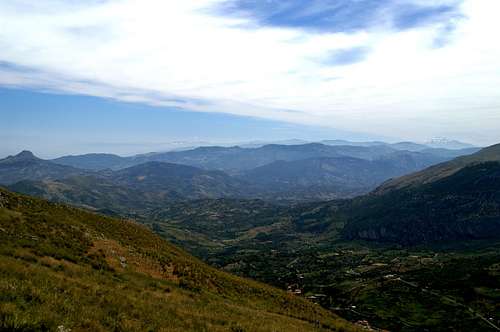
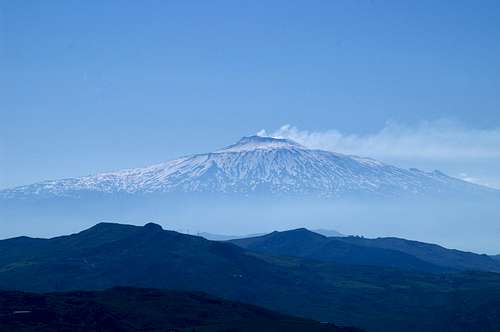 Monte Etna seen from Monte Sambughetti Monte Etna seen from Monte Sambughetti |
With more than 25000 square km Sicily is the largest island of the Mediterranean and thanks to Europe’s largest active volcano, Monte Etna, it is also the highest one. But if you ask yourself what you associate with the name Sicily, the other mountains of the island will not feature very highly on the list. Most people – as I have come to know when preparing for a two week vacation – seem to think first of the Mafia, vendetta, theft and other insecurities. Some may know about the rich cultural heritage dating back to the old Greeks when Syracuse was one of the mightiest and most important cities of the Mediterranean (which was synonymous with the world at that time).
But Sicily definitely is a mountainous island. The long chain of the Apennino, which runs through the whole of Italy, comes to a sudden close at the Strait of Messina, where it drops into the Ionian Sea only to rise again on the other side of the strait. It runs from East to west, first as a set of mountain ranges but finally loses itself in the highlands of western Sicily. Quite contrary to the expectation volcanic rock can only be found in the direct vicinity of Monte Etna while almost the complete remainder of Sicily’s mountains is made up from limestone rock. For most parts the formations are karst-like – high plains, sudden dropoffs, caves and dolines, all overgrown with the eternal Macchia. The mountains are very solitary - you hardly ever meet anybody on them. Moreover trails are scarce and are hardly maintained.
The interesting mountain ranges all are aligned on the north coast of Sicily, rising almost directly out of the sea. To the east, north of Monte Etna, you find the Monti Peloritani, further east the Monti Nebrodi – the largest range, still further east Le Madonie, Sicily’s highest mountains (apart from Monte Etna). The western highlands resemble hills – but hills with impressive vertical faces rising out of them – Monte San Calógero, Rocca Busambra, Pizzo Mirabella to name a few of the most striking ones. In the centre and the south of the island you find the Monti Iblei, Monti Erei and Monti Sicani. All are rather highlands than real mountain ranges. The Monti Iblei in the south-east are home to Sicily’s finest canyons.
Exploring Sicily on foot definitely is rewarding – beautiful landscapes which all can be hiked in complete lonesomeness. However you have to keep a few things in mind if you plan a stay on the island in earnest:
- You are close to Africa – even in May the sun burns down vertically with temperatures way above 30°C. Hiking is possible but always remember to bring enough water!
- There are trails, which have been established several years ago. However, they are not regularly maintained which means that signposts have fallen or vanished and path-finding skills are required.
- Don’t go if there is fog! The mountains (especially the Madonie) are almost featureless, they are remote and often canyons and chasms open up before your eyes. If surprised by clouds during one of your rambles take extreme care. Having a GPS receiver definitely helps a lot since you’ll be able to retrace your steps.
- Everything but wide dirt roads are overgrown with macchia. You’ll be forced through thickets of gorse, holly, blackberries, thistles and the like. Long pants should be mandatory but who will wear them in the intense heat?
- There appears to be an eternal cloud of haze (and/or smog) hanging above the island, helped by the Sicilian habit of burning weeds. In my experience, you must be extremely lucky to have clear days but maybe that was just my poor luck.
- Whatever people tell you about theft on the island – don’t worry. As you came to climb the mountains in remote areas you are quite safe. The big cities are a different matter, though.
2 - Sicily on SP
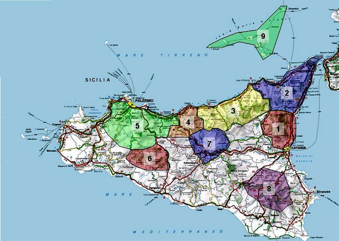  |
Together with the map posted above the following list is supposed to give you an overview over the mountains submitted to SP and where you will find them on this page. The map is interactive so that clicking the numbers will direct you to the section on this page. Since I actually have not started yet with the pages you will find here the shape of things to come. At the moment I’m not even sure if I will submit all the indicated pages but time will tell.
- Monte Etna – Mongibello (this page)
- Monti Peloritani
- Monti Nebrodi
- Le Madonie (this page)
- Western Sicilian Highlands
- Monti EreiCoste di San Antonio
- Monti Sicani
- Monti Iblei
- Isole Eólie
3 - Monte Etna – Mongibello
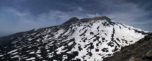 Summit Craters of Monte Etna seen from the Pizzi Deneri
While you might consider Monte Etna (which has its own page on SP) as a single mountain, its sheer size and the fact that it possesses some 200 side craters makes it worthy to be considered as a whole range. Monte Etna, or Mongibello (Monte (Italian) = Djebel (Arabic) = Mountain) as it is called locally is the tallest mountain of the Mediterranean and reaches 3342m currently. Its circumference is some 140km and it is the most active of Europe’s great volcanoes. Indeed Stromboli on the likewise called Island to the north of Etna is certainly more active as it spits out lavas incessantly but its size of less than 1000m doesn’t give it a place among the great volcanoes.
On clear days Monte Etna can be seen from almost any higher place on the island of Sicily. Thanks to the haze at its base it seems to hover above everything else. Due to volcanic activity the standard route to the mountain (cable car and jeep taxis), which starts north of Nicolosi to the south of the summit can be closed so it pays to keep informed on the current events before considering a climb. The eastern route from Rifugio Citelli is very tough as you have to gain 1700 metres of altitude on cinder and ash.
4 - Monti Peloritani
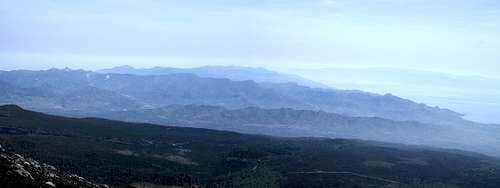 Monti Peloritani as seen from the slopes of Etna through the haze
The oldest mountain range of Sicily is located north of Monte Etna at the north-eastern tip of the island. It rises directly out of the Strait of Messina and forms a single ridge line running from north-east to south-west. It is composed of brittle limestone rock and summit elevations hover around 1000m – 1350m. Landmark of the mountain range is Rocca di Novara, a limestone tower which dominates the whole range. The Monti Peloritani all offer excellent views thanks to their proximity to Monte Etna, the Strait of Messina and the Isole Eólie to the north.
5 - Monti Nebrodi
 Monti Nebrodi and Etna as seen from Monte Grotta Grande
The Monti Nebrodi are a large mountain range, stretching along the northern coast of Sicily between Monte Etna and Santo Stefano di Camastra. It is a cultivated range with lots of arable land and quite a number of mountain villages in between. Most of the summits are covered by dense forests, a scarce thing on an island which was already famed in Roman times for having been the timber source of the Roman fleet. There are some worthwhile mountains in the range but in the long run you go there rather to escape the heat than to climb any mountain. When not covered by trees the mountain tops offer close views of Monte Etna and the Isole Eólie.
6 - Le Madonie
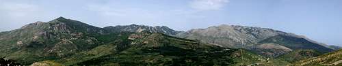 Le Madonie as seen from Pizzo Catarinecci
If it weren’t for Monte Etna Le Madonie would contain the highest mountains of the island of Sicily. Pizzo Carbonara, the highest one, possesses several equally sized summits, the highest of which reaches 1979m. The range is composed of limestone summits, all of which have karst-like summit plateaus. There are caves and canyons but the most distinguishing features are dolines, hollows which were created by imploding caves and which accumulated enough soil to form beautiful meadows. The area is arid since all water vanishes quickly to the inside of the rocks only to spring out again at the base of the mountains.
The Madonie is composed into several subgroups which all are separated by profound valleys. Interestingly – though the mountain tops are flat – they form impressive vertical walls on some of their sides. For instance, the village of Isnello, which is located rather centrally in the range – is wedged in between the Carbonara west faces and the Monte Grotta Grande East face. You definitely need path finding skills to reach the summits as the mountains are almost featureless. Fog can be a real danger up there.
7 - Western Sicilian Highlands
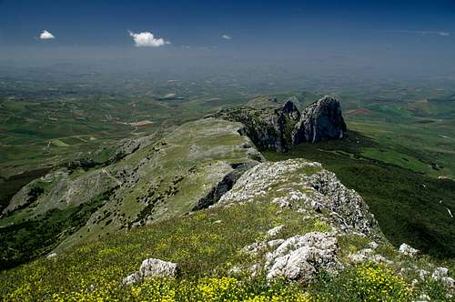 Rocca Ramusa as seen from Rocca Busambra
The Madonie is the westernmost “real” mountain range – it drops off into the Valley of Fiume Grande. On the other side of the river a hill-like highlandrises, which stretches far west to Castellamare. Here you find a cultivated landscape out of which – here and there – impressive near vertical rock faces rise. The most important are Rocca Busambra – a long 1660m high limestone ridge with vertical north faces and Monte San Calógero a solitary standing mountain, which rises drectly from the sea south-west of Termini Imerese. The rocks are there for you to explore but you have to take into account the macchia. Bring long pants, bring a knive to cut brambles and you are rewarded with great views and experiences.
8 - Monti Sicani
The Monti Sicani Are located in the south-west of Sicily in the triangle between Corleone, Sciacca and Agrigento. This is a mountain range, which reaches between 100m and 1450m in height with Monte Rose (1436m) as its highest summit. Like everywhere else on the island, the mountains are made up from limestone and cut through by deep river valley. Two areas have been set aside as nature preserve, the “Riserva Naturale Monte Genuardo e S. Maria del Bosco” and The “Riserva Naturale Monti di Palazzo Adriano e Valle del Sosio”.
9 - Monti Erei
Located in the centre of the island with the provincial capital of Enna at its heart the Monti Erei are a large mountain range, most of which is cultivated, arable land. The highest mountain is Monte Zimmara (1333m) in the north close to the border of the Monti Nebrodi. The range does not sacle high as hiking destination.
10 - Monti Iblei
The Monti Iblei are located at the south-eastern end of Sicily between Siracusa, Ragusa and Lentini. This is one of the oldes cultural areas of Sicily which means that antique ruins can be found “everywhere”. The Monti themselves resemble more of a high plateau at an elevation of about 600m – 800m and is best known for the narrow canyon of Cavagrande del Cassibile, which tourist guides dub Grand Canyon of Sicily. The highest mountain of the range is Monte Lauro (986m)
11 - Isole Eólie
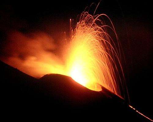 Volcanic activity on Stromboli
In ancient greek legend these islands were the home of the wind god Aiolos. Moreover the island volcano was home of Hephaistos, the limping god and smith, husband of Aphrodite. In reality the islands are all of volcanic origin, “lined up” along the “Street of Volcanoes” between Monte Vesuvius and Monte Etna. Some of them are still (or constantly) active like Stromboli, some are dormant (like Vulcano) but most are extinct. The largest island is Lipari, which is also the most popular one among tourists.
| Name | Area | Highest Mountain | Coordinates | Thumbnail |
| Alicudi | 5.2 km² | Filo dell’Arpa (675m) | 38°32'N, 14°24'E |  |
| Filicudi | 9,7 km² | Fossa Felici (774m) | 38°35'N, 14°34'E | |
| Salina | 26,8 km² | Monte Fossa delle Felici (961m) | 38°34′N, 14°50′E | |
| Lipari | 37 km² | Monte Chirica (602m) | 38° 28′N, 14° 57′E | |
| Vulcano | 21 km² | Monte Aria (500m) | 38° 24'N, 14° 58'E | |
| Panarea | 3.4 km² | Punta Cardosi (402m) | 38.63N, 15.07E | |
| Stromboli | 12.6 km² | I Vancori (924m) | 38,79N, 15.21E |  |
12 - Getting There and Accommodation
12.1 By Plane
There are three major airports, one at Palermo in the north, one at Catania in the east and one at Trapani in the west of the Island. To my knowledge only the Catania and Palermo airports are served by international charter carriers, while Trapani is a national airport.
12.2 By Ferry
There are quite a number of ferry ports on the island the most of which serve traffic for the surrounding islands. Major ferry ports are Messina (obviously due to its proximity to the “continent”, Calabria on the other side of the strait), Catania, Palermo and Trapani. The following table gives an overview of ports and destinations
| Port | Origins |
| Messina | Reggio di Calabria, Isole Eólie |
| Catania | Napoli, Livorno, Malta |
| Palermo | Livorno, Genova, Napoli, Cagliari (Sardinia), Isole Eólie |
| Trapani | Cagliari (Sardinia), Tunis, Isole Egadi |
12.3 - Accommodation
You can quite easily find hotel rooms and apartments everywhere on the coasts. All European travel companies offer accommodation so a visit to your nearest travel office will find you some. In the mountains themselves accommodation is much harder to come by. Since camping is not allowed (see red tape) you have to ask at the local inns. Moreover there some farms which offer “agritourismo” though on Sicily this often means only food and no rooms.
12.4 - Camping
There are quite a number of campgrounds along the coast so everything applies that has been said in the accommodation section. It pays to make reservations if you plan to stay during the holiday season. Free camping is not tolerated (see red tape)
13 - Red Tape
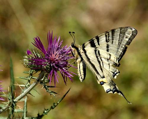 Iphiclides podalirius
The good news is that there is virtually no red tape on the island. Most mountainous regions have been set aside as parks (state, national, natural) so that camping or the collection of plants and animals is not allowed. Apart from the parks most of the land is owned privately and often fenced in. Sicilians don’t have problems with you crossing their land but please close fence gates after you.
14 - Weather Conditions
Sicily is located very close to northern Africa (Marsala on the west coast is closer to Tunis than to any place on the Italian mainland), thus temperatures can get very high. March, April and early May are the best months if you plan to hike the mountains, the winter can be wet, the summer scorchingly hot. Here are a few weatherunderground links to the principal towns on the island.
15 - Maps & Books
15.1 - Maps
Unfortunately, there are no current topographic maps of Sicily. The best are reported to be more than 50 years old and probably are the same as the basis for the digital maps of http://www.pcn.minambiente.it/GN/index.php?lan=en.
As a workaround you can use street maps for general orientation together with a good guidebook (see below). The most accurate maps are scaled 1:200000, sometimes detailing everything down to forest and dirt roads through the mountains. I settled for
- Sizilien
Shell Generalkarte
1:200000
Mairs Geographischer Verlag
ISBN: 3-8297-2080-7
15. 2 - Books
Since there are no good topographical maps of Sicily you should take care to get a good guidebook. The one I used is in general excellent. However it was issued in 2002 and in the 4 years that lie in between trail conditions have changed decidedly. Especially at Pizzo Mirabella in the western highlands we had quite some trouble to find the described routes. The book is available in German and English.
- Sizilien / Sicily
M. Omidvar
Rother Verlag
ISBN:
3-7633-4266-4 (German)
3-7633-4813-1 (English)