
|
|
Route |
|---|---|
|
|
Hiking, Mountaineering, Bouldering, Scrambling |
|
|
Winter |
|
|
Expedition |
|
|
Class 3 |
|
|
Very hard |
|
|
III |
|
|

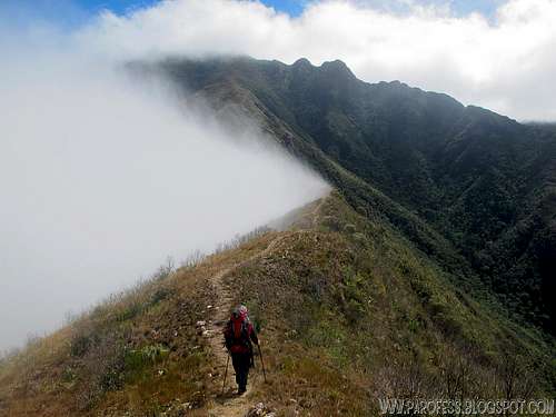
Informative view of the second part of the traverse

Same image, no labels.
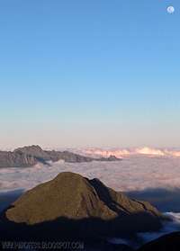
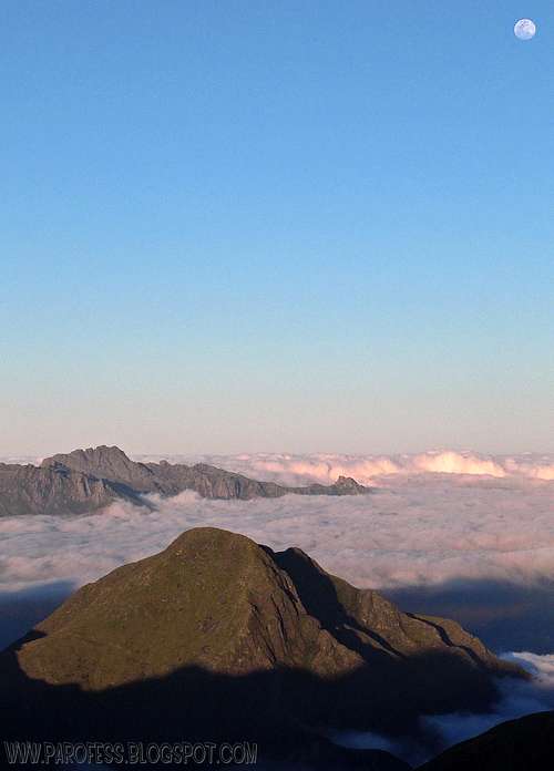
Serra Fina, or Sierra Fina, is a section of Serra da Mantiqueira, on the triple border São Paulo, Minas Gerais and Rio de Janeiro states. The Sierra gets its name because of a outstanding feature, its ridges are so narrow, sometimes less than a meter along its entire length of the crest. Also, Sierra Fina has a major topographical unevenness of the Brazilian territory (above 2.000 m, one of the biggest here), and it protects extremely important data for geology, geomorphology, paleoclimatology and botany among other fields of scientific research, and by doing so it becomes a place of high scientific value of these fields. Its tropical altitudes are biological islands with unique climatic conditions. It lies in an area of APA - (Área de Proteção Ambiental/ Environmental Protection Area), a place virtually untouched because of its difficult access. Its vegetation consists of Atlantic forest and pine forests, with patches of these remaining forests, and high altitude grasslands on its highest peaks.
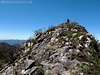
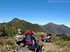
The Sierra Fina traverse is considered one of the 10 most difficult traversers in Brazil, some say even in South America (I doubt that). Also considered to be one of the 5 most beautiful traverses here in Brazil (that I can believe!) along with Sierra dos Órgãos traverse. The best way to experience this paradise is undoubtedly to face the challenge, which will serve you as a good training for larger traverses accross Patagonia and Cordillera Blanca. There are several peaks, most of them unnamed, and deep canyons, privileged view of Paraíba Valley, South of Minas Region. Not to mention the famous almost erotic view of Itatiaia National Park and its brazilian star Agulhas Negras Peak, best viewed from the summit of 3 Estados Peak.
The traverse can be made from the traditional starting point, Passa Quatro county, or the opposite direction, starting at the Pierre Farm close to Itamonte county. The full route takes on average 4 days, but challenges stronger hikers to do it in fast 3 days. The total of the traverse distance is around 34kms (21,15 miles). It doesn't look too much, but the altitude gain will be in total around 3.300m (10.827feet), and you'll have to descent the same at the end. All that with a heavy load on your back of at least 20kg.
It's an adventure for experienced trekkers, is not recommended for beginners. The trail has sections on altitude grasslands, rocky fields where there are some scrambling with some difficult paths, with much forests of Carafá (a type of thin bamboo, which makes it very difficult to hike since it keeps getting stuck on your backpack), and the most difficult, it’s necessary for several times to traverse vast fields of Capim Anta (aka Capim Elefante), a type of wood that can grow up to 8 feet tall and it can cut your hands just like a razor blade. In some places, the trail simply disappears and you can’t see your partner even if he is just a couple feet away from you.
Water is also very low in any way, so because of that people carry 5 or 6 liters hiking all the time. The exception is the area around Pedra da Mina, as the name suggests, it has four abundant streams of water, running at altitudes up to 2.570 meters high. For these and other reasons, to make this traverse you have to know basic navigation skills, or go with someone who already knows the region.
Getting There
The start of the trail is in the Passa Quatro county. From Rio de Janeiro , around 320 km and São Paulo, the same. The mountain is far of any county around it. By the way , you must be with someone who knows the trail for your own security to climb or camping in this region. However, from Dutra road (BR-116) you take some views of the range.Once you get to Passa Quatro, look at the main square for transport all the way up to Toca do Lobo (Wolf's nest). At the bus station there is plenty of taxis, they can drive you up to 1.300m high. With a 4x4 only you'll get to 1.570m high where the Wolf's nest is.
Route description day 1
Day 1: This day you will leave the 1.560m mark to reach the highpoint of 2.500m high, the top of Capim AMarelo Peak. The trail is very well marked, most of the time you will hike a narrow ridge so there's no room for mistakes, just follow the trail up. This first day can take from 3 to 6 hours hiking up with all your heavy load of tent, gear, and water. You must hike up with at least 5 liters this first day.  |  |  |  |
Route description day 2
Day 2: You must hike this day, even more. You will go down from Capim Amarelo summit to the altitude of around 2.250m high, passing by three more campsites, not including its summit. The traverse is marked by plastic ribbons every 50 yards or so. Follow it (or use the GPS trek log). Hike the rocky ramp of Melano Peak till you get to its main ridge at around 2.510m high. From there, go up and down all its summits, four of them, untill you get to the highest and fifth one, the summit of Melano Peak, at 2.566m high. From there, you'll see your objective for this day, Pedra da Mina (Mina Rock), the 4th highest brazilian peak. Follow the dozens of cairns you'll see on the opposite descent of Melano summit. You'll enter a huge valley now but don't worry, you can see whats around you all the time, after all, it is a flat valley just like Ruah Valley.Keep looking at the cairns and you will reach a river, get water! But not so much, you need just the ammount to drink on your way up to Mina Rock, highest and most important mountain of the entire traverse. After that you have around one and a half hours to get to the top of Mina Rock. Your day ends here. Set up yout tent and cook your dinner.
Expect to be hiking for 5 to 8 hours this day!
 |  |  |  |  |  |

Route description day 3
Day 3: Get ready to be tired. This day starts light, descent Pedra da Mina to Ruah Valley. Easy and you'll do it in no more then 25 minutes. But this is the easy part...As soon as you get to the bottom of the Valley you'll be at the camp, which btw is the coldest place ever to camp on Sierra Fina.Follow green ribbons along the high vegetation (sometimes over 7 feet high) to the river, the second and last river, and also the last point of water on the traverse, so collect as much as you can. Follow the rounte as marked on the main photo of this page. There will be a sequence of three small hills, hike up and down each one of them, and on the last one, you'll hike down towards the main ridge of Cupim do Boi Peak, first summit of the day. From its summit, hike down once more looking at cairns, you'll reach a bamboo forest where it lies another campsite.
Start the final hike of the day, and this time you have to hike from down at 2.450m high, after already around 4 or 5 hours hiking, to 2.665m high, to sleep at the summit of Brazil's number 10: Três Estados Peak. Again, follow the very well marked trail and don't try to get out of it, you may fall hundreds of feet. Once you get to its summit, set up camp and enjoy the closest view to Itatiaia NP!
At this day, also expect to be hiking for 5 to 8 hours!
 |  |  |  |  |  |  |  |
Route description day 4
Day 4: The last day, the day you feel hungry, tired, painful. This day starts with an easy hike down from the summit of Três Estados Peak to a smaller summit bellow it. Go around this small summit and start a hard, very dangerous descent on the right side of it. Be careful here, terrain at around 50º tilt, and, it is a rocky trail. Any fall means a possible bone fracture.Your first objective is to overcome three little summits before the final big summit of the traverse, Alto dos Ivos Peak. Stay focused, you will be tired so don't leave room for stupid mistakes. Hike up and down all small summits, and after that hike up Alto dos Ivos Peak from its base at around 2.390m high. It will be hard but that's just because it's the fourth and last day. And keep in mind, this is the last hike up. After that, only hike down or small hills which you have to hike up just 20 or 30m.
At Alto dos Ivos summit, get some rest but not for long, you still have around 9 clicks to hike down to meet your driver. Trust me, it will be a pain in the ass. The trail seems to never end, sometimes you hike for one entire hour and the altitude is absolutly the same, but eventually you'll reach the road. Taxi back to Passa Quatro county, shower, real food, and celebration! :)
 |  |  |  |  |

Informational Sat views
Enjoy!  | 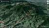 | 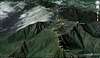 |  |  |  |
Weather Forecast
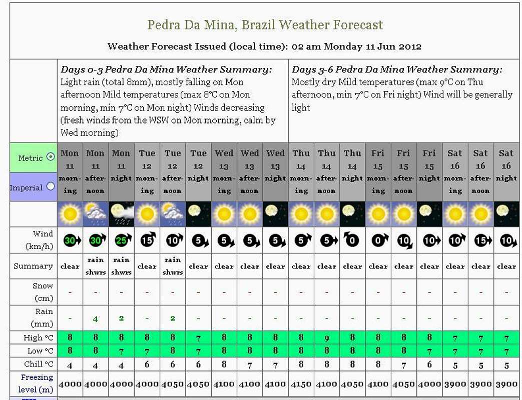
PS: The weather forecast on this link is not for this mountain but it will do just fine since the mountain from the forcast (Mina Rock) is close enough. The same mountain range.
Essential Gear
>Good tent, high on Pedra da Mina (Mina Rock) the winds are strong, sometimes 50 miles/h.>Good down jacket
>Second skin
>Dry waterproof trousers
>gloves
>cap
>sunglasses
>Poles
>Sunblock cream
>food for at least 4 days
>snacks
>4 to 6 liters of water camelback (2 of 3 liters each)
>Might be good a GPS since there is a lot of false trails on the way.
Legal Issues
To hike/ climb is a dangerous activity and requires proper equipment and clothing, the owner of this page cannot be blamed by injuries caused to anyone who read this page for its info about the mountain, and eventually got hurt by doing so with reckless behaviour or bad weather conditions.
Paulo Roberto Felipe Schmidt – AKA: PAROFES
External Links
A brazilian website to get mountains info, including gps files to download:http://www.rumos.net.br/rumos/My youtube channel: www.youtube.com/parofes - Now with 260+ videos online!
The biggest brazilian website about climbing and mountaineering, for which I'm a columnist: