
-
 1583 Hits
-
 75.81% Score
-
 6 Votes
|
|
Route |
|---|---|
|
|
Ice Climbing |
|
|
Fall, Winter |
|
|
Half a day |
|
|
2 |
|
|
Overview
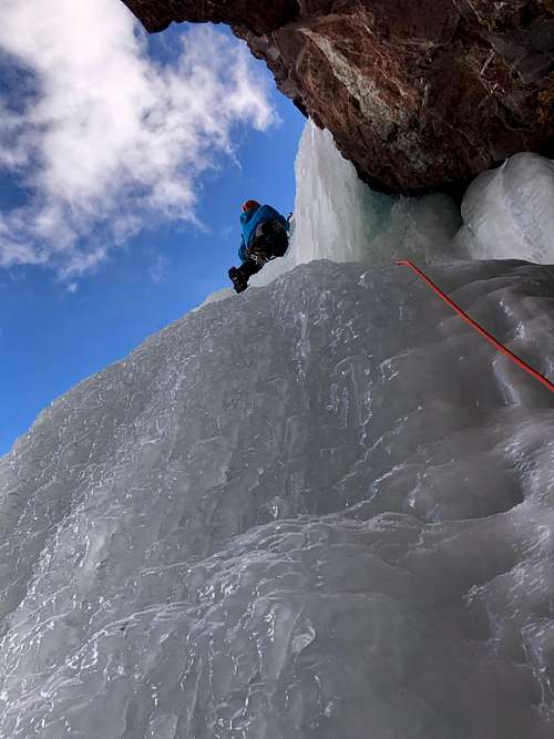 Snotty Nosed Brat WI3/4
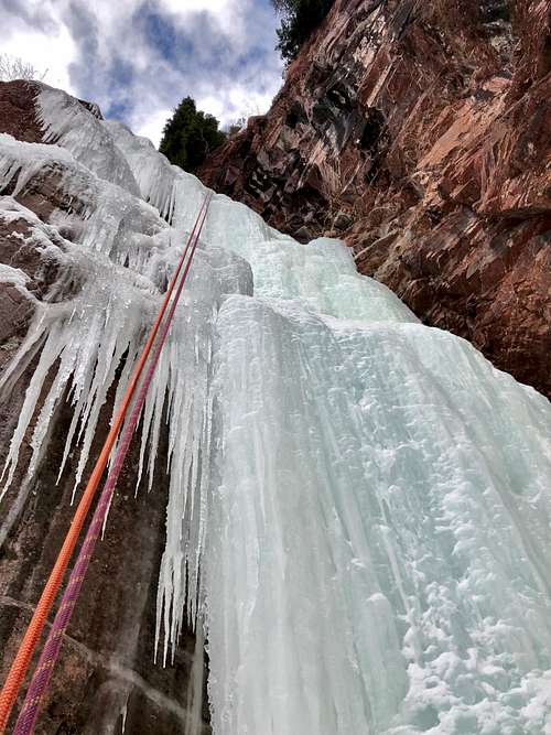 Rappel from Snotty Nosed Brat
It can be a good choice of climb if Direct North Face has many parties on it. The parking is the same for both climbs.
The climb is steeper early in the season with the 2nd pitch flow up to WI5, and later in the season it is easier.
Silverton is a popular ice climbing destination. Most people head towards Eureka with a high density of multi pitch ice routes. South Mineral would be the 2nd most popular ice destination, and typically popular early in the season when one can drive in.
Ouray ice park is located 23 miles north from Silverton along Million Dollar Hwy. The road from Silverton to Ouray goes over Red Mountain Pass, 11,018 feet high pass (3,358 m), with very exposed road, amazing scenery, and prone to avalanches. The road does get closed if there is a lot of new snow fall for avalanche control. Red Mountain Pass is a popular back country ski destination.
Remember the area if prone to high avalanche danger for much of the winter. Always check on conditions before your adventure.
Getting There
 4 WD road to South Mineral Campground
 Mineral Creek
In the winter, it is another story. The road is not snowplowed, and I heard many stories about people camping at South Mineral Campground who got stuck there during a snowstorm. Bring chains for your vehicle and a shovel just in case. Do not drive in if there is a lot of fresh snow and if you don't see any other tracks. Do not follow snowmobile tracks with your car. Also many people use this dirt road for cross country skiing.
It is 4.5 miles from Highway 550 to the South Mineral Campground. Snotty Nosed Brat is about 3.5 miles in. Park at the pull out near where another dirt road branches for Clear Lake.
Route Description
Approach: use the trail for DNF = Direct North Face climb and about 1/2 up turn off. We had no trail here and had to be bushwhacking in a deep snow to gain the climb. You see the climb initially from your approach, but higher up you will not see the ice. Just head for the creek bed/chimney with reddish cliffs.
Pitch 1: Easy flow, could be some snow on it. It is about 50 meters long and difficulty WI 2-3. There was no fixed anchors here (at least we did not find any).
Pitch 2: Steeper section of flow, we found it pretty steep WI4-5 for a short section and then it eased up. There was a tree anchor (small tree with webbings from 3 roots). To reach the anchor required some climbing on moss covered with snow - only a couple of steps.
Descent: We were able to rappel from the tree anchor with two 60 meters all the way down. The climb kind of takes a turn and if you rappel directly, it will depose you about 10 meters above the start. We down climbed this WI2 section to our backpacks.
*Since the climb is short, we repeated Pitch 2 twice. Our original plan was Direct North Face, but there were 3 parties on it.
Essential Gear
- Harness, helmet, ice axes, crampons, warm boots.
- Set of ice screws, runners/screamers, extra webbing or slings for V-threads higher up on route (anchors only on first 2 pitches)
- Two 60 meter ropes
- Consider trekking poles for access and crossing the creek early in the season (later snow covering the creek)
- Thermos with hot beverages is always a good idea
External Links
- Snotty Nosed Brat on Mountain Project
- South Mineral Campground US Forest information (there is a lot more camping available along the road prior reaching the South Mineral).
- South Mineral Climbing on Mountain Project