Snow Creek - Mar. 2, 2008
I couldn't get Snow Creek out of my mind last weekend so I decided to head up for a solo dayclimb on Sunday. After having spent most of my time canyoneering over the past 6 months I was ready to get back to some mountaineering. I had done Snow Creek once before with Rick Graham
two years ago. That occaision was also a dayhike and I recall it was an extremely strenuous day which took around 16 hours to summit and descend down to the tram. It's probably more often done as a 2 day climb.
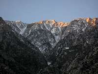
Snow Creek is a southern California classic. With a gain of nearly 10,000 feet in 6 miles (or more impressively 9000 feet in 4 to 5 miles) it is strenuous, committing, and occaisionally perilous. The route ascends the north side of San Jacinto from just beyond the Snow Creek village. This precipitous north face has been described as having one of the largest gains in elevation over such a small horizontal distance in the contiguous United States. For experienced persons only the difficulty of the route depends in large part upon the conditions present -- and those conditions can vary significantly. There are a number of noteable trip reports that are worth reading before attempting the route. One in particular is titled "
Cheating Death on Snow Creek" by J.K. Vawter.
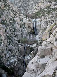
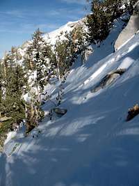
March seems to be the popular month for this route. During this time there is typically continuous snow from about 5500 feet to the summit. Near this 5500 foot level is also a crux of the route -- a very large canyon blocking chockstone with a waterfall over one side. After passing the chockstone it is a sustained snow climb of up to 35-45 degrees depending upon which chute you use to top out.
Approach to the Chockstone
The last time I did this route was in May of 2006 with Rick Graham. That might be considered a bit late for this route but it simply depends on what you're looking for. As the snow begins to melt out a lot of fine scrambling is revealed. I would have no hesitation in doing this route in May again or any other time of year. The scrambling actually makes the route more interesting and strenuous. In March these obstacles are concealed under deep snow.
This time I decided to get an earlier start. I wasn't sure what was in store for me so I figured I'd give myself a little extra time just in case. I arrived near the Snow Creek village Saturday night and found a place to car camp. It was windy -- and not just a little windy! The wind sand blasted and rocked my vehicle all night and I was worried whether the long drive from Bakersfield had been in vain. I just hoped it would die down by the time I got up. Fortunately it did.
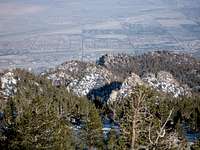
I was on my way just after 4am. Still unsure as to the parking situation I parked down the road from the village next to the electrical shack. It took about an hour to hike up the road and through the desert to the base of the low ridge which separates Snow Creek and Falls Creek. Just minutes up the ridge I lucked out and hit a nice use trail which we had not seen last time. Further up the ridge I stopped and photographed some of the waterfalls in Falls Creek. I've spent a great deal of time canyoneering over the past 6 months and Falls Creek is high on my to do list. Among these falls (one that I could not see) is a 400 foot monster (perhaps the tallest waterfall in southern California). Strangely it is largely unknown and ignored.
At 7:00am I reached the constricted isthmus of the ridge at around 4200 feet. Here the route finding becomes a bit more difficult as it is necessary to pass through a thick brushy section in order to ascend past waterfall problems in the canyon below. Apparently all the time spent bushwhacking down canyons in the San Gabriels has paid off. I had no issues with the brush at all and was able to follow a mostly ducked route up to the small saddle around 5100 feet. Just over the saddle I dropped into Snow Creek canyon and made my way up to the chockstone.
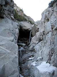
Here I stopped for a break and pondered what lay ahead. Last time Rick and I wasted time attempting to climb the class 5 option to the right of the chockstone only to realize our short rope was not long enough. We had to abort and ended up climbing an easier class 4 section instead. This time I brought no rope. I brought only a cordalette and a couple nuts for emergency purposes. I picked an even easier way up this time and found it fairly trivial.
Above the Chockstone
By 9am I was sitting above the chockstone and gearing up for the final sustained portion of the climb. From the beginning my biggest concern of the day was avalanche potentional. This season has not been particularly friendly with several noteable avalanche deaths in the San Gabriels and Sequoia. It came as no surprise then to see that a sizeable avalanche had piled up above the chockstone. This I completely expected and I was relieved to see. It was obviously at least a few weeks old and meant that a significant hazard (at least to a point) had been removed.
With crampons on I began the relentless snow climb to the top. My avalanche fears were soon put completely to rest when I saw how hard the snow was. From the first step I was on frozen hard snow which remained consistent for the next 4000 feet. It was far too hard to kick steps into but it provided just the right surface for solid crampon footing. It was rather hard on the muscles however. I alternated between front pointing, French stepping, and a combination of both to avoid burning out any one particular muscle group. The only issue with the snow surface was that a slip would be very bad. Because it was so hard a self arrest wasn't likely. Everything was going well however and I just had to be careful.
At 7400 feet I reached the first major fork that joins two large chutes from above. Here it is necessary to take the right fork. It was at this point that I began to notice small bits of pine trees and ice that bounced down from above. Fortunately nothing scary came flying down but I picked up the pace a bit knowing it could only get worse as the sun warmed things up.
At around 8300 feet I came to the second major fork. Here you can go either way. The left is easier but you top out some distance from the summit. The right leads more directly to the summit and is a bit steeper. Last time we went left. This time with things going so well I decided to take the more direct option.
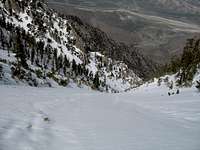
1700 Feet to go
Further up, at 9100 feet and another fork I went left which kept me on the direct approach. Looking up it seemed like it wasn't far to the summit. This was only an illusion however. There was still over 1700 feet to go. Almost immediately I noticed a change. The hard snow now became icy hard and I had to rely solely on front points and the pick of my axe. Thankfully I had sharpened the front points of my dull crampons the day before. That proved to be a wise decision.
With my front two points only penetrating about an inch I took each step carefully. I really wished I had an ice tool in addition to my axe now (two tools would be even better). The slope angle also became steeper (about 40 degrees). With my crampons biting well I still felt fairly secure. After a few hundred feet I was fully committed. A downclimb now would be extremely difficult. Occasionally I'd hit a softer spot where my crampon would punch through an outer styrofoam crust but for the most part the snow remained icy hard.
It wasn't long before my calves started to burn from the continuous frontpointing. There was no option for a break. Eventually a muscle in my left leg from the knee to my inner thigh began to cramp up painfully. I kept trying to shake it out but there wasn't much I could do. I decided to see if I could find anything I could kick steps into so I pushed out to the left side of the chute up toward some bushes. Here there were softer spots but the footing wasn't very reliable so I moved back onto the ice again.
No Retreat
At 9600 feet was yet another fork. The right chute appeared to be the direct route but it looked steeper and shiny toward the top. I was close to the limit of my gear so I decided to go left. Just below 10,000 feet I took a final fork this time to the right. Soon I encountered something that got me a little spooked. I started punching through crust again. The problem was that below the crust was about 6 inches of granular powder which in turn was on top of a layer of boilerplate ice. The crust would fracture and crumble away along with the granular stuff underneath. I couldn't establish a reliable footing or axe belay and was concerned that if a large enough sheet of the crust broke loose I could very well ride it down. Thus, I decided to climb out onto the ridge left of the chute. Here there were some rocks and trees which I thought might give me more to work with.
This put me into steeper terrain (perhaps 50 degrees) and lead to more challenges. Around the rocks and trees were air pockets. A lot of the rocks had clear water ice on them. On a positive note when I got close to a tree I could frequently grab onto a branch and help pull myself up. Then just above the tree I could finally rest in relative safety. Getting from one tree or rock to the next however was another matter. Further up where the ridge got more rocky what I thought initially would be an easy class 3 problem looked like it might go class 5. That was still a ways off however.
For awhile I got stuck below a smaller rock where the footing wasn't great. The rock above was covered by a sheet of sloping slick ice. There was no way to pull myself up over the rock so the only option was to go around one side or the other. Both sides had ice and the unstable crusty layer. I attempted to make moves on both sides but the crust just crumbled away. The ice on the rock above was too hard to get the pick into. For the first time I thought I might have reached an impasse and retreat was not an option.
Fortunately I still had plenty of time. After about 30 minutes stuck below the rock I was able to clear out most of the unstable crust and granular stuff off one side. This left hard ice that I couldn't get the crampons into but I was able to chop some steps. I even carved out a small hold in the ice above me that I could sink my fingers into. Eventually I felt I had enough to work with and pushed through the move. Above the obstacle I quickly made my way up to the next tree. I was now getting cold and it was getty windy.
Above me lay the next hurdle. The rock outcropping above that I hoped would be class 3 was indeed class 5 and there was a significant problem with clear ice here as well. Staying focused on the task at hand I examined all my options. Directly above me was an angled slab that I thought I might be able to ascend directly using an exposed class 4/5 lieback for about 15 feet. Trouble was I would have to do it with crampons on because there was no safe way to take them off. I started the move a couple of times but deemed it too risky. I finally settled on some moves around the right side of the outcrop. I couldn't see all the way around however and just took the risk that what I couldn't see would work. It did! After about 20 feet of class 3/4 climbing on rock with crampons on I arrived at the crux. Directly above me were two tilted slabs supporting each other. The move would be a hands only pull up with no footholds (5.8 perhaps). I had no idea what was above that.
Unfazed I looked for other options. Underneath the slabs I was rather safe in the confined shelter they made. In the very back I noticed a small crawl space. Could I get through there? It was very tight but I cleared away enough snow that I thought I might be able to just barely squeeze through. I took my pack off and shoved it up through the hole. It was a tight squeeze but after struggling for several minutes I made it. This put me into another sort of chamber above. I had a good feeling. When I climbed back out into the light I saw that I was above the crux. Above me were a few more class 3 moves but above that the ridge mellowed out and I could see no more obstacles. I had done it.
It was now just after 3pm and I was stoked. To my surprise the summit was still further away than I thought but at 3:49pm I finally reached the top. It was very cold and windy. I was alone on the summit. I stopped just long enough to take some photos. I didn't bother looking for the register box even if it was accessible. The notepads are usually just a wadded mess anyway. After leaving one hand exposed to windchill too long I started down.
Descent
Descending to the tram the snow was the same firm hard stuff I had most of the way up. Perfect for crampons and with the excellent coverage I took the most direct path down to the tram possible. It took only an hour and 20 minutes to reach the cement walkway. Here families were playing on the hard slippery snow. Sleds proved to be uncontrollable rocket ships of death on the hard surface. After gearing down I ascended the walkway to the tram station finishing the journey at 5:26pm. Despite the challenges it had only taken 13 hrs 19 mins. This was considerably better than the 16 hours it took the time before.
I celebrated (the fact that I was still alive) at the bar upstairs. The quesadillas weren't bad and the cold beer hit the spot. I talked to one of the bartenders (Ginger). This was her 2nd day on the job though she had worked here back in the 70's (when they had the old tram cars). She wasn't yet used to the elevation. I even managed to get a free refill!
Now partially satiated (I only had a small snack the entire day) I took the tram down and took a taxi back to Snow Creek. I had a fun time talking with the cab driver and despite it costing nearly $50 (including tip) it hardly mattered. I actually considered walking the 11 miles back to my car but since I had already used non-human power (the tram) I figured it was hardly worth the effort. For once I would take the easy option.
Photos
Snow Creek - Mar. 2, 2008


Comments
Post a Comment