South Sister (10,358 ft) Date: June 27, 2003
Report: Dean Molen
So. Sister is not only the third highest peak in Oregon, it counts for two counties (a twofer) and that makes it very special to me. Since my goal is to get all of Oregon done, a twofer is sweet.
Bob Bolton and I had gotten weathered off of an attempt the previous week so I had my eye on the forecast with the hopes of getting back down to central Oregon and getting this one taken care of. Since Bob had been sick all week, I decided that I would go solo and go for this since otherwise I wouldn't get it done. Not a technical mountain, but wise to carry an ice axe and perhkaps crampons at this time of year due to the amount of snow still remaining.
![So. Sister in the early...]()
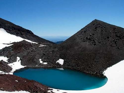
I had caught an afternoon weather report on Thursday that was very rosy indeed and so at 5 p.m. I packed up my gear and headed south to Bend. Arriving at the Devils Lake TH at 10 pm, I snatched a few hours of sleep in the back seat of my cozy Honda Accord. Dawn brought clear skies and I was heading up the trail full of enthusiasm. At the 6200 foot mark, I encountered snow and my pace slowed as I did not want to get burned out early on. I made a GPS waypoint at where the trail left the woods and that came in handy later in the day. Foot prints led the way as I followed in the wake of several others who had beat me up the trail and thusly I made my way up the mountain. At around 9000 feet, I got onto a ridge just above a small lake that sits at the foot of the Lewis Glacier. The only negative with the ridge was the make up of it, loose volcanic materials that often made you take two steps to gain one. Nothing on this mountain is solid, it all moves under your feet so you have to watch your footing. The angle steepens as you near the crater rim and there was only one place where I felt an ice axe would have been a good choice. BTW, I did have my ice axe and crampons but could have done without the extra weight.
![Small melt lake at base of...]()
When I broached the top of the crater rim, I still had some work to do. I could see the highpoint a quarter mile away on the north side and it kind of reminded me of when I climbed Mt. Rainier, you get to the crater rim but still have a fair amount of work left to get to the highest point. I chose to trudge directly across the crater although I did encounter a small crevasse on the far side. I easily stepped over it and proceeded to climb up to what was obviously the highest point. I dropped my pack and grabbed something to eat and drink. While the wind was blowing pretty good, the view was staggering. I pulled out the camera again and snapped off some pics. I was disappointed when I got home to find out that several of the shots I thought I had weren’t there. I was using gloves when I took the pics and evidently missed the right shutter pressure connection. Ah well, it was one of those perfect days when there is no haze and you can see forever. Wow. I had almost forgotten to take my GPS readings and so I proceeded to accomplish that but now realize that I didn’t allow the elevation to get ‘caught’ up. I photograph my GPS summit positions to compare at home with Topozone but the photo showed a difference in altitude. I then remembered that I probably didn’t give the unit enough time to allow the elevation aspect to get up to the right height. It was photographed at 10238, 20 feet low but I had made very sure there was nothing higher around so mission fulfilled, South Sister was mine. Oh oh, now I had to go down. Bummer.
It was a real trudge getting back down and very tiring. The volcanic rock junk would slide at every footstep and you had to watch every single step. Occasionally I could get an exciting although unintentional boot glissade going on the volcanic duff but mostly I carefully made my way down. Now was no time to turn or break an ankle. I thought the snow would be easier but thanks to the intense sun and rising temperature, the snow was soft and you’d sink with every other step. Glissading wasn’t worth the effort as you wouldn’t slide very far on the very wet snow. Skis, they would have been nice. Anyway, it was a great day and I can stick a fork in two more Oregon counties cause they are done.
I only encountered 5 people coming down as I was going up and about ten people coming up as I was going down. Perfect weather on a high Oregon peak is a real joy. This is one I'd do again.
Comments
No comments posted yet.