
-
 4194 Hits
-
 81.18% Score
-
 13 Votes
|
|
Route |
|---|---|
|
|
48.81330°N / 113.6562°W |
|
|
Scrambling |
|
|
Spring, Summer, Fall |
|
|
Class 2-4 depending on exact route |
|
|
Overview
Really, this route should be called the "South Slopes" or perhaps the "South Face" route since it climbs straight up the south side of Altyn Peak almost directly to the summit cairn, but it gets its name for a large snowbank that lasts into early summer and resembles South America in shape.
Of all the established routes to the summit, this one is the shortest and the steepest. Climbing difficulties do not have to exceed Class 3, and the route is mostly a really steep hike. If you have strong legs, if you like to suffer, or if you just like to get down to business, this is a good route for you.
Despite the fact that the route is named for a prominent snowbank, this is not a snow route. The south-facing slopes of Altyn Peak are extremely steep and sun-exposed and thus melt out very early for Glacier National Park. When climbing the route on July 11 of what had been a near-record snow year, the only notable snowbanks on the south side of the peak were South America and a smaller patch higher up and not along the route. In August of most years, there will likely be no snow at all.
My source of information for this route was A Climber's Guide to Glacier National Park, written by the late and much-revered J. Gordon Edwards, the "patron saint of climbing in Glacier National Park." This guidebook is a fantastic resource for information about climbing in the park, but as many have discovered, the route descriptions can sometimes be erroneous or at least lacking, creating the potential for climbers to get themselves into trouble. Climbing the short South America route, I used a variation that was more direct and enjoyable than the guidebook route and also discovered a problem with the route description, a problem not likely to get climbers into trouble on the way up but which might cause trouble for climbers using it as a descent route after having come up another way. Both the variation and the problem will be covered in this page's route description.
Note: The south slopes of Altyn Peak and its higher western neighbor, Mount Henkel, are prime spots for bear activity. In fact, a favorite pastime at the Many Glacier Hotel is standing on a balcony and watching bears on the mountainsides; watchers are almost guaranteed daily sightings, especially early in the morning and late in the afternoon. Both black and grizzly bears are commonly seen out here, and both can be dangerous. Be alert, be prepared, and take precautions. This means making noise, especially where visibility is limited (most of the south side of Altyn Peak is open and presents no visibility issues, but there are two brushy areas lower on the South America route that are places of concern), carrying pepper spray (and having it accessible and knowing how to use it), and being wise enough to yield ground to the bears when encounters do occur (i.e. don't stupidly pursue them for that perfect picture).
Another Note: If the South America snowbank is present, there will be running water in the drainage below it. This will be the only source of water along the entire route unless there are some scattered smaller snowbanks (not likely), so plan accordingly.
Getting There
From Babb, turn off U.S. 89 and head west on the road signed for the Many Glacier area of Glacier National Park. When you reach the park entrance station, note that unless you already have a pass, you will have to pay a $25 entrance fee (2011), good for a week.The start of the climb is unmarked but very easy to find. Directly across the main road from the road to Many Glacier Hotel, notice a trail climbing steeply to the north. A picture here shows the start of the trail. On both sides of the road near the trail, there is room to park while remaining on pavement but without blocking the road.

Route Description
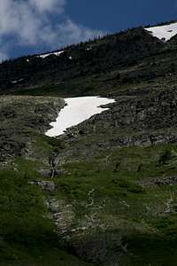
 The route as seen from the road
The route to the summit is only 1.5 mi, actually a little shorter (1.2-1.3 mi) if you take my more direct variation, but the elevation gain is a staggering 3050', so you will get a workout.
Follow the steep climber's trail up the mountainside. Keep in mind that this lower section is where you are most likely to surprise a bear or have a bear surprise you because of trees and brush that obscure visibility.
Your first destination is the South America snowbank; if it has melted out, it should still be clear that one has to ascend along the obvious drainage, and hopefully pictures on this page will have been illustrative as well. The climber's trail fades out before you reach South America, but the terrain is easy to negotiate; there is little brush, and there are no major route obstacles.
Climbing or glissading the snowbank is not necessary and does not appear to be a great idea, either. In one spot, it is almost vertical where it covers what must be a cascade, so a fall or uncontrolled glissade anywhere it could prove disastrous.

Ascend along the right side of South America. In places beside it and above it, there are some small cliff bands that are easily scrambled or bypassed.
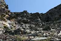
Above the snowbank and the small cliff bands, the mountain is a massive scree slope until you reach the summit cliffs that are still more than a thousand vertical feet above. Head for the base of those cliffs and, as Edwards says, angle slightly eastward as you do so. Photos here do illustrate where to aim.
 |
 |
Here is the part of the route description that could be problematic. The Edwards guide says to get to the base of the cliffs and then ascend along a wide scree-covered ledge that passes almost directly under the summit and deposits you up on top not far east of the summit.
Now, it is possible that I angled east more than Edwards did, but my course did seem like the most logical one. The problem is that at the base of the cliffs, there is a very wide, very obvious scree-covered ledge extending upward and eastward, and it looks like the sensible choice. However, it is not, for that ledge leads around to the eastern side of the mountain, where there are "unclimbable" cliffs blocking access to the summit. I verified this on my descent, for I wanted to use the ramp as an easier alternative to my ascent course. See here for a look at what you're getting into if you try heading around to the eastern and northern sides of the mountain this way.
Already tired of hiking up scree, I instead decided to climb the cliffs. There was more than one way up them; the way I took was mostly Class 3, a little Class 2, and a bit of Class 4. I wound up on top about a thirty-second walk from the summit.
 |
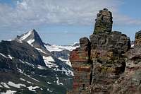 A great view during the cliff climb A great view during the cliff climb |
On the way up, I did spot what is probably the diagonal ledge that Edwards refers to. Reaching it requires some easy scrambling from the base of the cliffs, and it does lead to the top a short distance east of the summit, though not as close as my route got me. From the summit, I found the upper end of this ramp and used it to descend back to the extensive red scree slopes on the mountain.
 The diagonal ledge The diagonal ledge |
 |
Bottom line: there are intuitive ways up this mountain. Don't rely too heavily on the guidebook. If in doubt about the ramps, and if you like scrambling, then take on the cliffs in the section shown on this page.