
|
|
Route |
|---|---|
|
|
39.67980°N / 106.2581°W |
|
|
Scramble |
|
|
Most of a day |
|
|
Class 2/3 |
|
|
Approach
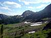
From the Bighorn Creek Trailhead (see "getting there" section for driving directions) hike up the Bighorn Creek Trail for approximately three miles to the small cabin in the meadow. The official trail ends here, but a well-worn climbers trail continues up the valley. Follow this until it breaks out of the trees into a very large meadow.
 |  |
Route Description
When you reach the meadow angle up to your left. You can either attain the ridge from the east or contour around the ridge to the south into the cirque on the west side of the ridge. Contouring around the ridge to the west will give you a more gentle ascent and gives you an excuse to visit the beautiful cirque to the west of the ridge.
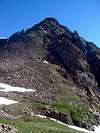
Either way, once you get onto the ridge you will be presented with two steep, grass gullies. Take the one on your right (east) as the one on the left gets very steep at the top with loose rock. After topping out of the gully you'll crest a rise and then descend slightly to a saddle. From the saddle you'll see a false summit and the climbing up to this false summit is primarily steep grass with a little boulder hopping.
After you achieve the false summit the slope of the ridge lessens a little and you leave the grass slopes behind. If you try to stay on the ridge proper you will scramble across fun class three terrain with an occasional class four move. If you'd like to keep things easier drop down a little bit on the west side of the ridge to stay in class two terrain. Basically you can make this part of the climb as difficult as you want.
This scrambling continues to the crux of the days climbing - a daunting notch. At first glance the notch might seem impassible, however there is a small gully that you can use to descend down the east side of the ridge about fifteen feet. From there you can carefully scramble above the snow slope to the top of the notch. A couple of these moves are awkward and the rock is loose in places so take care.
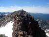
Once across the notch it’s easy class-two scrambling up to the summit of Skiers Point.
From Skiers Point, Climbers Point is much closer than it appears and it’s mostly tundra slopes mixed with a few boulders between you and its summit. The hike from Skiers Point to Climbers won’t take much more than fifteen to twenty minutes.
Return the way you came.
 |  |
Essential Gear
No special gear is need during the summer months. An ice axe might come in handy in the spring and might also give you other options to ascend Skiers Point such as snow couloirs from either the Bighorn Creek side or from the cirque to the southwest.
Miscellaneous Info
If you have information about this route that doesn't pertain to any of the other sections, please add it here.