
|
|
Route |
|---|---|
|
|
28.0188°S / 68.756°W |
|
|
A few days |
|
|
high altitude |
|
|
Approach
 Bonete from SW
From the road to the mountain take the furthest left valley (seen from Laguna Brava) on the SW side.
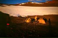
 with 4WD at the starting point (4900m)
Route Description
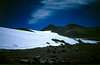
 penitientes at 5100m
Since 4WDs can drive up very high and the route doesn't involve any difficult section it can be recommended as an ascent route for Bonete. Snow is available few hours above the starting point at nearly every site.

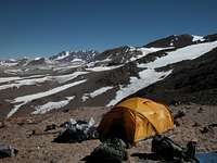
From the starting point follow the dry arroyo for the next hours. You will now pass the first snow and penitientes fields. Cross the first larger snow field and walk up the following slope. On a plateau infront of the next large snow field you can pitch your tent for camp 1 at 5700m. If there is not much time for further climbing don't go higher, because the there is no good camp site for the next two hours .5-7 hours
 Camp 1
From camp 1 follow the the cascade of the snow fields. There are several route options, but you can do nothing wrong. 1.5 hours above camp 1 the Caldera del Inca is visible. A last steep passage brings you to the plateau from where you can see the summit for the first time.

From camp 2 it's two hours to the col to the north side. At the col the luggage can be deposited. From the col walk toward the the saddle between the southern pre-summit and the summit. From the saddle a rough sree slope brings you to the summit. 3-4 hours
After descending back to the depot the route goes nearly direct north. Avoid descending to early and traverse as far as possible north. Than descend in the lose and sandy scree of the NW flank. At 5500m is a possible place for camp 3 close to a penitientes field. It's an additional hour down to the valley, where one can find snow and running water (5300m). 3-4 hours
From camp 3 one can either follow the valley to the west in direction of Mieszkos Torn from where 4x4 transport should be possible or one can go north through the Gran Crater for Pissis in additional 2-3 days.
All times are approximations for climbers with heavy backpacks (~30kg). With light weight packs the summit can be climbed from camp 1 in one longer day.
 Caldera del Inca
GPS coordinates
 view from Camp 3 towards Monte Pissis