
-
 8934 Hits
-
 73.06% Score
-
 3 Votes
|
|
Route |
|---|---|
|
|
48.97510°N / 121.7086°W |
|
|
Basic Snow, Scramble |
|
|
Most of a day |
|
|
Class 3 |
|
|
Approach
See Getting There. Hike to the tarns beneath Yellow Aster Butte.
 |
Route Description
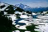
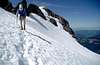
From the upper pond area hike toward the long broad ridge trending NNW, which culminates at Tomyhoi Peak in approximately another 2.5 miles. Ascend to the ridge top and hike the ridge in meadows and grand views until you reach the rock. Cross a hump, then descend about 200 feet to a rounded col at 6,300 feet. Continue upward as the ridge broadens again. Upon reaching a narrowing rocky section, traverse around the north flank of the ridge on an expansive bench system, avoiding several rock pinnacles by traversing the top edge of the glacier on snow or firn. Climb over a rocky hump (the false summit), descend 100 feet to a notch at 7,250 feet, then climb moderately steep but firm rock along the left edge of the ridge. Cross a narrow 50-foot level gable. Follow a ledge west for 30 feet to a broad corner, turn right and take easy scree-rock ledges west of the crest to the summit.
 |  |  |  |  |
Essential Gear
An ice axe is mandatory. Crampons may be desirable on occasion. A hard hat may be desired on the summit block.
Miscellaneous Info
If you have information about this route that doesn't pertain to any of the other sections, please add it here.