
-
 17779 Hits
-
 89.01% Score
-
 28 Votes
|
|
Route |
|---|---|
|
|
48.51388°N / 113.60413°W |
|
|
Mountaineering |
|
|
Summer |
|
|
A few days |
|
|
Class 3 |
|
|
Overview
This is in my opinion the least technical route up Mount Stimson. If you are looking to avoid large lengths of off trail bushwhacking and class 4 cliffs this is one way to go. Its a great route if you are looking for a non technical scramble in some extremely remote country. Not to mention Mount Stimson is a truly monstrous mountain, even by Glacier's standards. The worst you will find is a lot of class three cliff bands and a relatively exposed traverse of Mount Pinchot's west shoulder during the approach. My brother and I climbed this route in mid july of 2007. There was very little snow pack the year we climbed it so our route was free of snow, however this may not be the case in a typical year. On the other hand most of the route is on the southern face which does get a lot of sunlight, I would imagine the route would be snow free by the beginning of August most years. The first ascent of this route was by Joseph Biby, Doug Mason and Greg Nelson on July 30, 1978.
Approach
There are a few ways to get to the lakes: either 16 Miles up Coal Creek, 23 miles up the Nyack Valley or 21 miles up and over the continental divide at Cutbank pass from Two Medicine. You can cut off about 2 miles of this route if you take the ferry across Two Medicine Lake.
The trails in this area are minimally maintained (I counted 148 downed trees on the way in) and the section coming down from Cutbank Pass is the steepest and most brush infested section of trail I've ever run into. (Saintgrizzly spoke with some of the park rangers about all the downed trees. They were from a monster storm in November of 2006 and they are working on clearing them. As of July 2007 though they were still down.)
I would still recommend coming in from Two Medicine however; you don't want to spend your entire approach in the trees! The 5 miles between Dawson and Cutbank Pass is worth the trip alone as the trail is perched 1000s of feet above the Nyack Valley and the views are incredible. Either way you go its almost impossible to get to this point with out a night spent somewhere on the way in. The bowl north of Mount Tinkham has plenty of water and is about half way in from the Two Medicine area.
Once you get to the lakes most people spend another two nights here, one before the climb and one after as the climb will likely take 12 plus hours. The first step is to get to the shoulder that connects Mount Pinchot to Eaglehead Mountain.
If starting from Beaver Woman Lake wade through the thick brush on the left shore of Beaver Woman Lake (make plenty of noise as bears frequent this area) aiming slightly to the left of the large rock buttress (pictured to the left) that comes off of Mount Pinchot. Once you get through the brush hike around the low cliff bands to the left of the buttress and you will see a large green notch filled with large boulders that leads up to the shoulder. This area is wide enough that you can pretty much pick any route you want to get to the shoulder.
The broad scree covered southwest shoulder of Mount Pinchot now spreads out before you. The key is to maintain roughly the same elevation as the saddle during this traverse, because once you get around the corner to the northwest face there is only one elevation that traverse can be made.


I've been told that there are alternate ways to get to this saddle. One involves starting on the park's western border and bushwhacking up Pinchot Creek. I've never done it and it looks like a lot of work, but it is definately a more direct route (8-9 miles instead of 20 plus). Anyone who has spent time in Glacier's brush knows the value of a trail however.
Route Description
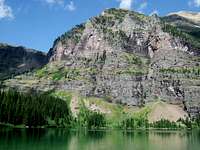
 Overview of the route. The larger view is a little more helpful.
 Once you get to the saddle the route actually begins. This is a good place to get water as there is usually snow melt coming off the south face. The summit is still 2,500 feet above you at this point. Once you get across the saddle you will see a dry stream bed that angles across the south face to the southeastern spur. This stream bed is a little less tiring that hiking up the scree. The dry bed leads you to a series of tall cliffs that guard the upper slopes. Once you reach the base of these cliffs traverse to your right towards the ridge line until you see an opening in the cliffs.
Climb through the cliffs (class 3 if you take the right route). You are now on the broad southeast spur. From here you want to stick relatively close to the eastern edge of the southeast spur and aim towards the far eastern end of the flat summit ridge. There are a multitude of routes that can be taken through these broken class 3 cliff bands, just make sure you end up at the eastern end of the summit ridge. The cliffs aren't bad but as you go upwards they get steeper and pile on top of one another, so towards the top it starts to feel a bit hairy. If you have climbed in Glacier before these slopes will feel pretty familiar.


The upper 150 feet of the south face and southeast spur cliffs out into a tall cliff band, but if you stick to the far eastern edge of the spur the band breaks up to the point where its easy to climb through them and gain access to the flat summit ridge.

The tallest point on the summit ridge is actually on the far western end. Although the ridge looks narrow its pretty easy to traverse your way over to the western end. Drop off to the sides when you need to.
A few minutes later you are standing on top of the mighty Mount Stimson! Check out the views from the top on the main Stimson page (if you don't mind spoilers) or even better skip the pictures and get up there yourself!
Essential Gear
I would bring:Wind Pants
Fleece
Wind Breaker
Stocking hat (just in case)
Food for lunch and snacks as you'll be climbing most of the day
Emergency survival gear (lighter, matches, emergency blanket, compass, whatever else you need to feel comfortable in case stuff gets ugly)
Some flagging for marking the route (just make sure to pick it up on your way down)
Camera!
Fred Spicker - Oct 22, 2007 8:17 am - Voted 10/10
Name / First AscentIf you wanted to be consistent with the name of the route as given by Edwards in A Climbers Guide to Glacier National Park - this would be the Southeast Spur Route. First ascent Joseph Biby, Doug Mason and Greg Nelson on July 30, 1978.
whiteroom17 - Oct 22, 2007 11:11 am - Hasn't voted
thanksthanks for the corrections, i've added them to both the route and mountain pages. I'll go through tonight and do a bit more cross referencing with the climber's guide
EricHansen - Oct 26, 2007 9:47 pm - Hasn't voted
additionsI added a Pinchot Cr. comment (I've done it and it is good) under comments. Eric Hansen
whiteroom17 - Oct 27, 2007 12:14 pm - Hasn't voted
thanksthanks for the addition i will add the information in sometime this weekend.
louhibbard - Aug 24, 2019 1:01 pm - Hasn't voted
Start of 3rd class traverse GPS coordinatesI never did find the start of the traverse across Mount Pinchot's SW and western face on the way up. There were no cairns whatsoever. I forced a way across on a ledge system it turns out higher up - some easy 5th class. I then joined the "trail" about 2/3 of the way across. On the way back I did find the trail - there was the occasional cairn but the last 1/2 mile had no cairns (the start coming up). It is apparently against park policy to have cairns like that and park personnel will knock them down. The GPS coordinates for the start of the traverse going up are: N48.49149, W 113.60332, elevation 7687 feet. From this point if you face Stimson the trail angles steeply down and left down a gully/chute before leveling off into the sloped scree dicey 3rd class in places "trail" . There will be cliffs below and above you all the way across this traverse.