
|
|
Route |
|---|---|
|
|
39.75000°N / 106.3367°W |
|
|
Basic Alpine Mountaineering |
|
|
A long day |
|
|
Moderate / Steep Snow, Class 4 Rock |
|
|
Introduction
 | An unnamed couloir on an unnamed peak combine to provide a superb moderate alpine mountaineering route in the heart of Colorado's rugged Gore Range. The beautiful approach hike, interesting routefinding to the base of the climb, 1000 feet of alpine snow, several hundred feet of delicate rock scrambling, and stupendous views make for a memorable outing. Check out Andy's trip report for more details and photos. |
Approach
 | There are two possible approaches to reach the 11'400 foot tarn filled basin at the base of the climb. According to attm, one is to climb from about 1/2 mile before Kneeknocker Pass in a nice grassy area that the stream runs through to a saddle south of Peak C, near Point 12,225. Check out his map, and Kneeknocker Pass route description on this page. The other, which we did, is to climb up from the Piney River below Point 11,825, also known as Jagged Peak. There are excellent campsites along the river herel. To reach these campsites hike for about 3 miles from the trailhead at Piney Lake Lodge. At times the trail can be difficult to follow, and the river has occasionally cut a narrow gorge through the rocks forcing you up and over these sections, unusual for a Colorado approach which is typically just up! The campsites are located at about 10,000' along a half mile section of nearly level ground. |
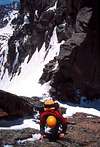
 | Peak C and the route are not visible from these camps, but 1,000 feet up the slope towards the Peak is a large waterfall. This is clearly visible from the river. Surprisingly, neither the waterfall nor its stream appear on the USGS topo map. |
 | The first objective is to reach this wate rfall, sinc e the slopes around it %0 D provide access to the basin above. We used a combination of game trails and rock scrambling through the forest near the stream to reach the falls. We generally kept to the trees to avoid the thick vegetation in the open areas by the river. |
 | Once you are above the water fall you are in a stunning cirque filled with several small tarns. The views here of Peak C and C-Prime, Jagged Peak, and a host of other unnamed summits are spectacular. |
Route Description
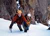 | The couloir climbs for about 1000 feet. Most of it is at an angle of around 40 degrees, then it narrows and steepens to 50 degrees for the final 200 feet. Just below the steep section we encountered an area of shallow snow over loose rock slabs. This was in mid June, presumably later in the season these rocks would be fully exposed. |
 | The couloir tops out at a narrow saddle on the ridge between peak C-Prime on the right (east) and Peak C on the left. The saddle was just big enough for three of us. There is a definite alpine feeling at this spot! Attempting Peak C-Prime from here is not an option without a rope and rock gear. |
 | At the saddle you stow your ice axes and set off onto a section of Class 4 rock face. The rock is of dubious quality, solid looking at first glance, but you quickly discover that it flakes like shale and surprisingly large pieces can be moved with ease. |
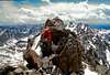 | Above the face a complex ridge stretches out towards the summit. The exposure on the right (north) will catch your attention, and that on the left is not to shabby either. There are several small pinnacles along the ridge that must be passed on one side or the other, or perhaps tackled straight on. I personally would not want to be on this section in a strong wind. |
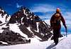
 | For the descent we elected to exit the ridge to the south before we returned to the loose face above the saddle. We found a 3rd class gully that we hoped would dump us back in the couloir below the shallow loose rock section. This in fact worked out perfectly. Once back in the couloir the descent is fast with a combination of plunge steps and glissades. |
Essential Gear
 | Ice axe and helmet are certainly required. Crampons should be carried although the day we were there the snow was soft enough that we didn't use them. A short length of rope and some rock pro would not be out of the question in case conditions turned bad on the ridge. If you are far better than I ever was or will be, you can bring skis for the descent. Short story here. |