

-
 15995 Hits
-
 86.37% Score
-
 22 Votes
|
|
Route |
|---|---|
|
|
45.92828°N / 7.78476°E |
|
|
Mountaineering |
|
|
Summer |
|
|
Half a day |
|
|
Alpine PD+ |
|
|
Overview
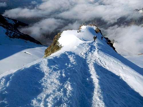
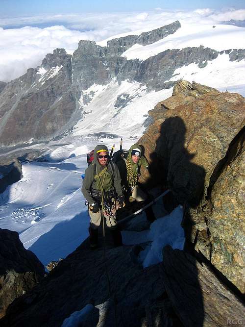
A beautiful finish - looking back to climbers ascending the final snow ridge
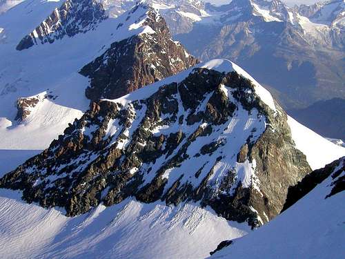
Polluce - Pollux 4091 m is a beautiful pyramid with a dome-shaped top and has three glacial sides and one rocky, the one ascended from the Via Normale from the Guide d’Ayas Refuge, on the south-west side. Pollux and the neighboring Castor are also called Gemelli, Zwillinge.
What is it that defines which way up a mountain is the normal route? Is it the easiest one, assuming that all routes are in good condition? Or does an otherwise easy route that's usually out of shape not qualify? Or is it simply the one that is climbed most often?
Judging by the guidebook ratings, several routes to the summit of Pollux, or Monte Polluce in Italian, are of similar difficulty. The easiest is the snow covered west flank (PD, up to 45° steep), provided it is in good shape: firm snow, no ice and no avalanche risk. Nevertheless, the marginally harder southwest ridge (PD+) is the route that is climbed most often. Perhaps the conditions on the west flank are often not suitable, or perhaps it's just that the average climber prefers a varied mixed route over a straightforward snow plod. Speaking for myself, I certainly do. And last but not least there is the northeast ridge (PD/PD+), which can be climbed on its own right, but is perhaps more popular for those wanting to traverse the mountain.
Anyway, whether it is deemed to be the normal route or not, the southwest ridge is fairly easy. It starts with a fun rock scramble on the ridge for the first 200 m of elevation gain, followed by a very scenic snow ridge to the summit. And all that against the backdrop of the big peaks of the heavily glaciated Monte Rosa massif. It's not all that long a climb, which, when starting from Rifugio Guide della Val d'Ayas or Bivacco Rossi e Volante, leaves enough time to climb Castor as well, a combination that is done regularly.
Getting There
Pollux is a border peak, with Switzerland to the north and Italy on the south. Though the start of the route can be reached from either country, the southwest ridge lies completely in Italy.
From Switzerland
From Switzerland, the majority of climbers use the (rather pricey) Klein Matterhorn cable car from Zermatt to get to 3800 m, which owes its existence to the ski area and to the many tourists from all over the world that want to have a closer view of the big glaciated mountain landscape. On foot, it would be a long day from Zermatt to reach the same cable car summit station, so few people do that. In fact, thanks to the cable car it is possible to climb Pollux and get back down to the valley the same day, which some climbers actually do. However, if you're in the neighborhood, you might as well spend spend several days up there and climb a number of the 4000-ers of the Monte Rosa group. Even on a short trip, it's easy to add Castor and some of the Breithorn summits.
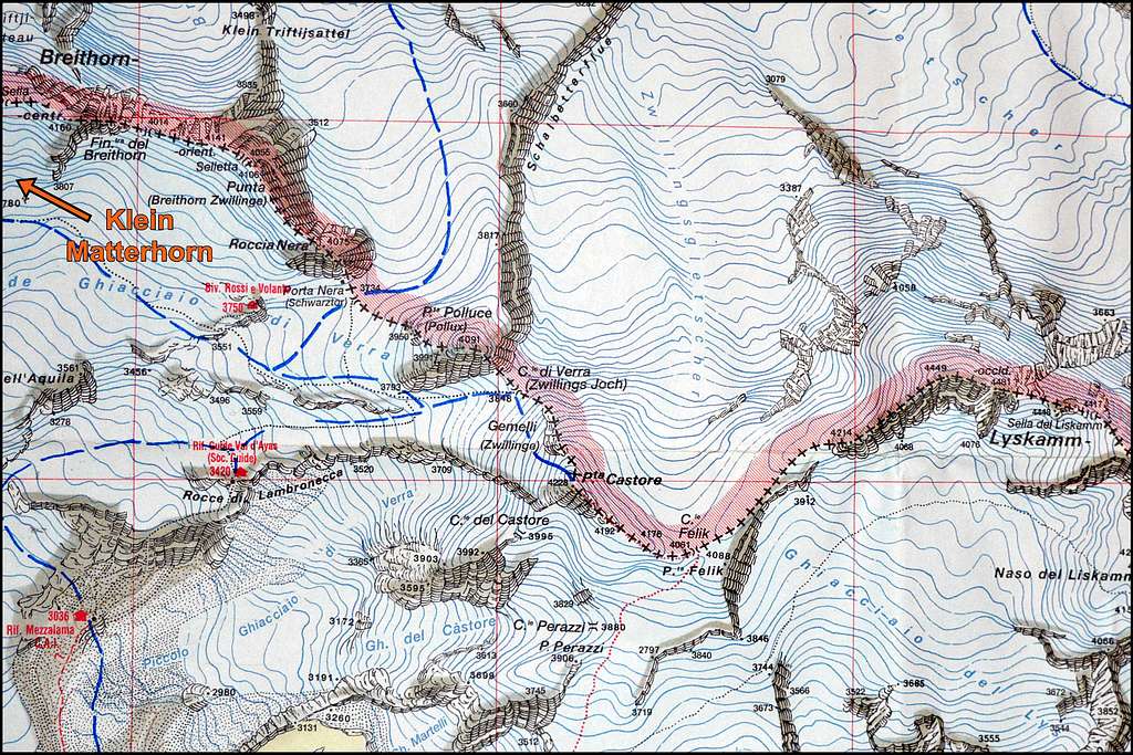
The exit of the cable car summit station is on the south side. Step outside and look to your left, i.e. to the east, and you'll see the big Breithorn massif, with Breithorn West (4164m) as its highest summit. The route to Pollux starts the same way as the one to Breithorn, but traverses its southern slopes. However, immediately east from the cable car the glacier drops down quite a lot and has a dangerous crevasse zone, so don't head directly east. Instead, start out to the SSE, towards the minor summit of Gobba di Rolin (3899m) just over a kilometer away. This is a ski area, even in summer, and this part of the glacier is virtually flat. After only a few hundred meters, well before the terrain to the south starts rising, the terrain on your left gets flat as well, and you can now turn east. This is the Breithorn Plateau. Usually there is a big trail, because Breithorn is one of the most often climbed 4000-ers in The Alps.

How long the route to Pollux follows the big trail to Breithorn will depend a bit on the state of the glacier, but eventually you'll have to leave it to traverse the southern slopes of Breithorn. You can see the junction in the panoramic photo above. Without a trail, keep heading east to get across the Breithorn Plateau (aim for 45.933°N, 7.744°E).
If it's not too cloudy, from the Breithorn Plateau you can see all the Breithorn summits, up to Roccia Nera. The upper part of Pollux is visible too, but hardly makes an impression as it is dwarfed by the much higher summits of Lyskamm right behind it.
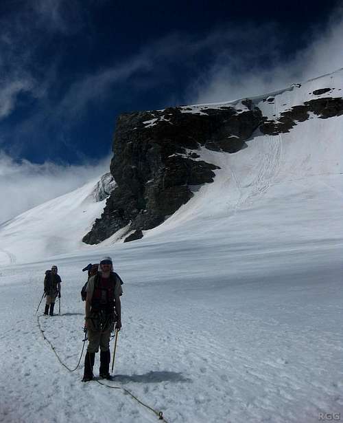
Close to the Schwarztor, with (a very small part of) Breithorn in the background. Though hard to see in this light, the Rossi e Volante shelter is high on those rocks
South of Breithorn lies the Grande Ghiacciaio di Verra (Ghiacciaio = Glacier), with some serious crevasse zones and icefalls. However, the route isn't complicated and while there are some crevasses to cross, the icefalls lie south of the route. Overall, the somewhat undulating trail loses a bit of altitude during the few kilometers that it takes to get to the Schwarztor (3725m), the saddle between Breithorn and Pollux. If you look up at Breithorn now, you can see the Bivouac Rossi e Volante perched precariously on its slopes.
From Italy
 Rifugio Mezzalama Rifugio Mezzalama |
 Rifugio Guide della Val d'Ayas Rifugio Guide della Val d'Ayas |
From Italy, getting there takes decidedly longer, and for most people this means spending the night before the climb at one of the refuges. The shortest route is from St. Jacques (±1700m) at the end of Val d'Ayas. Follow the trail up the Val de Verra to the north and northeast, passing Rifugio Mezzalama (3004m) on the way to Rifugio Guide della Val d'Ayas (3394m). From there the route continues on the Grande Ghiacciaio di Verra. Route finding is easy; just head east by northeast to the base of the southwest ridge.
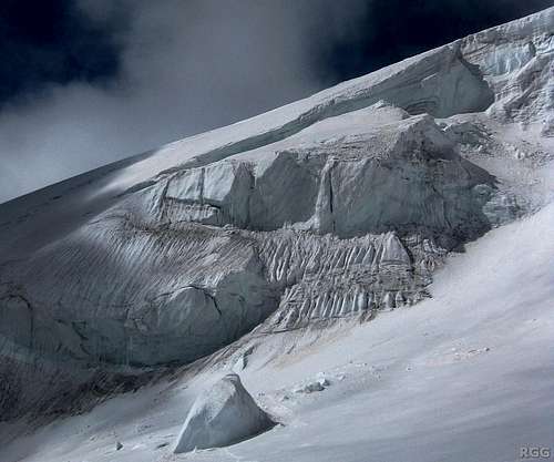
This icefall on the Grande Ghiacciaio di Verra lies next to the route from Rifugio Guide della Val d'Ayas to Pollux
Route Description

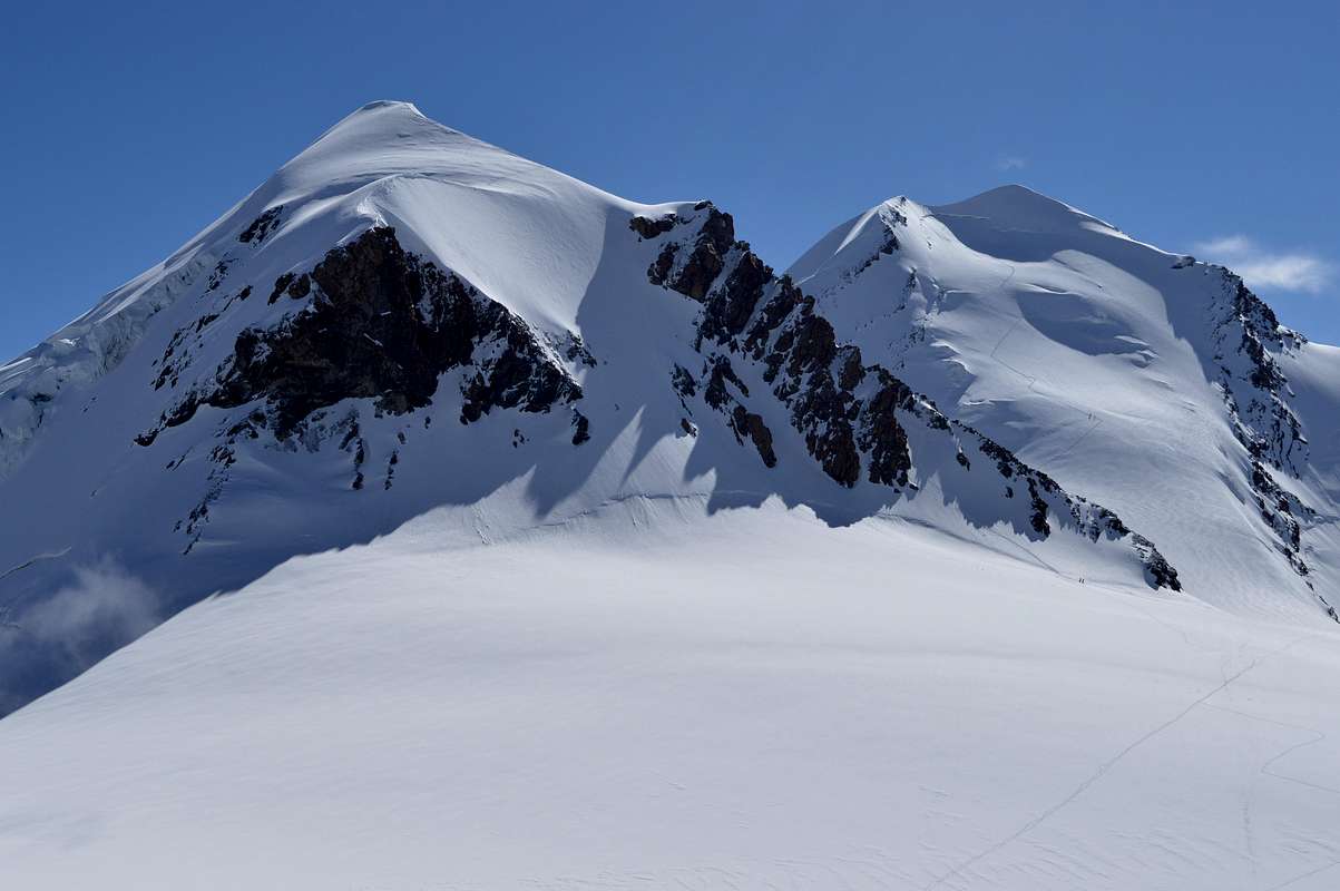
Pollux from the west, with Castor behind it, seen from the Rossi e Volante Bivouac. The SW ridge is shown in profile. On the large original version two trails can be seen on the snow near the base of the ridge. Also visible is a trail heading up the west flank. As usual with a frontal view, it looks steeper than it is.
View down on Pollux from the SE, from the summit of Castor
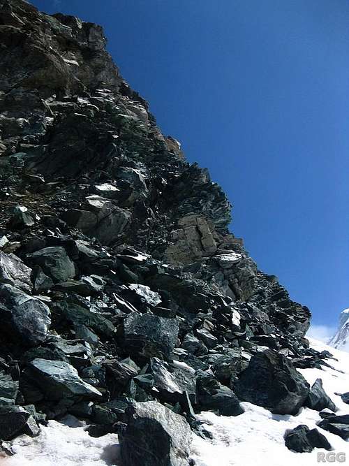
The rocks of the Southwest Ridge rise out of the Grande Ghiacciaio di Verra at just over 3800 m. There may well be some snow on the ridge, in which case you may have to climb on crampons. More snow normally covers all but the steepest areas on the west side of the ridge, while the slightly steeper and sunnier south side has less.
The ridge can be climbed right from the bottom, or alternatively the lowest part of the ridge can be bypassed by ascending the easy snow or scree low on the western side.
At the base of the ridge
At first, climbing the rocks is fairly easy, though the ridge is exposed at a few places. The rocks end at about 3980 m, with a Madonna statue marking the spot. From there an easy but very scenic snow ridge leads straight to the summit. I imagine that, after ascending by a different route, this statue is a useful route marker for the descent if there is no trail on the snow.
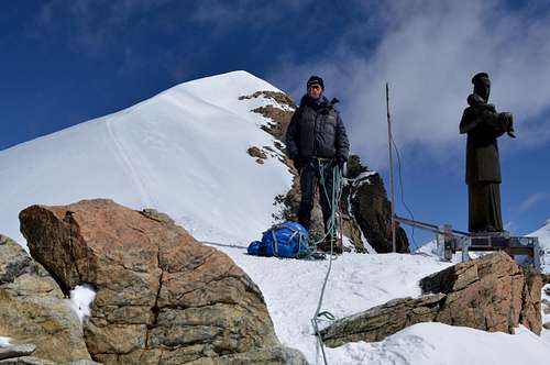
At the Madonna statue
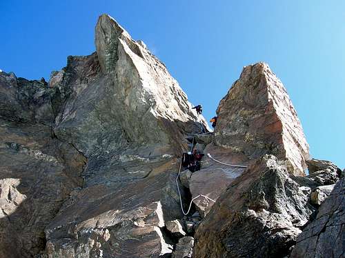
The most difficult section (UIAA rock grade III). Steep, but solid rock.
The crux of the route is the upper part of the rocky ridge. While the rest of the difficulties never exceeed UIAA grade II, there is one fairly short rock step at grade III. There are fixed ropes and/or chains (the situation may vary from year to year) to make climbing the crux much easier. However, on busy days this will be a bottleneck on the climb and you may have to wait quite a while to pass, especially if there are ascending and descending parties at the same time.
Essential Gear
To get to the base of the ridge you'll need glacier travel gear. On the upper part of the rocky ridge, both at the crux and right above it, the lead climber may want to belay the others in your party, so you'll need some gear for that, but no cams or nuts are necessary because there are enough fixed bolts to clip into and to use for a belay.
When to Go
Best when there isn't too much snow on the ridge, which means summer and early fall.
Maps and Books
Maps
| Swisstopo map 1348 Zermatt, 1:25 000. | The most detailed map, but Pollux is right at the southern edge of the map. Only useful when climbing from the Swiss side, and if you accidentally get too far south, you're in trouble. |
| L'Escursionista map ESC08, Monte Rosa - Alte valli d'Ayas e del Lys 1:50 000. | One of several different Italian maps covering the area, including the approach. |
| IGC map 109, MONTE ROSA - ALAGNA VALSESIA - MACUGNAGA 1:50 000. IGC map 108, CERVINO MATTERHORN - BREUIL CERVINIA - CHAMPOLUC 1:50 000. |
Coming from Italy, map 109 should be sufficient, though St. Jacques is just off the map. 108 shows the start of the route. |
Books
Marianne Bauer, Michael Waeber: Gebietsführer Walliser Alpen, Bergverlag Rudolf Rother, München, 14. edition, 2012. ISBN 978-3763324163.
Martin Moran: The 4000m Peaks of the Alps, The Alpine Club, 2012 revised edition. ISBN 978-0900523663
External Links
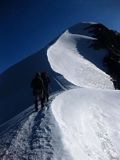 Heading out on the Pollux summit ridge