
-
 2371 Hits
-
 71.06% Score
-
 1 Votes
|
|
Route |
|---|---|
|
|
69.56463°N / 19.33456°E |
|
|
Mountaineering, Skiing |
|
|
Spring, Winter |
|
|
Most of a day |
|
|
Overview
The Southwest Spur is primarily a winter route. Those who have used it in the summer have reported a long tedious slog up loose talus. this slope is actually an excellent ski run in the winter, and is much more pleasant to descend when covered with snow. This is also a faster more direct line to the summit, and is a great ski tour in it's own right, with or without the summit.It also provides the most direct access to the occasional skier with the neccessary skills to descend the opposite side, a steep coulior down the north face.
Getting There
 Southwest Spur. The route goes behind the cliffs in the foreground. Note also the second descent option in the wide coulior that descends directly from the summit.
Whichever way you choose, ascend through the birch forest until coming to a moraine right at treeline. This moraine is perfectly level on top and traverses the entire valley.
Route Description
From the treeline moraine:Stick to the right side of the valley to avoid some of the up and down irregularities in the valley floor. After about 30 minutes under normal conditions, a rise in the valley meets a break in the cliffs to the right. Below is a small lake, frozen for most of the year, and directly ahead is the huge face of Stortind, the subsummit of Bjornskartind. To the left is the summit of Hamperokken and hard left is the Southwest spur. Ascend this spur, keeping to the right hand side to stay in the best snow. Eventually the spur flattens out to the south slope, which you will descend upon your return.
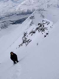 Approaching the summit pinnacle. Note the southwest slope in the background above the climbers head.
Ascend the south slope until reaching the crest of the ridge. From here, follow the Middagsaksle route to the summit OR carefully assess conditions before descending the North Face, which is steep, glaciated, and avalanche prone OR rip off your skins and prepare to descend what you just climbed.
 The upper south slope of Hamperokken.
DESCENT: If descending the route, it is important to NOT descend the actual spur. Head skiers right over the top of the spur, and traverse along Hamperokken's flank, heading for the treeline moraine. This traverse varies from week to week, there are at least 3 large coulior systems to traverse, and one does not want to get too low in the valley too soon, or you'll be poling along the uneven floor.
Descent II: It is possible to carry your skis further up the ridge and ski down from closer to the summit pinnacle. It is steeper, and often lacks enough snow, but it's possible. Skinning up this slope would be difficult, it would be better to boot pack it up. To access this other run from below, cross the lake to the next higher moraine. Follow the moraine to it's left hand edge and ascend straight up the slope. This puts one almost directly below the summit pinnacle.