
|
|
Area/Range |
|---|---|
|
|
46.40400°N / 12.48600°E |
|
|
Hiking, Mountaineering, Trad Climbing, Scrambling, Skiing |
|
|
Spring, Summer, Fall, Winter |
|
|
8360 ft / 2548 m |
|
|
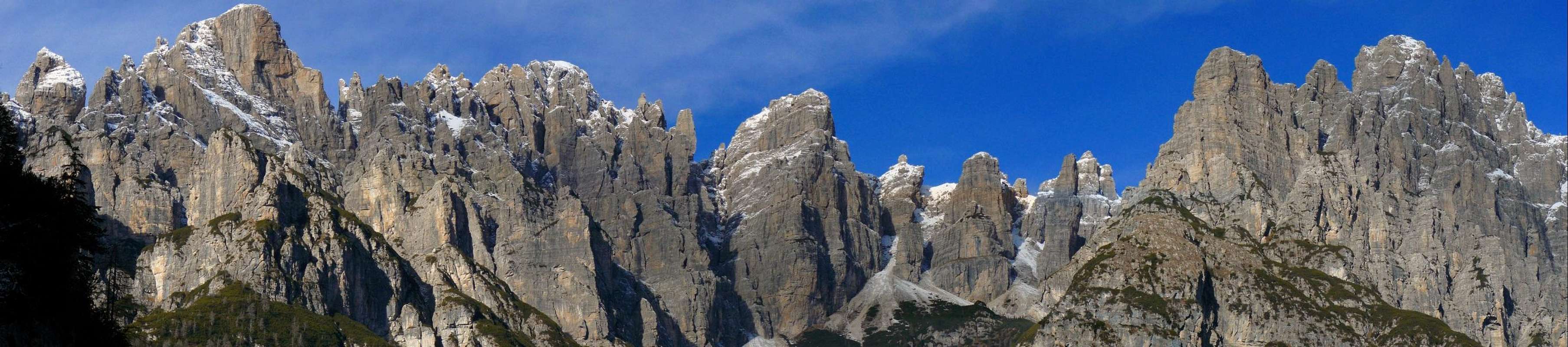
Overview
 Torre Berti
When you look at the picturesque mountains of this group, especially at sunrise or at sunset, when they shine like the most beautiful jewels, you can’t help to forget the small issues of the ordinary life and to think of more high and sublime things. It’s an incredible dolomitic world, but very different from the too touristic area of the nearby “real” Dolomites. A broad part of this range is still very wild and usually is more likely to meet wild animals then hikers or alpinists. The more frequented places are the areas around the four huts ( especially the paths to the Campanile di Val Montanàia ), but if you avoid the weekends of July and august you can enjoy perfect peace also there.
This is mainly an alpinistic group, almost all summits are off-limits for the average hiker. The climbing routes are often difficult to find and the approaches can be very long and strenuous, so many of this mountains are very rarely climbed ( some of them even once every ten or twenty years! ). The quality of the rock is not always good, and many classic routes are considered too dangerous. Actually the area is more frequented by hikers looking for wilderness and spectacular views then by climbers, that prefer more safe and easily approachable routes.
 Sunset
On this rocks the most famous italian rock-climbers put their hands and many fell in love with them. This is what Tita Piaz, “ the devil of the Dolomites “, said about this rocky peaks to Antonio Berti a few months before dying: “ Still today, after many years, the brilliant memory of the hours spent among those peaks seduces me, and I’m moved like only an eccentric semi-savage at the end of a volcanic life can be”.
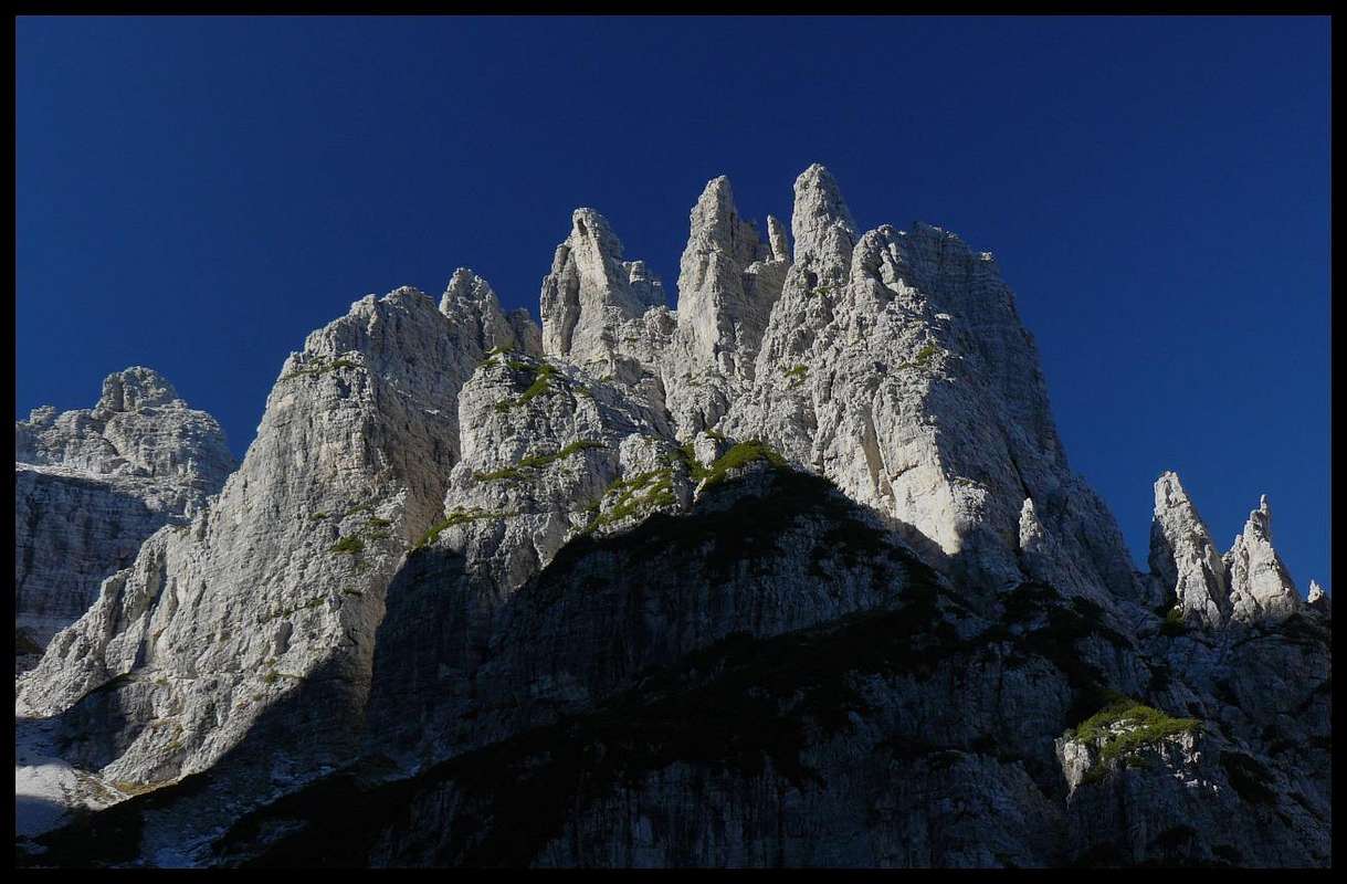
 Spalti di Toro
Campanile di Val Montanàia, Campanile Toro, “Il Castello di Vedòrcia”, “Il Torrione”, Cresta del Leone, Bòcia di Cimoliana… Each one of this mountains, even the smallest tower, is a wonderful work of art, carved in millions of years by the glaciations and the patient work of erosion of the elements. This peaks are a perfect example of how the mountains don’t have to be necessarily 8000 meters high to be beautiful…
The origin and the etymology of the names of this two groups is not clear and there can be more than one interpretation. Spalti di Toro are probably the bastions ( spalti ) of Thor ( the God of thunder worshipped by the Longobards, who lived in the area of Domegge around 1500 years ago ) and Monfalconi should be a contract form of Mons Falcòns ( Monti Falconi ).
Panoramic views
 |
 |
IDENTI-PEAK
 from W from W |
 from SE from SE |
Geography
 Map of the group
This group is situated in the north-east of Italy, between the two regioni Veneto and Friuli Venezia Giulia and among the provinces of Udine, Pordenone and Belluno, in the area known as Carnic Pre-Alps.
It’s an 11 km indented ridge ( direction: south west towards north east ) composed by two main groups ( Spalti di Toro and Monfalconi ) that can be divided in six subgroups ( Ramo di Vedòrcia, Ramo del Castellato, Ramo di Toro and Monfalconi di Montanaìa, Monfalconi di Cimoliana, Monfalconi di Forni ).
The borders are: Forcella Val Misera,Val Anfela, lake of Centro Cadore, Val Talagona, Valle Pra di Toro, Forcella Scodovacca, Val Giàf, Passo Lavinal, Val Binon, Val Meluzzo, Val Cimoliana, Val de Santa Maria, Val Misera.
The average elevation of the main summits is between 2000 and 2500 meters. The highest mountain is the Monfalcòn di Montanàia ( 2548 m ).
Geology
This can be considered the most “dolomitic” area of the Alps even if, as we know, it’s not inside the group of the Dolomiti.The geological structure of the mountains of this group is very simple: they are almost all completely made of the finest dolomite rock, called Dolomia Principale. It’s a sedimentary carbonatic rock formed in the Norian period of the Triassic age ( 220-200 million years ), in the warm waters of the Tethis sea, that would cover a broad area of the African and the Euro-Asiatic continents. In the Paleogene age ( 65-35 million years ) the two European and African plaques collided and the Alps started to rise. In this period terrible earthquakes and climatic changes modified the original structure of the rock fashioning the mountains giving to them picturesque shapes . Then in the Neogene age ( 25-5 million years ) the dolomitic mountains emerged from the sea and a new phase of erosion started . During the long glaciations of the Pleistocene period ( 2-0.01 million years ) this peaks took the shape that we can admire today ( but the dolomitic mountains are constantly changing… ).
| million years | age | period | what happened |
| 0,01 | IV | Holocene | erosion |
| 2 | IV | Pleistocene | disintegration and erosion – last glaciations |
| 24 | III - Neogene | Miocene | emersion from the sea |
| 50 | III – Paleogene | Eocene | alpine corrugation |
| 65 | III - Paleogene | Paleocene | collision Euro-Asiatic and African plaques |
| 220-200 | II - Triassic | Norian | second phase of the dolomitic formation |
Alpinistic history
150 years ago, when the first pioneers arrived to study this group, this area was one of the most remote and wild of the Alps. Nobody would know much about it and there were legends and scary stories about that sharp towers of rock that would light up at sunset above the eastern side of the valley of the river Piave.The first were the botanists and geologists J. Gilbert and G.C. Churchill ( pioneers of the Dolomites and authors of the famous book “The Dolomite Mountains” ) and then F.F. Tuckett ( first on Monte Civetta ), that approached the group from west and went up at the feet of the mountains of Vedòrcia. Then other scientists and alpinists like J. Ball, J. Kugy ( who climbed the nearby Crìdola ), G. Marinelli went to see the group and wrote words of great admiration and amazement for that spectacular peaks and towers.
But only in the last years of the nineteenth century a real alpinistic exploration started. The first mountain climbed was the highest one, the Monfalcòn di Montanàia, by Arturo Ferrucci and a local guide in 1891. Four years later another mountaineer from Friuli-Venezia-Giulia, C. Mantica, climbed other two summits: Cima d’Arade and an unnamed peak that was named after him ( Punta Mantica ).
Then in the first years of the twentieth century many alpinists came to reveal the secrets of that magnificent dolomitic “garden”. The most prestigious peak to conquer was of course the Campanile di Val Montanàia, the amazing hidden jewel of the group. Napoleone Cozzi ( with A.Zanutti ) was the first who tried the difficult ascent on the south face, but had to stop under a roof just before the “gallery”, not knowing that he had already climbed the most difficult passage of the route ( today known as “Cozzi crack” ).
A few days later V. von Glanvell and K.G. von Saar found an easier passage after the crack and reached the summit of the campanile. The two austrian alpinists succeeded because they were great alpinists but also because they followed the indications of Cozzi, and the story of how they got that information is one of the strangest in the history of the alpinism ( what is sure is that they were in a bar drinking good wine…). here is the story described by Melania Lunazzi ( in Italian ).
The more active mountaineers that climbed for the first time the most important summits of the group were: J. Both and F. Koegel, V. von Glanvell, K.G. von Saar, K. Domenìgg, F. Konig, K. Berger and J. Hechenbleikner, G.B. Piaz and B. Treier,G. De Gasperi, G.B. De Santa and G. Feruglio.
Between the two world wars, the best rock climbers of those years came to open more and more difficult routes on this mountains: P. Fanton, A. Tissi, A. Berti, C. Gilberti,R. Carlesso, E. Solleder,G. Gervasutti, E. Castiglioni,S. Casara… Among the exploits of this fantastic mountaineers one was object of an harsh controversy that lasted for more than fifty years. The overhanging yellow-black north face of Campanile di Val Montanàia was considered impossible to climb by all the alpinists of that era and the first attempt by the Fanton brothers in 1913 was unsuccessful. In 1925 the climber from Vicenza Severino Casara announced that he had climbed that repulsive face in perfect free-solo climb, through the famous “spigolo a sega” ( the saw edge).
Some Italian alpinists had doubts about his climb, because looking at that wall it was clear that the difficulty was above the sixth degree ( today is rated VII- UIAA ), and nobody before had climbed routes of that kind. But for a while nobody contested the climb. Five years later another famous italian mountaineer, Attilio Tissi, led an attempt to repeat that route but he couldn’t follow it and had to open an easier variation using nails and artificial helps. After the climb he affirmed firmly that was impossible that Casara could have climbed that route. Many years after two different alpinists, Mazzorana and Dalla Porta Xidias, climbing two separate sections of the route, proved that the climb was possible ( of course with modern gear and roped ), but only Casara knew the truth, and he brought it in his tomb.
In the 50’s a german engineer, W. Herberg, spent many years in the area studying this mountains and, with his climbing partner from Milano V. Altamura, virtually closed the explorative era . Herberg was a very modest man and didn’t want to give his name to one of the unnamed summits that he climbed (he probably named one of them after his daughter Veronica ). Just a few years ago was decided to change the name of Croda di Mezzo ( Crìdola group ) in Cima Herberg.
In more recent years some very difficult routes have been opened in the group and the most famous are the extreme ones of the writer, carver and alpinist Mauro Corona on the overhanging walls of the Campanile di Val Montanàia ( he climbed it almost two hundred times! ). Mauro lives and works in the nearby village of Erto and is a fantastic rock-climber, great passionate of this mountains that he knows better than anyone else.
SPALTI DI TORO
 |
|---|
Ramo di Vedòrcia
 from Monfalcon di Forni from Monfalcon di Forni |
 From Monte Vedòrcia From Monte Vedòrcia |
 Ramo di Vedòrcia map Ramo di Vedòrcia map |
| Cime Cadìn |
| mountain | elevation | normal route | first ascent | Latitude/Longitude | image |
| Cima Cadìn degli Elmi | 2424 m | From SW ( Forcella di Santa Maria )– difficulty around UIAA I | unknown local hunters | 46.387/12.451 |  |
| Cima Cadìn di Vedòrcia | 2403 m | From SW ( Forcella degli Elmi )– difficulty around UIAA II/III | K. Berger-J. Hechenbleikner, 6/19/1903 | 46.390/12.453 |  |
| Cima Cadìn di Toro | 2386 m | From NW ( Forcella Cadin di Toro )– difficulty around UIAA II/III | unknown cartographers | 46.389/12.459 |  |
| Il Castello di Vedòrcia |
| mountain | elevation | normal route | first ascent | Latitude/Longitude | image |
| Torre di Vedòrcia | 2315 m | From S ( Forcella Torre di Vedòrcia )– difficulty around UIAA II/III | K. Berger-J. Hechenbleikner, 7/20/1907 | 46.396/12.461 |  |
| Torre Sud di Vedòrcia | unknown | From S ( Forcella Sud di Vedòrcia )– difficulty around UIAA II/III | K. Berger-J. Hechenbleikner, 7/20/1907 | 46.396/12.461 |  |
| Torre Nord Est di Vedòrcia | unknown | From N ( Forcella Nord )– difficulty around UIAA IV | K.G. von Saar-F. Konig, 8/3/1903 | 46.396/12.461 |  |
| Campanile Olga | 2270 m | From S ( Forcella di Mezzo )– difficulty around UIAA IV | G.B. Piaz – B. Trier, 7/24/1906 | 46.396/12.461 |  |
| Campanile Domegge | unknown | From NE ( Forcella di Mezzo )– difficulty around UIAA III/IV | G.B. Piaz – B. Trier, 8/1906 | 46.396/12.461 |  |
| Collalto | 2039 m | From N ( Val Cadin )– difficulty around UIAA I | G.B. Piaz – B. Trier, 8/1906 | 46.398/12.470 |  |
| Torre di Collalto | 2067 m | From NE ( Forcella di Mezzo )– difficulty around UIAA III/IV | G.B. Piaz – B. Trier, 8/1906 | 46.398/12.470 |  |
 Cima Spe
| Minor summits |
| mountain | elevation | routes |
| Cima Spe | 2314 m | From NE ( Forcella Spe )– difficulty around UIAA I/II |
| Costa Vedòrcia | 2042 m | From N ( Rifugio Tita Barba ) – easy hike |
| Monte Vedòrcia | 1852 m | From S ( Rifugio Tita Barba ) – easy hike |
| Cresta di Santa Maria | 2238 m | From NE ( Forcella di Santa Maria ) – difficulty around I/II |
Ramo del Castellato
 Cima Talagona Cima Talagona |
 From Val Ciòl dal Mònt From Val Ciòl dal Mònt |
 Ramo del Castellato map Ramo del Castellato map |
| mountain | elevation | normal route | first ascent | Latitude/Longitude | image |
| Cresta Piana | 2340 m | From SE ( From Cima Talagona - Forcella della neve )– difficulty around UIAA II | J. Both, 8/23/1902 | 46.390/12.458 |  |
| Cima Talagona | 2429 m | From SE ( Forcella Stretta )– difficulty around UIAA II/III | J. Both-F. Koegel, 8/23/1902 | 46.489/12.461 |  |
| Cima di San Lorenzo | 2363 m | From SW ( Forcella San Lorenzo )– difficulty around UIAA I | K. Domènigg-K.G. von Saar, 8/2/1903 | 46.388/12.464 |  |
| Torre di San Lorenzo | 2385 m | From NW ( Forcella San Lorenzo )– difficulty around UIAA II/III | G.B. De Santa-G. Feruglio-S. Petz, 9/20/1902 | 46.389/12.465 |  |
| Castellato | 2424 m | From NW ( Forcella Cadin )– difficulty around UIAA I/II | K. Berger-J. Hechenbleikner, 7/22/1903 | 46.390/12.467 |  |
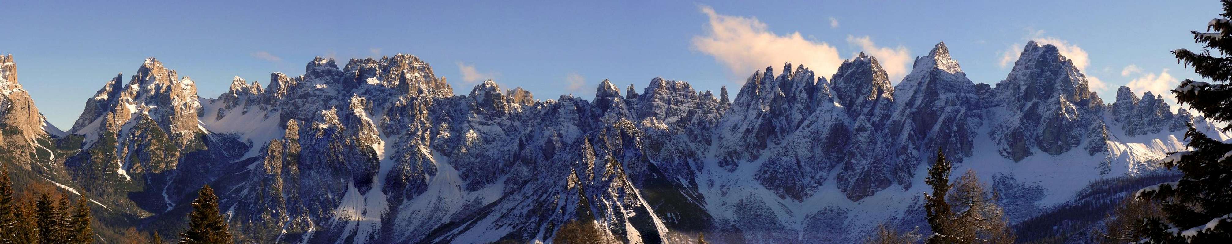
Ramo di Toro
 winter winter |
 Pala Grande Pala Grande |
 Ramo di Toro map Ramo di Toro map |
| mountain | elevation | normal route | first ascent | Latitude/Longitude | image |
| Campanile Toro | 2345 m | From SW ( Forcella Le Corde)– difficulty around UIAA II/III | K. Berger-J. Hechenbleikner 7/22/1903 | 46.391/12.469 |  |
| Pala grande | 2385 m | From SW ( Forcella Cadin )– difficulty around UIAA II | K. Berger-J. Hechenbleikner, 8/22/1903 | 46.394/12.471 |  |
| Guglia Jacek | unknown | From SW ( Forcella Scura )– difficulty around UIAA IV | A. Gozzi-J. Gierlinski-F. Lenarduzzi-R. Bassi, 8/01/1974 | 46.393/12.470 |  |
| Punta Pia | 2347 m | From NE ( Forcella Pia )– difficulty around UIAA II/III | G.B. Piaz-B. Treier, 7/25/1906 | 46.395/12.473 |  |
| Cima Toro | 2355 m | From E ( Val Montanàia )– difficulty around UIAA II/III | G. Morassutti-A. Giordani and P. Hubel-O. Uhland-A. Eichinger, 8/29/1902 | 46.396/12.474 |  |
| Punta Elia | 2251 m | NW buttress( Forcella Segnata )– difficulty around UIAA V | A. Gracis-L. Coletti, 10/26/1969 | 46.397/12.474 |  |
| Cima Rosina | 2369 m | From E ( Val Montanàia )– difficulty around UIAA II/III | L. Lorenzi-G. Faggian-O. Apollonio, 7/15/1962 | 46.396/12.478 |  |
| Cima Emilia | 2424 m | From NE ( Forcella del Campanile )– difficulty around UIAA II/III | J. Both-F. Koegel, 8/21/1922 | 46.401/12.477 |  |
| Cima Both | 2437 m | From NE ( Forcella Montanàia )– difficulty around UIAA II/III | J. Both-F. Koegel, 8/29/1902 | 46.403/12.477 |  |
| Punta Cattaneo | 2242 m | From S ( Forcella della Finestra )– difficulty around UIAA III/IV | L. Tarra-A. Cattaneo, 9/16/1910 | 46.408/12.477 |  |
| Punta Cornelia | 2230 m | From E ( Forcella della Finestra )– difficulty around UIAA II/III | W. and P. Herberg, 7/28/1957 | 46.406/12.476 | |
| Punta 2097 | 2097 m | From NW ( Forcella Montanàia )– difficulty around UIAA I | Schwarz-Seydel-Stummek-Knopf, 8/20/1903 | 46.406/12.480 |
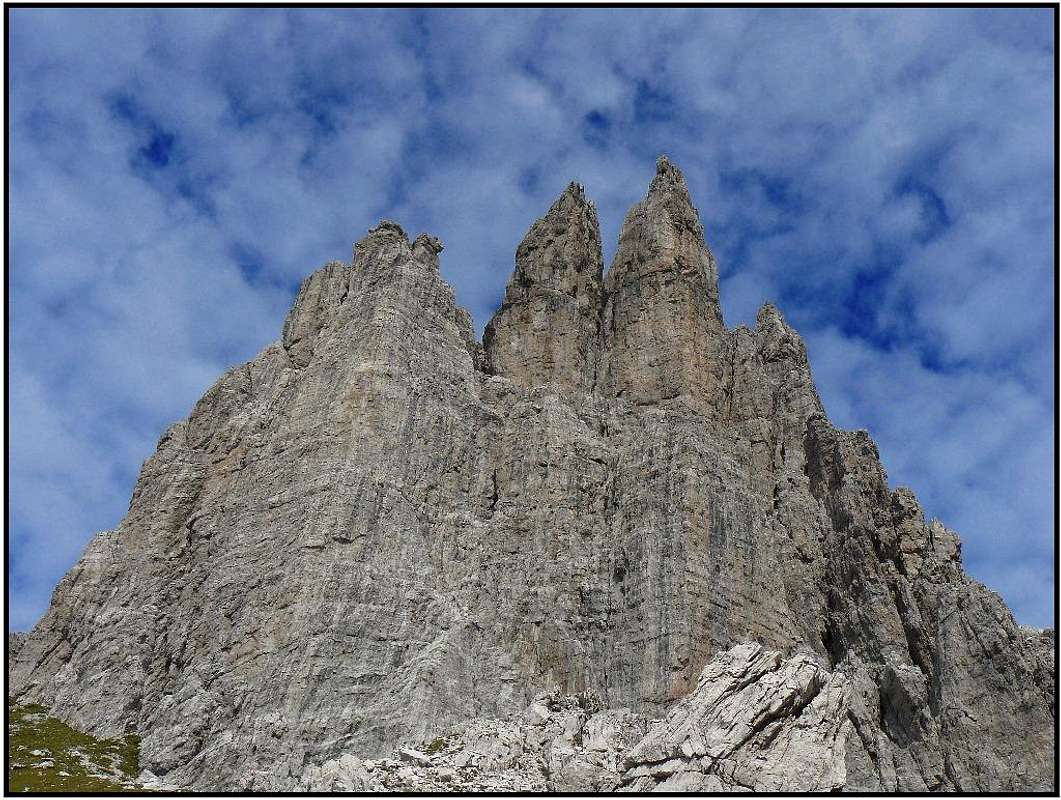
CAMPANILE DI VAL MONTANAIA
“E’ il Campanile più bello del Mondo” ( “ Is the most beautiful spire of the world” )Severino Casara
|
|
|---|


| mountain | elevation | normal route | first ascent | Latitude/Longitude | image |
| Campanile di Val Montanàia | 2173 m | South face – difficulty UIAA III/IV and V- | V. von Glanvell-K.G. von Saar, 9/17/1902 – First female ascent: Mary von Glanvell and Titty Angerer, 10/21/1903 – First winter ascent: O. Soravito-A. Di Prampero, 02/1932 ( normal route ) - S. Dalla Porta Xidias-E. Rocco, 02/23/1944 ( north face ) | 46.387/12.451 |  |
 From East
| Famous routes |
| face | difficulty | opened by | year |
| south | V+ | P. Beltrame-P. Ivo | 1984 |
| south | VIII- | M. Corona-G. Bottino-A. Moret-E. Bravin | 1994 |
| east | VII | P. Cetin-S. Dalla Porta Xidias | 1955 |
| east | VI+ | R. Carlesso-M. De Zanna | 1961 |
| east | VIII- | M. Corona-A. Gogna | 1992 |
| north | VI- | P. Toso-G. Faggian | 1959 |
| north | VII- | S. Casara | 1925 |
| west | VII- | M. Corona-G. Giordani-C. Carratù | 1990 |
| west | VII+ | D. Ulian-C. Scaramuzza | 1969 |
Dialogo con il Campanile di Mauro Corona ( in italian )
MONFALCONI
 |
|---|
Monfalconi di Montanàia
 Monfalcòn di Montanàia Monfalcòn di Montanàia |
 From Torrione Comici From Torrione Comici |
 Monfalconi di Montanàia map Monfalconi di Montanàia map |
| mountain | elevation | normal route | first ascent | Latitude/Longitude | image |
| Cima di Forcella Montanàia | 2520 m | From SW ( Forcella Montanàia )– difficulty around UIAA II/III | P. Hubel-O. Uhland-K. Volkmar, 7/29/1902 | 46.404/12.484 |  |
| Monfalcòn di Montanàia | 2548 m | From E ( Cadin di Cimoliana )– difficulty around UIAA I/II | A. Ferrucci-F. Luzzatto, 8/04/1891 | 46.404/12.486 |  |
| Campanile Stabile | unknown | From E ( Alta Val Monfalcon di Cimoliana )– difficulty around UIAA IV | G. Bianchini-O. Soravito, 8/12/1953 | 46.402/12.486 |  |
| Torre di Forcella Cimoliana | unknown | SE face ( Forcella Cimoliana )– difficulty around UIAA III | G. Bianchini-O. Soravito, 8/12/1953 | 46.401/12.484 |  |
| Cima Eva | 2291 m | From N ( Cadin di Cimoliana )– difficulty around UIAA II | G. Bianchini-M. Micoli, 4/18/1954 | 46.403/12.491 |  |
| Bòcia di Cimoliana | unknown | S face ( Alta Val Monfalcon di Cimoliana )– difficulty around UIAA III+ | E. de Toni-G. Bianchini-E. Villaggio, 4/20/1957 | 46.403/12.488 | |
| Punta Mantica | 2500 m | E face ( Cadin di Cimoliana )– difficulty around UIAA II/III | C. Mantica-A. de Bortoli, 1895 | 46.406/12.487 |  |
| Cima d’Arade | 2503 m | From SE ( Cadin di cimoliana )– difficulty around UIAA II/III | C. Mantica-A. de Bortoli, 9/13/1895 | 46.408/12.488 |  |
| Croda Cimoliana | 2408 m | From N ( Forcella Cimoliana )– difficulty around UIAA III | V. von Glanvell-K. Domènigg-K.G. von Saar, 8/18/1902 | 46.398/12.484 |  |
| Cima Montanàia | 2268 m | From S ( Forcella Meluzzo )– difficulty around UIAA II/III | V. von Glanvell-K.G. von Saar, 8/23/1902 | 46.395/12.484 |  |
| Cima Meluzzo | 2188 m | From N ( Forcella Meluzzo )– difficulty around UIAA II/III | V. von Glanvell-K.G. von Saar, 8/23/1902 | 46.393/12.483 |  |
Monfalconi di Cimoliana
 ”I Leoncini” ”I Leoncini” |
 Monfalcòn di Cimoliana Monfalcòn di Cimoliana |
 Monfalconi di Cimoliana map Monfalconi di Cimoliana map |
| mountain | elevation | normal route | first ascent | Latitude/Longitude | image |
| Punta Koegel | 2440 m | From S ( Cadin di Cimoliana )– difficulty around UIAA II/III | F. Koegel-J. Both, 8/02/1902 | 46.410/12.493 |  |
| Monfalcòn di Cimoliana | 2450 m | From S ( Forcella del Leone )– difficulty around UIAA III | F. Koegel-J. Both, 8/24/1902 | 46.413/12.497 |  |
| Cresta del Leone | 2401 m | From NE ( Val Monfalcon di Forni )– difficulty around UIAA II/III | G. De Gasperi-G. Feruglio, 7/05/1904 | 46.408/12.500 |  |
| Torre Vincenzo | unknown | From NW ( Forcella San Lorenzo )– difficulty around UIAA II/III | G.B. De Santa-G. Feruglio-S. Petz, 9/20/1902 | 46.408/12.501 | |
| Croda Ultima del Leone | 2401 m | From NW ( Forcella San Lorenzo )– difficulty around UIAA II/III | G. De Gasperi-G. Feruglio, 7/15/1904 | 46.407/12.502 |  |
| Cima Stalla | 2100 m | E face ( Forcella Stalla )– difficulty around UIAA II/III | K. Domènigg-F. Konig-K.G. von Saar-V. von Glanvell, 8/17/1903 | 46.395/12.495 |  |
| Cima Bianca | 2175 m | From NW ( Forcella Bianca )– difficulty around UIAA I | G.De Gasperi-G.B. De Santa-G. Feruglio, 9/20/1902 | 46.405/12.506 |  |
Monfalconi di Forni
| Scala Piccola |
| mountain | elevation | normal route | first ascent | Latitude/Longitude |
| La Forchetta | 2216 m | From NW ( Val Pra di Toro )– difficulty around UIAA II/III | O. Bleier-F. Schroffenegger, 9/15/1907 | 46.418/12.484 |
| Cima Anna Paolina | 2330 m | From W ( Forcella Anna Paolina )– difficulty around UIAA II/III | O. Bleier-F. Schroffenegger, 9/15/1907 | 46.418/12.488 |
| Scala Grande |
| mountain | elevation | normal route | first ascent | Latitude/Longitude |
| Antecima della Scala | 2200 m | From E – difficulty around UIAA I | unknown | 46.415/12.485 |
| Torre del Rifugio | 2250 m | From E ( Forcella della Scala )– difficulty around UIAA IV | O. Bleier-F. Schroffenegger, 9/17/1907 | 46.415/12.486 |
| Torre del Verone | 2300 m | From W ( Forcella della Scala )– difficulty around UIAA II/III | O. Bleier-F. Schroffenegger, 9/17/1907 | 46.416/12.487 |
| Torre di Mezzo | 2360 m | From W ( Forcella del Verone )– difficulty around UIAA II/III | O. Bleier-F. Schroffenegger, 9/17/1907 | 46.416/12.488 |
| Torre del Coltello | 2390 m | From S ( Val d’Arade )– difficulty around UIAA II/III | W. Herberg-V. Altamura, 8/2/1953 | 46.417/12.490 |
| Cima della Scala | 2390 m | From W ( Forcella del Coltello )– difficulty around UIAA II | O. Bleier-F. Schroffenegger, 9/17/1907 | 46.417/12.491 |
| Torre Scodovacca | 2440 m | From W ( Forcella Bloccata )– difficulty around UIAA IV | K. Domènigg-F. Konig-K.G. von Saar, 8/26/1906 | 46.418/12.492 |
| Torre Bianca | 2470 m | From W ( Forcella Bianca )– difficulty around UIAA IV | O. Bleier-F. Schroffenegger, 9/17/1907 | 46.418/12.493 |
| Maddalena group |
| mountain | elevation | normal route | first ascent | Latitude/Longitude | image |
| Cima Maddalena | 2410 m | From SW ( Forca Alta di Scodovacca )– difficulty around UIAA II | U. Fanton, 8/14/1910 | 46.420/12.490 |  |
| Torre Valentino | 2300 m | From NW ( Forcella San Lorenzo )– difficulty around UIAA II/III | G.B. De Santa-G. Feruglio-S. Petz, 9/20/1902 | 46.421/12.494 |  |
| Coston di Forca Alta | 2290 m | From SW ( Forca Alta di Scodovacca )– difficulty around UIAA II/III | I. and U. Coradazzi Bianchi, 9/3/1948 | 46.419/12.494 | |
| Cima Bianchi | 2270 m | From SW ( Forca Alta di Scodovacca )– difficulty around UIAA II/III | A. Hennig-T. Hillinger-V. Raitmayr-H. Reingruber,7/11/1927 | 46.420/12.495 |  |
| Cima Chiesa | 2240 m | From SW ( Forca Alta di Scodovacca )– difficulty around UIAA II/III | A. Hennig-T. Hillinger-V. Raitmayr-H. Reingruber,7/11/1927 | 46.420/12.496 |  |
| Torre Antonio Berti | 2155 m | From N ( Forcella Scodovacca )– difficulty around UIAA III | U. Fanton-A. Andreoletti, 8/19/1911 | 46.421/12.497 |  |
| Giàf group |
| mountain | elevation | normal route | first ascent | Latitude/Longitude | image |
| Cima Giàf | 2523 m | From NW ( Forca Alta di Scodovacca )– difficulty around UIAA II/III | L.Patera, 8/12/1900 | 46.418/12.492 |  |
| Crodòn di Giàf | 2504 m | From NW ( Forca Alta di Scodovacca )– difficulty around UIAA II/III | L. D’Agostini-G.B. De Santa, 9/27/1901 | 46.418/12.494 |  |
| ”Il Sigaro” | 2450 m | From SW ( Forcella Sigaro )– difficulty around UIAA III/IV | K. Domènigg-V.W. von Glanvell-F. Konig-K.G. von saar-T. Angerer, 8/6/1902 | 46.417/12.494 |  |
| Monfalcòn di Forni | 2453 m | From SW ( Forcella Monfalcon di Forni )– difficulty around UIAA II | H. Steinitzer-R. Reschreiter, 8/2/1900 | 46.417/12.497 |  |
| Ramo del Torrione-Urtisiel |
| mountain | elevation | normal route | first ascent | Latitude/Longitude | image |
| ”Il Torrione” | 2335 m | From S ( Forcella del Torrione )– difficulty around UIAA II | G. Antoniacomi-I. Coradazzi Bianchi-E. Pavoni-A. Perissutti, 7/20/1929 | 46.415/12.500 |  |
| Cima Barbe | 2303 m | From S ( Val Monfalcon di Forni )– difficulty around UIAA III/IV | G. Antoniacomi-A. Perissutti, 1930 | 46.413/12.512 |  |
| Cima Biasutti | 2280 m | From S ( Val Monfalcon di Forni )– difficulty around UIAA II/III | L. Patera, 1900 | 46.412/12.513 |  |
| Cima Portòn di Monfalcòn | 2342 m | From S ( Val Monfalcon di Forni )– difficulty around UIAA II | L. Patèra, 8/13/1900 | 46.411/12.515 |  |
| Cima dei Pecoli | 2352 m | From E ( Forcella dei Pecoli )– difficulty around UIAA I/II | G. De Gasperi-G. Feruglio | 46.411/12.516 |  |
| Cima Urtisièl Ovest | 2264m | From SE ( Valmenòn )– difficulty around UIAA II/III | V.W. von Glanvell-K.G. von Saar-K. Domènigg-F. Konig-T. Angerer, 8/14/1903 | 46.410/12.523 |  |
| Cima Urtisièl Est | 2119 m | From W ( Forcella Urtisiel )– difficulty around UIAA I | unknown cartographers, 1888 | 46.413/12.531 |  |
| Minor summits |
| mountain | routes | image |
| Torre Alfonso | N-NE face – difficulty V |  |
| Campanile Claudia | North face – difficulty UIAA VII- |  |
| Torre Gilberti | unknown |  |
| Torre di Forni | via “Rai dai Tavaius” ( north face ) – difficulty UIAA VI |  |
| Torre Francesco | North face – difficulty | |
| Torre Bassa | From NE – difficulty around UIAA III/IV | |
| Cime del Lavinàl 2040 and 2063 | From Casera Val Binòn ( S ) – easy hikes |
Hiking around the group
If almost all the summits of this group are quite difficult to climb, this doesn’t mean that hikers can’t enjoy the wild beauty of this fantastic cathedrals of rock. There are very nice paths through picturesque spires and notches that can really take your breath away. Here is a short list of the most interesting ones:| description | marked path n° | hours | views to |
| From Rifugio Pordenone to the basin of Campanile di Val Montanàia | 353 | 2 | Brica group,Torri Postegàe, Spalti di Toro, Campanile di Val Montanàia and Monfalconi di Montanàia |
| From Rifugio Padova to the basin of campanile di Val Montanàia ( through Forcella Segnata ) | 357 | 3 | the whole western branch of Crìdola, Spalti di Toro, the Dolomiti Orientali, Campanile di Val Montanàia and Monfalconi di Montanàia |
| From Rifugio Padova to the basin of campanile di Val Montanàia ( through Forcella Montanàia ) | 346-342-353 | 3.30 | the western branch of Crìdola, Spalti di Toro, Monfalconi di Forni, Monfalconi di Cimoliana, Monfalconi di Montanàia and Campanile di Val Montanàia |
| From Rifugio Giàf to Rifugio Padova ( through Forcella Scodovacca ) | 346 | 3.30 | all the groups of Monfalconi di Forni, Monfalconi di Cimoliana, Crìdola and Spalti di Toro |
| From Rifugio Giàf to Bivacco Marchi Granzotto ( through Forcella del Cason ) | 342 | 2 | Crìdola, Monfalconi di Forni, Monfalconi di Cimoliana and Pramaggiore group |
| From Rifugio Pordenone to Bivacco Marchi Granzotto ( through Forcella del Leone ) | 349 | 3 | Pramaggiore group, Monfalconi di Cimoliana, Monfalconi di Montanàia and Monfalconi di Forni |
| From Rifugio Padova to Bivacco Marchi Granzotto ( through Forcella Monfalcòn di Forni ) | 346-342 | 3 | the western branch of Crìdola, Spalti di Toro, Monfalconi di Cimoliana, Monfalconi di Montanàia , Monfalconi di Forni and Pramaggiore group |
| From Rifugio Padova to Rifugio Pordenone ( through Forcella Segnata ) | 357-353 | 4.30 | the western branch of Crìdola, Spalti di Toro and Monfalconi, Dolomiti Orientali, Campanile di Val Montanàia, Pramaggiore group |
| From Rifugio Padova to Rifugio Tita Barba | 352 | 2.30 | the western branch of Crìdola, Spalti di Toro and Monfalconi |
| From Rifugio Tita Barba to Bivacco Gervasutti ( through Forcella Spe ) | 350 | 3 | the western branch of Crìdola, Spalti di Toro and Monfalconi, Cima dei Preti group, Pramaggiore group |
Huts and Bivouacs
| Huts |
| mountain hut | valley | elevation | how to get there | owned by | Tel. number |
| Rifugio Giàf | Val Giàf | 1405 m | 2 kms by car from Chiarandenis village- Forni di Sopra and then a 30 minutes hike to the hut ( path. N°346 ) | Comune di Forni di Sopra | 0433.88002 - e-mail: rifugio.giaf@libero.it |
| Rifugio Padova | Val Pra di Toro | 1300 m | From Domegge di Cadore 7 kms by car through Val Talagona or 3 hrs by foot | Comune di Domegge di Cadore | 0435.72488 |
| Rifugio Tita Barba | Malga Vedòrcia | 1821 m | 2 hrs ( path n° 350 ) from Domegge di Cadore (loc. La Faghera ) | private | 0435.32902 |
| Rifugio Pordenone | Val Meluzzo | 1249 m | from Cimolais 13 km by car through Val Cimoliana | CAI Pordenone | 0427.87300 |
| Bivouacs |
| name | elevation | place |
| Bivacco Marchi Granzotto | 2152 | Val Monfalcon di Forni |
| Bivacco Perugini | 2060 | Cadin di Val Montanàia |
| Bivacco Gervasutti | 1940 | eastern slopes of Cresta de Santa Maria |
Getting there
1) Rifugio Padova ( 7 km by car from Domegge di Cadore/south east side of the lake ) - Rifugio Tita Barba ( marked path 350 from La Faghera, reachable by car from Sottocastello-Chalet Miralago )2) Rifugio Giàf ( From Forni di sopra-Chiarandenis village 2km by car and then a short hike of 20/30 min to the hut. Marked path 346 )
3) Rifugio Pordenone ( 13 km by car from Cimolais )
From east:
From the UDINE-TARVISIO motorway exit CARNIA and then Tolmezzo, Villa Santina, Forni di Sopra (2), Passo della Màuria , Lorenzago and Domegge di Cadore (1)
Or
From the UDINE-TARVISIO motorway exit Gemona and the S.daniele, Maniago, Barcis, Cimolais, Rifugio Pordenone (3)
From west:
From the BRENNERO motorway exit BRESSANONE/BRIXEN and then Dobbiaco, Cortina d'Ampezzo, Pieve di Cadore, Domegge di Cadore (1), Lorenzago , Passo della Màuria and Forni di Sopra (2)
Or
From the BRENNERO motorway exit BRESSANONE/BRIXEN and then Dobbiaco, Cortina d'Ampezzo,Longarone, Cimolais, Rifugio Pordenone (3)
From south:
From Venezia to Belluno , Pieve di Cadore, Domegge di cadore (1), Lorenzago , Passo della Màuria and Forni di Sopra (2)
Or
From Venezia to Belluno and then Longarone, Cimolais, Rifugio Pordenone (3)
From north:
From Passo di Monte Croce Carnico to Tolmezzo. Villa Santina, Forni di Sopra (2), Passo della Màuria , Lorenzago and Domegge di Cadore (1)
From S.Candido to Passo di Monte Croce Comelico, Cortina d'Ampezzo, Pieve di Cadore, Domegge di Cadore (1), Lorenzago , Passo della Màuria and Forni di Sopra (2)
Or
From S.Candido to Passo di Monte Croce Comelico, Cortina d'Ampezzo, Longarone, Cimolais, Rifugio Pordenone (3)
When to climb?
The best season is from may-june to September-october. Winter ascents are possible but difficult with very long approaches ( the roads to the huts are usually iced and very dangerous in the winter season ).Meteo
Veneto weather forecast
Friuli weather forecast
Eastern Alps weather forecast
webcam Forni di Sopra
Red Tape
The eastern part of this group is inside the Parco delle Dolomiti Friulane . There are no fees to pay or particular restrictions ( camping is not allowed ), but remember that here we like to keep the nature intact so don't trow away anything and respect plants and wild animals.Accomodation
You can easily find accommodation in the villages at the three corners of the group ( Cimolais, Forni di Sopra, Domegge and Pieve di Cadore ).Forni di Sopra Hotels
Camping Forni di Sopra
Camping Domegge
Cimolais hotels
Pieve di cadore hotels
Domegge di cadore hotels
Maps and books
Tabacco 1:250001) 021 Dolomiti di Sinistra Piave
2)002 Forni di Sopra-Forni di Sotto-Ampezzo-Sauris
3)016 Dolomiti del Centro Cadore
4) Parco naturale delle Dolomiti friulane
A. and C. Berti - Dolomiti Orientali vol. II - C.A.I. - T.C.I.
G.Buscaini – Le Dolomiti Orientali - Zanichelli
J.Gilbert – G.C. Churchill - Montagne Dolomitiche – Nuovi sentieri editore
S. Fradeloni - Dolomiti di sinistra Piave e Prealpi Carniche - Edizioni Dolomiti
I. Zandonella - 50 escursioni in Val del Piave - Edizioni Tamari
L. Visentini - Dolomiti d'Oltre Piave - Escursionismo e vie normali sulle cime dei gruppi del Cridola, Spalti di Toro e Monfalconi - Athesia Editrice
K. Von Saar and K. Dominigg - Alla scoperta delle Prealpi Carniche - C.A.I.
S.Dalla Porta Xidias - Addio al Campanile – Luca Visentini Editore
Fondazione Berti - Antonio Berti cantore delle Crode – Nuovi sentieri editore
S.Dalla Porta Xidias - Montanaia.Cento anni di storia e di segreti – Nuovi sentieri editore
Danilo Pianetti - L’avventura dolomitica di Victor Wolf von Glanvell – Edizioni Ghedina Cortina
C. Ferri - Alpi Carniche e Dolomiti Friulane - Itinerari alpinistici dell'ottocento - " Le guide " - Editrice Goriziana
M. Lunazzi - Le Dolomiti Friulane negli acquarelli di Napoleone Cozzi - Nuovi Sentieri Editore
M. Lunazzi - Ardimenti e incantevoli ozi - Nuovi Sentieri Editore
A.Gogna-M.Milano-F.Raiser - I grandi spazi delle Alpi - Vol.8 – Priuli e Verducca Editori
R.Pedrotti - Dolomiti Orientali - Manfrini
I.Zandonella Callegher - Dolomiti del Piave - Athesia
F.Hauleitner -Dolomiti sconosciute - Athesia