
|
|
Mountain/Rock |
|---|---|
|
|
44.89036°N / 110.33526°W |
|
|
Park |
|
|
Hiking |
|
|
Spring, Summer, Fall, Winter |
|
|
8864 ft / 2702 m |
|
|
Introduction
 Specimen Ridge and the Grand Canyon of the Yellowstone.
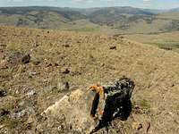 Fallen petrified log.
What makes this ridge unique is its petrified forest on its northern slope. This forest is the world's only standing petrified forest with root systems intact. And unlike the other attractions at Yellowstone, this one is little known to most visitors and so crowds are non-existent especially via a non-standard route.
An additional bonus is the view from the top of the ridge. While nothing spectacular, the ridge is certainly an excellent vantage point of Lamar Valley and the Yellowstone River. Bring binoculars if available to spot wildlife from long range. Lamar Valley is well known for being full of wildlife ranging from bears to bison to elk and even moose.
Location
 Giant, half-buried log.
Distances and elevation gain are one way to the petrified forest.
Specimen Ridge Trail
3.2 miles / 1700'
This "standard route" is the least steep trail to Specimen Ridge. It is also the longest. The trail is the only well-marked trail to the ridge with a large parking lot a few miles east of the junction. The trail climbs along the top of the ridge, reaches the petrified forest, then continues on to Amethyst Mountain eventually descending down into Lamar Valley to the Soda Butte Trailhead.
 Whistling bird making its journey through the grass.
Specimen Fossil Forest Trail
1.4 miles / 1750'
The mileage/gain combination should be a dead giveaway to what the trail is like. The trailhead is "signed" by the National Park Service simply as "Trailhead" and the parking lot is a pullout just west of the Lamar River Bridge. The trail starts off relatively easy for about 0.2 miles on an old dirt road used by the park in the 1980's to slaughter elk whose population was booming due to the non-existence of wolves. After passing an elk antler on a rock, the trail charges straight up the side of the ridge. No switchbacks. Actually, there is one switchback cutting through a grove of trees near the top that almost seems to head down until it loops back up. The trail continues up to a small summit on top of the ridge marked by another elk antler. Continue a little further and meet up with the Specimen Ridge Trail.
Shortcut to Specimen Fossil Forest Trail?
1 mile? / 1750'?
Looking down from the Specimen Fossil Forest Trail appears to be another trail whose full length is visible from the top. The trail begins at an unsigned pullout halfway between the Specimen Ridge Trail and the Specimen Fossil Forest Trail. Whoever uses it will sure get a workout from it based on the incredible steepness of the trail as viewed from above. It links up with the Specimen Fossil Forest Trail after climbing on top of a "sub-ridge".
Park Fees & Rules
 Looking down into Lamar Valley. Notice the line of birds walking through the grass.
Yellowstone & Grand Teton National Parks charge an entry fee of $25 per vehicle good for 7 days at both parks. An annual interagency pass for all federal lands is $80.
Standard national park rules apply. Stay at least 300 feet from wildlife. Despite their calm appearance, bison and elk are both very aggressive and will charge if disturbed.
DO NOT TAKE ANYTHING. The petrified wood is protected. The area is also a source of opal and amethyst (hence the name Amethyst Mountain). These are to be left in the park intact if found.
"Leave nothing but footprints. Take nothing but photographs."
Camping
The nearest campground is at Tower Falls about 5 miles from the Specimen Ridge Trailhead. No reservations are accepted. For a campground accepting reservations, see either Canyon Campground or Mammoth Hot Springs both about 25 miles away. Backcountry camping requires a permit that should be reserved far ahead in advance. As always, take precautions against bears.Geology
Specimen Ridge has not one but actually 27 distinct petrified forests on top of each other all created following burial in volcanic ash and debris from when the Yellowstone volcano erupted. These petrified forests became exposed through centuries of weathering which continues today. Eventually, with the next eruption, the current living forest will become another layer fossilized in time.Links
Yellowstone Tower Area - Hiking in the Tower-Roosevelt area of YellowstoneThe Yellowstone Petrified Forests - Detailed geology on the area and the forests
Bob Sihler - Aug 27, 2010 8:32 pm - Voted 10/10
Good pageLots of useful and interesting information. I hiked up the SR trail once myself and had thought about doing the whole Amethyst-Specimen trip this past summer. The elevation, though, is higher than you list. It's around 8800'. It's hard to say where Specimen Ridge ends and Amethyst begins, but if you look here-- http://www.topoquest.com/map.php?lat=44.84734&lon=-110.28826&datum=nad83&zoom=2&map=auto&coord=d&mode=zoomin&size=l-- you'll see 8800'+ where the map labels it as Specimen Ridge. Thanks for adding this page. It's a nice peak in a nice area; I did nearby Druid Peak and Mount Norris myself back in early July.
Cedar - Aug 27, 2010 8:55 pm - Hasn't voted
Re: Good pageThank you. I was looking through the list of peaks looking for one with significant prominence except there was none. Even Wikipedia contradicts itself by saying "Specimen Ridge, el. 8,574 feet (2,613 m) is an..." and then "Elevation 8,379 ft (2,554 m)?[1]" so it's all confusing. I consider the ridge to end on top of Amethyst Mountain and was thinking about putting the top at 9614' (top of Amethyst). The 7961' is the elevation of the peak right above the petrified forest which, further to the north, shows a massive drop. Wikipedia (the second elevation) seems to have come from USGS. Should I use that, the current value, that of Amethyst or something in the 8800's?
Bob Sihler - Aug 28, 2010 8:39 am - Voted 10/10
Re: Good pageI think I'd go with 8864', the highest I can find where the map is clearly marked as Specimen Ridge. Just to the right of "Ridge" is a 9003' point, but that's awfully close to Amethyst proper. I wish I'd gone as far as you did and seen all those logs. Instead, I turned onto Agate Creek Trail to check out the views of the Grand Canyon. On Druid and Norris, there was a ton of wood, but no logs were anywhere close to as large as some of those your page shows.
Cedar - Aug 28, 2010 12:59 pm - Hasn't voted
Re: Good pageOkay then, I moved it up to 8864. When I went up, I used the "Specimen Fossil Forest Trail" (name according to one of the sites I visited) due to a lack of time. (only had about 3 hours) I actually went up way beyond the fossil forest and found just broken shards wondering where everything was. And then on the way down, I noticed another trail branching off for a little while and discovered some of the huge logs. I think it's because I missed a switchback on the trail (and the forest was presumably on the other end) since there were no switchbacks before then. But at least there were some great ones not in the "big" forest.