
|
|
Mountain/Rock |
|---|---|
|
|
48.13020°N / 120.7649°W |
|
|
8392 ft / 2558 m |
|
|
Overview
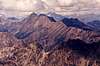
Put on your spectacles because we're going to go searching in the deep Cascades rough for a diamond of a peak. Actually, two peaks: South Spectacle Butte (8,392 ft) and North Spectacle Butte (8,080+ ft). I always thought these two peaks had awkward names when referring to them as South This and North That. But as a unit the name sounds interesting: Spectacle Buttes. Another factor lending to the awkwardness is that the southern butte is a member of the Washington Top 100 where as the north butte is not (but the north butte is a member of the Top 200). Really, these are two separate mountains separated by a deep saddle (7,280+ ft). They are located entirely within the Entiat River drainage about 2.5 miles east of the higher Mt. Maude and 4 miles west of Pinnacle Mountain.While the two mountains share a common geology (gneiss of the Seven Fingered Jack pluton) and name, visually the two peaks have vastly different forms. South Spectacle appears as a great four-sided pyramid from most angles. It is easily distinguishable from many directions. However, North Spectacle has the appearance of a stump, as if Paul Bunyan lopped off its summit. Neither peak is a walk in the park. In particular, South Spectacle is everywhere rugged. Yet, I located a route on the North Face that offered little resistance to my travels. North Spectacle looks to be easiest from the west (from Ice Lakes) or from along its NE Ridge. I did not climb North Spectacle for two reasons:
1) Fred Beckey's description of the route from the central saddle is wrong. He refers to the climb from there as not being difficult. However, it looked like at least Class 4 to me. John Roper later told me that it is mostly Class 3 but with a definite Class 4 section to it.
2) After having done South Spectacle via its irritatingly difficult NW Ridge from that central saddle, I had no wish to return that way. Instead I descended the North Face, which put me on the NE Shoulder of South Spectacle appreciably distant from the saddle. Since I was going the other way (east back to my camp below Pinnacle Mountain), I had no desire to make the traverse back over there.
 |  |  |  |  |
Getting There
There are three general trail approaches to the immediate vicinity of Spectacle Buttes: A) The Entiat River Trail to the Ice Lakes Trail, B) The Entiat River Trail to the Cool Creek Trail, and C) from Leroy Creek Basin to Ice Lakes by way of the divide south of Mt. Maude. Each of these will be treated below. There is a fourth way from the Carne Mountain High Route that I will omit here as it is uncertain terrain (I don't think that trail is maintained). It starts from the Phelps Creek Trailhead, climbs up to Carne Mountain, then traverses north close to the ridge all the way to Ice Lakes.To get to the Entiat River Trail, exit Alt.US-97 just south of the town of Entiat on the west side of the Columbia River and take the Entiat River Road northwestward. Keep on the road (paved for most of the way) for 38 miles to its end just past Cottonwood Camp. Elevation = 3,140 ft.
To describe how to get to the Phelps Creek Trail, let me shamelessly quote Bob on his Maude page: "For the Chiwawa River / Phelps Creek / Leroy Creek approach, drive east from Stevens Pass or west from Leavenworth on US Highway 2 and turn north toward Lake Wenatchee. After the Wenatchee River bridge go right at a Y, then drive 1.1 miles on county road 22 and turn left on Chiwawa River forest road number 62. Drive 24 miles to near the end of the road and turn right on the Phelps Creek road. Drive to the end of this road to the trailhead."
Ice Lakes Trail Approach
Hike the Entiat River Trail for 8.0 miles to 4,360 ft. At the junction, go left (the main trail keeps straight) to the crossing of Entiat River. Good camping here. The river crossing is currently a log of dubious width. For me, it was a bit wet (from dew and water splashing) on the way up. I worried about it being inundated on the return but it was actually easier despite the awkward first downward step. I'm actually surprised they haven't erected a more worthy (permanent) bridge there.At any rate, after crossing the river, hike the Ice Creek Trail for about 2.5 miles to get to the south base (c. 4,800 ft) of South Spectacle. One could attempt to climb straight up from here. Undoubtedly, a complex corrugation of gullies and ribs (timbered at the bottom dissolving to alpine near the top) should be expected. Or, take the trail for 4 miles from the river crossing to the west side (c. 5,300 ft) of South Spectacle. Turn right (east) and climb the West Ridge to the summit. There are crags along the ridge that will force you off of it to the south side (the north side is cliffy). I've read summit logs that have described this route as difficult for routefinding. (Time = 4 hours via South or West Ridge routes)
Another route would be to hike east into the western basin between the buttes thence up to the central saddle (7,280+ ft). From there, a most unsavory route to the southern butte is via its NW Ridge (ugly Class 4/5 and not recommended). Another route to the southern butte and probably the easiest is to contour across its northern cirque aiming for a prominent shoulder of the NE Ridge (a convenient dirty break in the cliff offers easy access up onto this shoulder). For the remainder of that route, see the North Face Route page. (Time = 5 hours)
A climb of the northern butte from this saddle is also feasible (Class 4 rock at the bottom half easing to Class 3 and Class 2 the higher you go). Or, the easiest route up the northern butte from this side would be along its gentle West Ridge. The Ice Lakes Trail continues up through the cliffs at the head of Ice Creek and eventually arrives at the lower lake (6,822 ft). Turn right (east) here and travel cross-country up onto the ridge then to the summit. Approximately six miles from the Entiat River crossing and 0.6 miles from the lower lake. (Time = 4 hours)
 |  |
Cool Creek Trail Approach
At the Entiat River crossing described above, the Cool Creek Trail junctions off of the Ice Lakes Trail and travels north. The trail parallels the Entiat River for most of a mile. There is a major creek crossing along this stretch (Cool Creek?) that might be the last best water. The trail then climbs up the north side of Cool Creek for a mile or so to about 5,300 ft, whereupon it leaves the creek and angles NW toward a saddle next to Pt. 6693. It is not necessary to go that far. Instead, at about 0.4 miles past where the Cool Creek Camp spur trail junctions off, leave the trail at ~6,000 ft and hoof it cross-country westward toward the southern butte, which will be obvious at the head of the basin. The idea is to trend to the right (north) of the butte aiming for the obvious flat shoulder at 7,640 ft on its NE Ridge. There is a minor set of cliffs to negotiate at ~6,800 ft (Class 3 but obvious routefinding). Pumaceous slopes will be encountered. This is pumice from nearby Glacier Peak. For a description of the remainder of the route from the shoulder, see the North Face Route page. (Time = 4 hours)The easiest way to get to the central saddle between the buttes is to climb to the aforementioned flat NE shoulder then use a dirty gully (easy) to descend into the northern cirque, whereupon a traverse can be made to the saddle (allow an extra 30 minutes from the shoulder). There is no reason to go to this saddle unless you intend to climb the northern butte.
Another possible route for North Spectacle from the Cool Creek Trail is as follows:
From the 7,640+ ft shoulder on South Spectacle's NE Ridge, use the dirty gully on the NW side to descend into the northern cirque. Bear north and drop down into the basin about 600 vertical feet (to about 7,000 ft). Look for a feasible route up talus and minor cliff bands to the NE Ridge of North Spectacle. Once on the ridge, it can be followed without trouble to the summit. (Time = 4-5 hours from the Entiat River crossing)
It would also be possible to keep on the Cool Creek Trail until it drops into that basin. The trail reaches the basin bottom at 5,800 ft about 1 miles ENE of the northern butte. Simply ascend higher into the basin looking for the easiest way to mount the NE Ridge of the butte. Since the terrain is so open for cross-country travel, going this way as compared to up and over the southern butte's NE shoulder is probably about the same distance-wise but a little more in terms of elevation gain required.
Leroy Creek Basin Approach
This is a shorter distance from trailhead to summit as the crow flies but is more circuituous in the route. It may be quicker than the Entiat side or it may not.See the Getting There section for how to get to the Phelps Creek trail. Hike the well-worn Phelps Creek Trail for 3.5 miles to Leroy Creek (good camping at 3.2 miles). On the north side of the creek (4,120 ft), find the climber's trail that ascends steeply northeastward up to Leroy Creek Basin. At maybe about 5,600 ft, leave the trail that continues NE to the upper basin (c. 6,100 ft) 1 mile SW of Seven Fingered Jack. I can't recall, but I believe there is a trail that heads southeast to the 6,840+ ft saddle immediately east of Pt. 7000+. From the Phelps Creek Trail to this saddle it is maybe 2.5 miles. You then want to go east for about 0.4 miles to the 7,600+ ft saddle between Maude and Pt. 8017. From this saddle you will get your first views of Spectacle Buttes out to the east some 2 miles distant. Drop down and skirt Upper Ice Lake (7,188 ft) on its south then find the path down through a short cliff band to Lower Ice Lake (6,822 ft). From the 7,600+ ft saddle to the lower lake it is about 1.5 miles. (Time to lower lake from trailhead = 5-6 hours; distance = 10 miles)
To climb southern butte, find the trail from the lower lake down to the head of Ice Creek. Once sufficiently below the creek headwall below the lakes, leave the trail and bear east to the central saddle. Continue as per Ice Lakes Trail Approach section.
To climb the northern butte, bear east from the lower lake onto the gentle West Ridge and take it all the way to the summit (no difficulties).
Red Tape
This peak resides in the Glacier Peak Wilderness, therefore the "leave no trace" policies, etc. apply here. There would probably also be a Trail Park Pass requirement for the Entiat River trailhead.When To Climb
Spring to fall. |  |  |  |
Camping
See the approach descriptions for campsites. Most of the terrain is fairly open, meaning you could camp just about anywhere. But for the sake of erosion, it is best to select unvegetated ground. There are plenty of campsites along the Entiat River Trail. A known camp of considerable size is at the confluence of Ice Creek and the Entiat River. Cool Creek Camp is located at ~5,400 ft just off the trail as it climbs through the basin east of South Spectacle. Other good camping would be at Ice Lakes or, if you didn't want to go that far, in Leroy Creek Basin. From LCB, it should be possible to get to Spectacle Buttes and back (with a tagging of Mt. Maude on the way by) in a long day. A camp could also be made at Ice Lakes but it's a long schlep.Mountain Conditions
Localized ForecastStehekin weather (the nearest town with weather info)
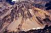
Views from South Spectacle
 |  |