
-
 6551 Hits
-
 88.61% Score
-
 27 Votes
|
|
Mountain/Rock |
|---|---|
|
|
42.87455°N / 96.95885°W |
|
|
Hiking |
|
|
Spring, Summer, Fall, Winter |
|
|
1220 ft / 372 m |
|
|
Overview
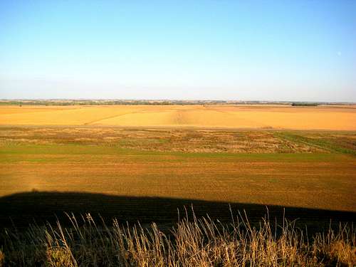 View from Summit
Spirit Mound would be an unremarkable hill almost anywhere. However, it isn’t found just anywhere - - it stands in the middle of the prairie of southeastern South Dakota, a few miles north of Vermillion. As a result, it stands out in the sea of grass and crops though it rises only about 70 feet about the plain. Because of its prominence in an otherwise-flat landscape, there are good views in all directions.
There’s a slight rise to the approach trail, but no more than 100 feet of elevation gain from the parking lot (if that). Obviously it isn’t a serious summit in the usual sense. It’s interesting for historic and cultural reasons, and it’s pretty much the only game in town in southeastern South Dakota. So, if your travels take you near, check it out.
Importance
 Summit of Spirit Mound
Spirit Mound is important for two reasons. First, Spirit Mound (“Paha Wakan”) has long been spiritually important to the Lakhota peoples of the area. They believed that little people lived in the mound and shot any people who came near. Supposedly these little devils are 18 inches high, with very large heads, and have sharp arrows with which they can kill people at a great distance. I have it on second-hand authority that Lakhota elders still report remarkable spiritual energy associated with the mound.
Second, Lewis and Clark climbed the mound in 1804 to take a look around. There are several Corps of Discovery campsites along the Missouri River about nine miles away, and they explored inland from these. Many Lewis and Clark sites are known only approximately, but the summit of Spirit Mound is certainly a place where these explorers once stood.
Natural history
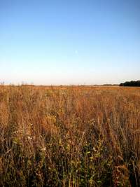 Native Prairie Grasses
Spirit Mound is a bedrock knob that was smoothed out by the last glacier. The glacier dumped till and erratics on the lee (south) side of the mound, which explains why it is a longer and more gentle slope than the north and east.
Lewis and Clark reported a wide plain, with trees visible only along the Vermillion and Missouri Rivers in the distance. Today, it is surrounded by farms, each sitting on about one mile square, and each with a thick shelterbelt on the west and north sides of the farmhouse and other buildings.
Lewis and Clark also saw their first buffalo herd from this point, estimating the number of animals at more than 800. I’m not aware of any nearby buffalo ranches today. The farms are mostly corn and soybeans.
Spirit Mound was privately owned until recently, and was the site of a modern farm and shelterbelt. The Spirit Mound Trust bought the land and began to restore it with the help of the National Park Service and the South Dakota Department of Game, Fish and Parks. It’s an official Lewis and Clark site and lies on the Lewis and Clark National Historic Trail. The National Park Service also includes it in the Missouri National Recreational River unit.
The land managers have begun to restore the native prairie to the 320-acre site. Some of the prairie plants are labeled along the trail, and there are interpretive signs presenting the Lakhota and Corps of Discovery histories of the site.
Route
Lewis and Clark hiked nine miles from the river on a hot August day. Lewis’ Newfoundland, Seamen, was not up to the task and had to turn back. A Wild Time
The modern route is easier, and begins at the parking lot. From there it’s 0.8 miles to the summit up an improved gravel trail. To their credit, the land managers did not put the parking lot at the base (or top) of the mound, but force you to approach it and then circle around to the west and north before reaching the summit. This instills a sense of significance to what is, after all, a 15 minute walk up a hill.
Getting There
Spirit Mound is six miles north of Vermillion, South Dakota, on State Highway 19. It’s easy to find the turnoff from the Highway 50 bypass on the north side of Vermillion, a bit west of the Dakota Dome and the Wal-Mart. Vermillion is about 15 minutes west of I-29 between Sioux City, Iowa, and Sioux Falls, South Dakota.You could also get there by taking Highway 81 south from I-90 into Yankton, and then heading east on Highway 50. Take the bypass around Vermillion and look to your left for State Highway 19.