
|
|
Route |
|---|---|
|
|
63.01000°N / 12.12000°E |
|
|
Hike / Scramble |
|
|
Half a day |
|
|
Exposed walk-up |
|
|
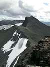
Approach
Take the path westwards accross the stream from Sylarna Fjällstation to Slottsdalen (Slotts-valley) until you reach the second shallow lake at the end of Slottsdalen.
Route Description
From the lake head southwards and up towards Lill Sylen (via the unnamed about 1690m summit) though the easiest route. From Lill Sylen just head for the lowest point on the ridge between Lill Sylen and Stor Sylen and look for red markings (paint) on the stones and then follow them to the top of Stor Sylen.
And easier way to reach the summit is to cross the col at the western end of Slottsdalen to Norway and follow the path that soon turns southwards. The path should be marked with red paint and lead to the ridge between Lill and Stor Sylen.
 |  |
Essential Gear
Nothing much except a pair of sturdy boots, but rainwear is adviced as is a hiking pole(s).
Actually in the autumn good basic alpinewear is adviced, as I got to a snowstorm while hiking there in mid August, we got almost a feet of snow on the ground in less than a half day.
In winter one walking axe is adviced, thoug a hiking pole might suffice.
Miscellaneous Info
If you have information about this route that doesn't pertain to any of the other sections, please add it here.