
|
|
Mountain/Rock |
|---|---|
|
|
40.52000°N / 105.586°W |
|
|
12148 ft / 3703 m |
|
|
Overview
Stormy Peaks is a series of rocky outcroppings on the northeast end of the Mummy Range. This series of outcroppings straddles the border between Rocky Mountain National Park to the south and Comanche Peak Wilderness to the north.
These outcroppings largely consist of big boulders ranging in size from sofas to large trucks. They reminded me a lot of the photos I’ve seen of the peaks in Lost Creek Wilderness (Bison Peak and Windy Peak). They’re very different from the surrounding summits. A cluster of three distinct outcroppings make up Stormy Peaks proper, with the middle outcropping being the tallest at 12,148 ft. However, the ridge descends for about a mile on either side of the summit with similar outcroppings popping up periodically.
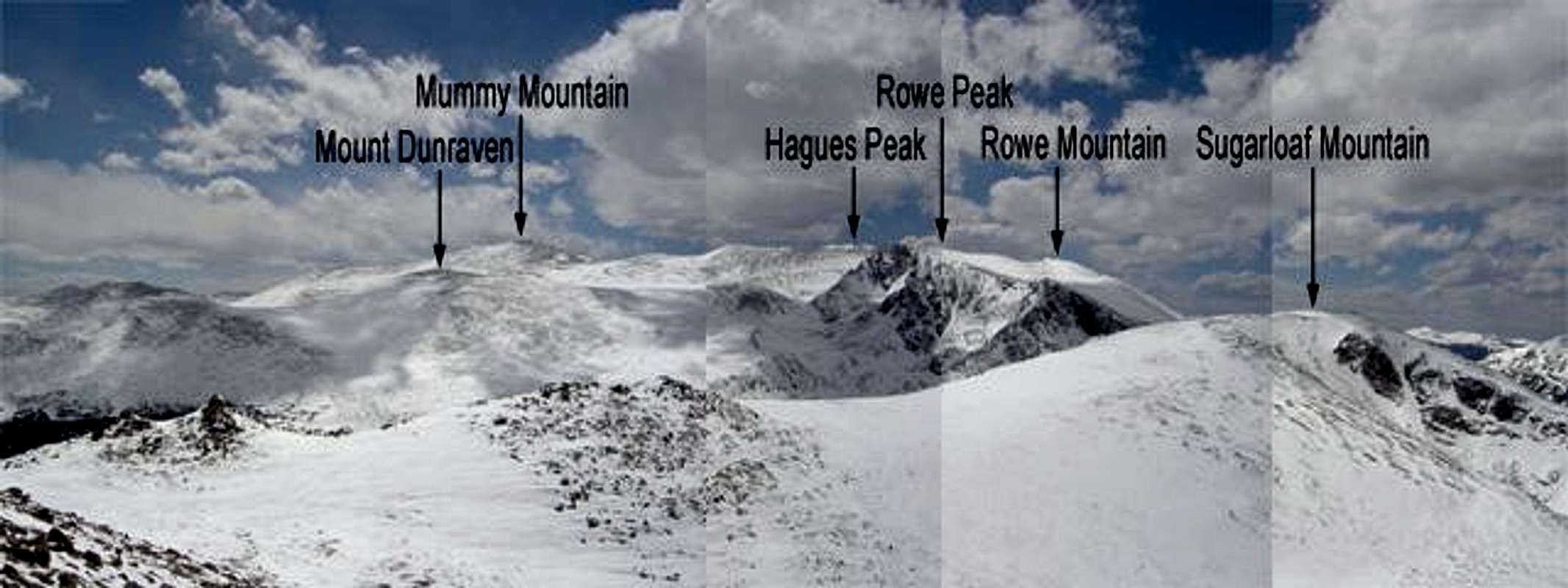
These outcroppings make for fun class 2 and 3 scrambling and the summits offer nice views to the southwest of some of the taller mountains in the Mummy Range including Mount Dixon, Mount Dunraven, Mummy Mountain, Hagues Peak, Rowe Peak, and Rowe Mountain.
 |
 |
 |
 |
Route Overview
All routes to the top of Stormy Peaks are long hikes on maintained trails with some scrambling at the end to reach the summit. There are three logical trailheads that access Stormy Peaks: Stormy Peaks Trailhead to the north and Dunraven Trailhead and Cow Creek Trailhead to the southeast. From Stormy Peaks Trailhead it's approximately 5 miles and 3,000 ft of elevation gain to the summit of Stormy Peaks. From Cow Creek Trailhead it's approximately 9.25 miles and 4,000 ft of elevation gain to the summit of Stormy Peaks. From Dunraven Trailhead it's approximately 7.3 miles and 4,000 ft of elevation gain to the summit of Stormy Peaks.
Getting to Stormy Peaks from anywhere else is going to be one hell of a hike including significant distances of off-trail bushwhacking.
Getting There
There are three logical trailheads you could use to access Stormy Peaks for a day hike. Driving directions are as follows:
- Stormy Peaks Trailhead—There are two ways to get to the Stormy Peaks Trailhead. I've driven both and am still not sure which way is fastest. Here they are:
- Poudre Canyon—From downtown Ft. Collins go north on U.S. 287 to mile marker 22. Turn west on Hwy. 14 going up Poudre Canyon. Stay on Hwy. 14 to mile marker 96 which is the turnoff for Pingree Park (CR-63E). Turn south across the bridge and drive on a gravel road for about 17 miles until you get to Pingree Park. Keep left until you see the trailhead parking lot on your left.
- Pennock Pass—From Ft. Collins, take Harmony west. After you pass Taft Hill, Harmony becomes CR-38E. Take CR-38E past Horsetooth Mountain Park to Masonville. Continue through Masonville and go about 10 miles until you see the sign for Pennock Pass (this is CR-44H). Take CR-44H approximately 15 miles over the top of the pass and down the other side until you run into CR-63E. Turn left on CR-63E and continue up this road until you get to Pingree Park. Keep left until you see the trailhead parking lot on your left. Pennock Pass may be closed in the winter so contact Canyon Lakes Ranger District to make sure it's open if you want to use it during the winter.
- Cow Creek Trailhead--From downtown Estes Park take Highyway 43 (Devils Gulch Road) north out of town. Proceed for approximately 3.75 miles until you see a dirt road angling off to your left. Proceed down this dirt road for approximately 2.25 miles until you get to McGraw Ranch.
- Dunraven Trailhead--From the town of Drake take Highway 43 northwest to Dunraven Glade Road. Turn right on Dunraven Glade Road and follow it until it deadends at the trailhead
 |
 |
 |
 |
When To Climb/Mountain Conditions
Stormy Peaks can be climbed all year round. Access to Stormy Peaks Trailhead is open all year round, though Pingree Park Road is not a first priority for snow removal (I'm not sure about access to the other trailheads). If there is a huge snowstorm you will want to wait a couple of days to allow time for the road to get plowed.
For detailed conditions I recommend contacting the rangers at Rocky Mountain National Park.
 |
 |
 |
 |
Camping
There are many back country campsites to the south of Stormy Peaks (Lost Lake, Lost Meadow, Stormy Peaks South, Sugarloaf, Lost Falls, Happily Lost, Aspen Meadows, etc.) There is one back country campsite on the north side of Stormy Peaks - Stormy Peaks. All of these are within Rocky Mountain National Park and require a permit.
Camping is allowed anywhere in Comanche Peak Wilderness.
 |
 |
 |
 |
Red Tape
No permit is required to climb Stormy Peaks. You will not have to pay park entrance fees if you begin from any of the logical trailheads (Cow Creek, Dunraven, Stormy Peaks). Camping within Rocky Mountain National Park is only allowed in designated campsites and requires a permit.
Camping in Comanche Peak Wilderness is allowed anywhere outside of travel zones. Inside travel zones, camping is only allowed in designated camping spots and fires are not allowed. Permits are not required regardless of whether you camp in a travel zone or not.
Contact Rocky Mountain National Park
The rangers at Rocky Mountain National Park are super-friendly and are happy to answer all your questions. Here is the contact information I pulled off of their website (www.nps.gov/romo).
| email ROMO_Information@nps.gov *e-mail messages will be responded to in the order received and usually within 24 hours of receipt. write to Rocky Mountain National Park 1000 Highway 36 Estes Park, CO 80517-8397 fax 970-586-1256 |
phone Visitor Information 970-586-1206 Visitor Information Recorded Message 970-586-1333 Visitor Information (TDD) 970-586-1319 Backcountry 970-586-1242 Campground Reservations 800-365-2267 |
Contact US Forest Service Canyon Lakes Ranger District
For information regarding Comanche Peak Wilderness, Roosevelt National Forest, Long Draw Road, and Pennock Pass contact the Canyon Lakes Ranger District. Here is the contact info I pulled off of their website (www.fs.fed.us/arnf/districts/clrd).
- Address: 1311 South College, Fort Collins, Colorado 80524
- Phone: (970) 498-2770
- TTY: (970) 498-2727
- Fax: (970) 498-2769