-
 21112 Hits
-
 81.84% Score
-
 14 Votes
|
|
Mountain/Rock |
|---|---|
|
|
39.83141°N / 79.4648°W |
|
|
Fayette |
|
|
Hiking |
|
|
Fall |
|
|
2667 ft / 813 m |
|
|
Overview
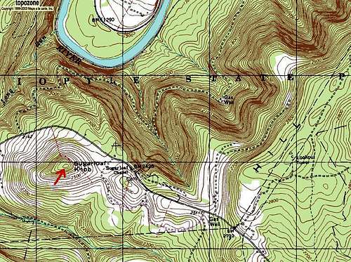
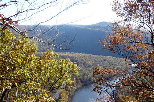
Sugarloaf Knob at 2,667 feet is the highest named peak within Ohiopyle State Park. Just East of Sugarloaf Knob the Laurel Ridge does rise to an elevation of 2,920 feet with no discernible peak.Although impressive from across the river at the 1,900 ft. Youghiogheny Overlook along the Laurel Highlands Trail, it is not nearly as impressive from the nearby overlook at the fire tower road ~2,900 ft.
There are four hiking, mountain biking, snow mobiling trails that all loop around Sugarloaf Knob. However, there is no trail that leads to the heavily forested summit. Therefore, there are no views. There is also the Sugarloaf Trail, a 3.8 mile, difficult trail that begins near the Train Station/Visitor Center. The trail climbs 800 feet in elevation in two steep sections. The trail connects to the main trail bike area near Sugarloaf Knob.
Having said all that, YOU MUST GO TO OHIOPYLE !!! The Hiking, the Biking, the Whitewater Rafting, The Natural Waterslides....It is all the best that Southwestern Pennsylvania has to offer. I've been going several times a year for almost 30 years and I always discover new trails, waterfalls, sights...IT IS THE GREATEST !!!
Ohiopyle State Park is also the southern terminus of the Laurel Highlands Trail. A rugged 70 mile trail that follows the ridgeline from Ohiopyle to Johnstown, PA.

Getting There
Ohiopyle sits at the south east end of the Laurel Ridge along the Youghiogheny River just north of the Maryland and West Virgina Borders.Ohiopyle State Park can be reached from the PA turnpike Donegal Exit and heading south along PA State Routes 31, 711 and 381 or from US Route 40 by heading north on PA 381 out of Farmington, PA.
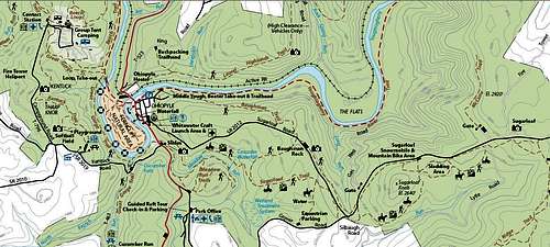
Ohiopyle State Park Information

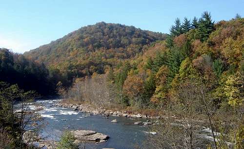
Ohiopyle State Park encompasses about 20,000 acres of rugged natural beauty in the Laurel Highlands. The focal point of the area is the Youghiogheny River, known as the Yough(yawk)that cuts a beautiful gorge through the mountains. The lower Yough provides some of the most popular whitewater rafting in the east as well as beautiful scenery. Right in the town of Ohiopyle along Rt 381 is the Ohiopyle Falls Day Use Area. This area has parking, restrooms, falls overlook platforms and (seasonal) gift shops.
Rails to Trails Biking: The Youghiogheny River Trail has 27 miles of trail in the park and is part of the Great Allegheny Passage. This trail is part of the network that connects Pittsburgh and Washington, DC (via the YRT, GAP and C&O Canal)
Hiking, Biking and Horseback Riding Trails: Plenty to explore with 79 miles of hiking, 13.2 miles of mountain biking trails and 9.4 miles of horse trails.
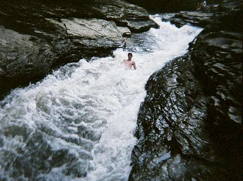
NATURAL WATERSLIDES: Alright Now Listen Up, you MUST check these out. Meadow Run features two natural waterslides areas. They are Mild when the water is low and Wild when the water runs high. Fun for kids of all ages most summer days. But sometimes the park will close down the slides immediately following storms because they are too dangerous. I have personal experience with the natural hazards and how caution must be exercised at all times. Dangerous, but FUN! Parking is available along Rt 381 with steps leading directly to the slides.
Picnicking: Check out the park guide for picnic areas and knock yourself out.
Whitewater Boating: For first time visitors, it is highly advisable to take a guided tour on the Lower Yough. Dimple Rock has claimed several lives over the years.
The famous Lower Yough begins after the Ohiopyle Falls and flows seven miles downstream to the Bruner Run Take-out. This is the busiest section of whitewater east of the Mississippi River.
The Middle Yough from Confluence to just above the Falls is very mild and appropriate for the entire family.
Fishing: Great wilderness trout fishing in the Yough as well as Meadow Run.
Hunting and Firearms: For complete information on hunting rules and regulations in Pennsylvania, visit the Pennsylvania Game Commission Web site.
Camping
Camping: Kentuck Campground is open from the beginning of March to late December and feaatures 199 modern and 27 walk-in campsites. All campsites have a picnic table, fire ring and parking space, and the campground has washhouses with hot water and flush toilets, four children’s play areas, and a sanitary dumping station.There are three platform tents. These pre-pitched tents have electric hookups, dining canopy, mattresses, picnic tables, and fire ring. Advance reservations are required to insure campsite availability.
Pets are prohibited.

Winter Activities
Ohiopyle State Park is exceptionally beautiful during the winter, and offers the following winter activities:Snowmobiling
Cross-country Skiing
Sledding/Tobogganing
Always check weather conditions before heading out in winter. Some of the park's higher elevations get significantly more snow than the river valley.
Whitewater Rafting External Links
Guided Trips: Inexperienced boaters should not attempt the Youghiogheny River without qualified licensed guides.Laurel Highlands River Tours
P. O. Box 107, Ohiopyle, PA 15470
800-4-RAFTIN (800-472-3846)
www.laurelhighlands.com
Ohiopyle Trading Post
P. O. Box 94, Ohiopyle, PA 15470
888-OHIOPYLE (888-644-6795)
www.ohiopyletradingpost.com
White Water Adventurers
P. O. Box 31, Ohiopyle, PA 15470
800-WWA-RAFT (800-992-7238)
www.wwaraft.com
Wilderness Voyageurs
P. O. Box 97, Ohiopyle, PA 15470
800-272-4141
www.wilderness-voyageurs.com