
-
 12294 Hits
-
 77.48% Score
-
 8 Votes
|
|
Route |
|---|---|
|
|
34.21100°N / 118.1205°W |
|
|
Hiking |
|
|
Spring, Summer, Fall, Winter |
|
|
Half a day |
|
|
Easy, Class 1 |
|
|
Overview
This trail route is a more scenic alternative to the more heavily used route up the Lower Sam Merrill Trail from the Cobb Estate trailhead at the top of Lake Avenue in Pasadena. Two different trails comprise this route, the Sunset Ridge Trail and the Echo Mountain Trail. The Sunset Ridge Trail starts out contouring the Sunset ridge above Millard Canyon and, near the canyon bottom, begins an ascent to the top of the ridge and there connects with the Sunset Ridge-Mt. Lowe Fire Road. Up the fire road about 100 yards is the start of the ½ mile Echo Mountain Trail, which trail connects the ridge with the summit of Echo Mountain.Getting There
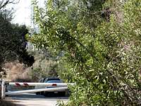 Sunset Ridge Trailhead
Walk to and past the fire road gate and you are on your way.
Route Description
From the fire road gate at the trailhead, begin hiking up the Sunset Ridge-Mt. Lowe Fire Road. Within 100 yards you will pass the point where the Altadena Crest Trail crosses the fire road. About 400 yards further along the fire road, you will come to the start of the Sunset Ridge Trail off to your left. The start is marked by a sign. Beginning of Sunset Ridge Trail
 Looking up Millard Canyon from the Sunset Ridge Trail
About ½ mile from the start of the trail, you will come to a junction. To your left is a bridge crossing over to the creek that winds down the canyon. A popular destination following the creek upstream is Dawn Mine, where gold was once mined. The Sunset Ridge Trail, however, continues to the right (it is marked by a sign here as well), but now the trail begins to climb out of the canyon. In about 1 mile of ascent, you will arrive at Sierra Saddle/Sierra Camp.
 Looking north from Sierra Saddle along Sunset Ridge Trail
Continue ascending from Sierra Saddle. Millard Canyon is a constant companion on your left.
The Sunset Ridge trail ends 2.5 miles from its start by connecting once again with the fire road. At this point, go left on the fire road and in about 100 yards you will come to the beginning of the Echo Mountain Trail. This ½ mile trail traverses between Sunset ridge and the summit of Echo Mountain.
 Start of Echo Mountain Trail off fire road
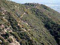 Echo Mountain (right) seen from Sunset ridge
Red Tape
You will need an Adventure Pass or Golden Eagle Pass to park your vehicle at the Sunset Ridge trailhead. There have only been rare occasions when Adventure Passes ($5 per day or $30 for a yearly pass) were sold at this trailhead. It is best to purchase one beforehand. They are sold at most sporting goods stores in southern California.No permit is required to hike the route described here.
Essential Gear
None. These trails can be hiked in trail runners.Other Information
This route can be hiked year round. Because of their low elevation, the trails comprising this route normally do not get snow, even in winter. There is water available from the creek where the Sunset Ridge Trail nearly meets the creek by the bridge mentioned above. However, the water should be treated.The Sunset Ridge trailhead is accessible year round. However, be advised that access by vehicle to Chaney Trail Drive leading to the trailhead is only allowed, according to a warning sign, between the hours of 6 a.m. and 10 p.m. daily.
USGS Topos Pasadena 7.5