SURPRISE IN THE WILDERNESS: AN ALPINE LAKES TALE
Prologue
It was Monday, September 8, 2008. I did not have to work. The weather forecast was great; mostly sunny skies and temperatures in the 70s. It seemed like a perfect scenario for an alpine hike.
I wanted to attempt a mountain hike within the
Alpine Lakes Wilderness. I decided to hike to the summit of
Surprise Mountain, in the Central Cascades south of Stevens Pass. I had never previously been to Surprise Mountain, but I heard its views and nearby Deception Lakes are spectacular to see. I decided to take my hunting knife/ hatchet interchangeable tool with me. Years ago, my grandfather had given me this tool but I had rarely taken it with me on hiking trip. However, going solo into the heart of the Alpine Lakes Wilderness, I did not want to take any chances. I would be going to a remote part of the wilderness area, and my normal potential hiking partners were unavailable. If I were to be attacked by an animal or another person, or if an accident happened, the knife/ hatchet tool would at least provide me with a fighting chance of success.
Creek Crossings and Forest Delights
I decided to take the route of least hiking distance from my vehicle. This route originates at
Fisher Creek Trail #1059.1, located off Forest Road #6830 southeast of Skykomish, Washington. Considering that my last two early morning hikes in the mountains were foggy, ruining many potential views, I chose to begin this hiking trip later than the crack of dawn. However, I had all day to enjoy the hike so I planned to maintain a leisurely pace to allow for various photos and breaks. I found a decent hiking stick at the Fisher Creek trailhead and began my hike at 8:30 AM.
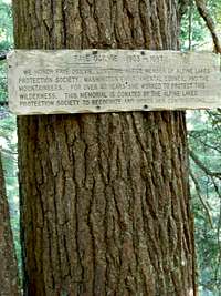
![Alpine Lakes Memorial Sign]() Memorial Sign
Memorial Sign
Fisher Creek Trail #1059.1 was uneventful. Besides watching and listening to birds chirping, the only thing worth noting on this 0.7-mile trail was a wooden sign nailed to a tree that I passed midway through. The sign commemorated Faye Ogilvie, a longtime member of the Alpine Lakes Protection Society. I arrived at the junction for Deception Creek Trail #1059 at 8:40 AM. I headed south.
![Deception Creek]() Deception Creek
Deception Creek
Approximately one minute later, I arrived at Fisher Creek and crossed it using several logs jammed at the intersection of the stream with Deception Creek. Several minutes later, the trail split at a “Y” intersection. A sign on a tree informed me the leftside path led to a direct crossing of Deception Creek (i.e. rock hopping and/or get wet), and the rightside path led to a footlog crossing over the creek. I first walked down to the creek but the water depth made rock hopping an impossible task. I turned around and took the other path. I crossed over a large footlog overhanging Deception Creek. When I arrived at the other side of the creek and rejoined the true trail, I realized the footlog did not add much distance, if any, to the route.
The rest of Deception Trail #1059 was a hike through an old-growth and second-growth Douglas fir forest. I admired the shelf fungi on various trees, as well as the size of some of those trees. This stretch of trail crosses several small streams at various locations. The final stream this trail traverses is split into two parts, causing the need for a double stream crossing. This occurs approximately 0.2 miles before the next trail junction. I arrived at the junction for Deception Lakes Trail #1059.2 at 9:35 AM. I took a 10-minute break.
No Deception at the Lakes
![Frog Along Deception Lakes Trail]() Frog Along Trail
Frog Along Trail
At 10:00 AM I passed through an outcropping of small boulders. A tiny frog hopped across my path as I walked by the rocky terrain. I was able to take some photos of the frog when he finally rested on a mossy rock. This stretch of terrain switchbacks up a densely forested slope. I arrived at the junction for Deception Lakes Trail #1059.A, which is actually a 0.4-mile portion of the Pacific Crest Trail, at 10:15 AM. Within a few minutes, I passed through a large boulder field and crossed over a small wooden bridge. The bridge crossed over a small stream originating from Deception Lakes, only a few more turns away.
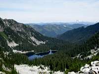
I arrived at the southernmost of the Deception Lakes at 10:20 AM, then proceeded to the next lake before taking a break for water and photos. The lakes are gorgeous. The surrounding scenery of evergreen forests, boulder walls, and alpine peaks is breathtaking. The water is green-colored, yet transparent enough to see the lake bottom. Even with the cold temperature of the water, it looked almost inviting enough to swim in. While taking the break at a rock outcropping next to one of the lakes, I heard a noise coming up the trail. The noise turned out to be a hiker traveling the Pacific Crest Trail from Mexico to Canada. We spoke for a few minutes. He left several months prior, on May 20. I really admire such personal ambition. It sounded like he has many stories to tell from the experience.
![Me At Deception Lakes]() At Deception Lakes
At Deception Lakes
At 10:45 AM I began following a path across the marshy north side of the largest lake. Tiny frogs were EVERYWHERE. I reached a small hill on the other side of the marsh, where the trail appeared to continue but became fainter. I followed the trail a bit further around the lake hoping for better locations to take photos. When I did not find any better photo-taking locations, I decided to turn around and continue my original quest. Surprise Mountain was looming over the Deception Lakes. My goal was within reach.
A Gap Between Surprises
At 11:10 AM I arrived back at a trail marker sign showing the direction of a “Horse Camp”. Looking at my GPS and map, this appeared to be the correct trail (Surprise Mountain Trail #1063) leading to the summit of Surprise Mountain. The trail begins by traversing along a forested slope before eventually opening into a steep meadow slope. I arrived at Surprise Gap, the top of that meadow slope, at 11:50 AM.
![Gully At Surprise Mountain]() View From Surprise Gap
View From Surprise Gap
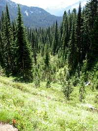
Surprise Gap is a small saddle connecting Surprise Mountain to an unnamed peak. The north views from this point are great. Glacier Lake, Surprise Mountain, Spark Plug Mountain, and even far-away Glacier Peak are visible from this point. Multiple trails lead from Surprise Gap. One trail leads east, up the unnamed peak. I considered possibly taking this trail later, after reaching my main goal of summiting Surprise Mountain. Another trail leads north, down a gully towards Glacier Lake. And another trail, the one I needed to take, leads up the southeastern slope of Surprise Mountain.
This stretch of trail begins by steeply climbing the upper southeastern slope of the peak, and then traverses horizontally across a sub-alpine meadow before steeply climbing north to the summit. During the walk across the sub-alpine meadow, I began to see views of a high snow-covered ridgeline to the west, located between Mount Daniel and Terrace Mountain. As I continued my hike up the final slope to the summit, I could also begin to see Marmot Lake between that ridgeline and Terrace Mountain. Being able to see an alpine lake from such a long distance (on another mountain across a wide valley) showed me how large the lake must be and how high in elevation I must be in relation to it.
![Me At Surprise Mountain Summit]() At Surprise Mountain Summit
At Surprise Mountain Summit
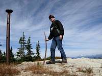
I arrived at the summit at 12:20 PM. I took a long break for food, water, and photos. What I previously heard WAS correct; the views from the summit ARE spectacular. In addition to the views seen from Surprise Gap I was able to see far to the north and west. Surprise Lake, located near Glacier Lake, also is not visible at Surprise Gap but is visible at the summit. The views of the western face of
Thunder Mountain are awesome, northeast of the summit, as well. There is a tall pole at the summit, the lone remnant from a past lookout location. A trail continues down the northwest side of the summit, but I chose not to follow it. I departed the summit at 12:45 PM, arriving back at Surprise Gap at 1:10 PM.
The Biggest Surprise Of All
Realizing I had not taken any photos taken of me at Surprise Gap during my ascent, I decided to take a short break to do so during my descent. I set my camera down on a small boulder and took a couple of photos. As I got ready to leave Surprise Gap, I looked at two immediate options. I could attempt to either follow the trail up the unnamed peak or return to Deception Lakes. Little did I realize at that moment the option would be decided for me. When I got my camera back in its camera bag I suddenly got a strange feeling. It was almost as if something bad was about to happen or I was being watched.
Thinking I might have heard something, and trusting my instincts, I loudly tapped my hiking stick against a small boulder several times. Suddenly a large cougar leapt out from behind some bushes nearly 20 feet from me, between my two trail options but closer to the trail leading to the unnamed peak. Startled by the noise, the cougar darted up that trail as I proceeded to loudly bang my hiking stick against a rock and small tree using my left hand. While doing this, I simultaneously grabbed my emergency whistle with my right hand, blew three loud long high-pitch tweets, and quickly reached for my hunting knife.
![Me At Surprise Gap]() Last Photo Taken Before Cougar Incident
Last Photo Taken Before Cougar Incident
It all happened so fast. The cougar ran away so quickly. It was unbelievable. There was no mistaking the massive size of the body (I estimate 7-8 feet long and 130-150 lbs) or the beautiful long tail with the black tip. I recall immediately thinking the nickname “puma” for the animal, because that was the sound made as his large paws quickly ran up the trail (puma… puma… puma). I realized the slim odds of encountering a cougar. Cougars are typically isolated and have wide home territories of 50-350 square miles. But I also realized what the cougar was probably doing... waiting patiently for me to pass the undetected animal before pouncing me from behind. No matter which of the trail options I would have chosen, the cougar had been in position to ambush me. I know what the cougar was probably doing... stalking me.
![Meadow Gully At Surprise Mountain]() South Slope of Surprise Gap
South Slope of Surprise Gap
Perhaps needless to say, I did not follow the cougar up the unnamed peak trail or take any more photos at Surprise Gap. I wish I had a photo of the animal, but I am more than satisfied with surviving the experience. I switched my tool from hunting knife to hatchet, for added mobility if needed. Then I proceeded down the southern slope of Surprise Gap. My pace was calm but moderate (so as not to give the cougar a fun target to chase, if he were to return), turning around every so often (because cougars typically do not attack if faced). I arrived back at the Deception Lakes by 1:30 PM.
Knowing a cougar can travel across terrain much quicker than a human can, as well as having a better sense of smell and hearing, I did not waste much time during my descent. I arrived back at Deception Creek Trail #1059 at 2:05 PM. Considering the incident that occurred less than an hour before, the surrounding dense forest raised my alertness even more than normal. I held the hatchet in my right hand the entire return-journey to my car. I finally arrived back at the Fisher Creek trailhead at 3:25 PM.
Epilogue
Despite everything, I am glad I did this hike and had this experience. I know to trust my instincts. I know I am fortunate to have the opportunity to tell this story. Most people will never see a cougar in the wild, much less stalked by one.
For at least this day, I definitely experienced more than one “Surprise in the Wilderness”.
Trip Data and Timeline
Monday, September 8, 2008:
TRIP DATA
TOTAL ASCENT TIME, INCLUDING STOPS: 3 Hours 50 Minutes
TOTAL DESCENT TIME, INCLUDING STOPS: 2 Hours 40 Minutes
TOTAL TRIP TIME, INCLUDING STOPS: 6 Hours 30 Minutes
HIGHEST POINT REACHED: 6330' (Summit of Surprise Mountain)
LOWEST POINT REACHED: 3200' (Junction of Fisher Creek and Deception Creek)
TRIP TIMELINE
8:30 AM: Began hike at trailhead for Fisher Creek Trail #1059.1.
8:40 AM: Arrived at Deception Creek Trail #1059.
8:45 AM: Arrived at “Ford/ Footlog” Sign.
9:30 AM: Arrived at split-stream crossing, along Deception Creek Trail #1059.
9:35 AM: Arrived at Deception Lakes Trail #1059.2. 10-Minute Break.
10:00 AM: Passed by small boulder outcropping. Encountered tiny frog.
10:15 AM: Arrived at Deception Lakes Trail #1059.A/ PCT #2000.
10:20 AM: Arrived at southernmost of Deception Lakes. 20-Minute Break. Met with PCT Traveler.
10:45 AM: Began hiking across marshy north embankment of Deception Lakes. Explored north side of lake.
11:10 AM: Arrived back at “Horse Camp” sign.
11:50 AM: Arrived at Surprise Gap.
12:20 PM: Arrived at summit of Surprise Mountain. 25-Minute Break.
12:45 PM: Departed summit.
1:10 PM: Arrived back at Surprise Gap.
Cougar incident.
1:30 PM: Arrived back at Deception Lakes.
2:05 PM: Arrived back at Deception Creek Trail #1059.
2:10 PM: Arrived back at split-stream crossing, along Deception Creek Trail #1059.
3:25 PM: Arrived back at trailhead/ car.
Comments
No comments posted yet.