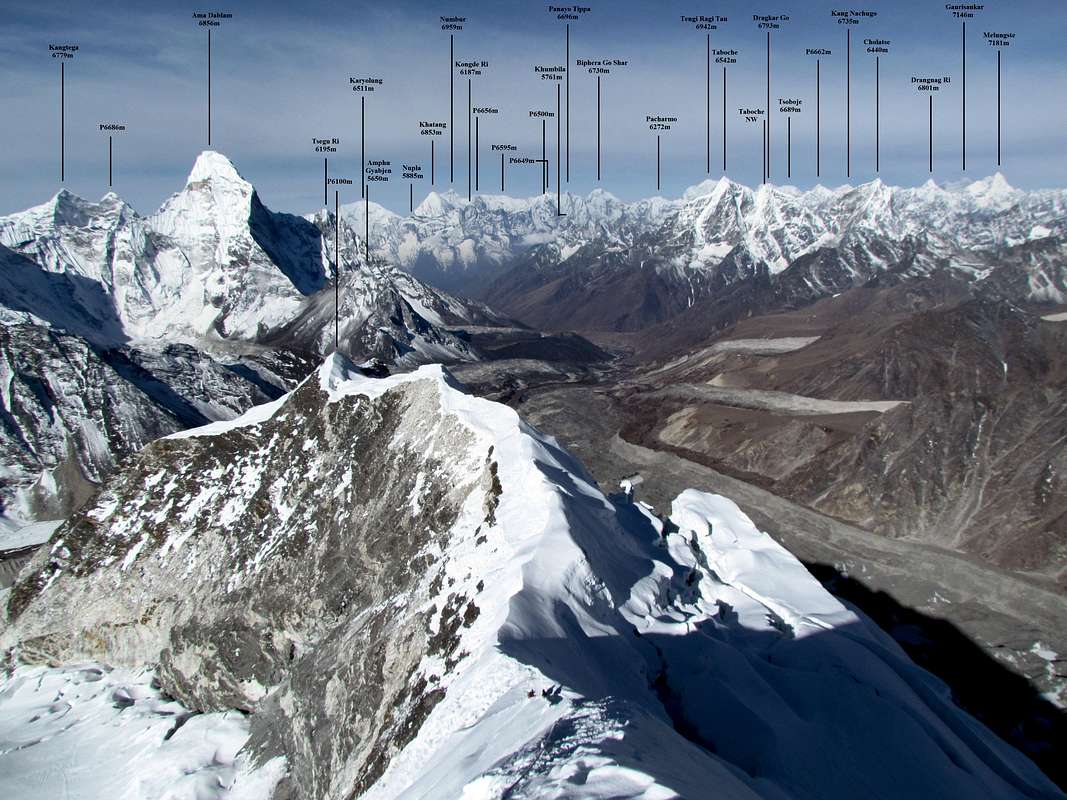


PAROFES - Oct 20, 2011 6:29 am - Voted 10/10
GreatWork Bruno, to label all that peaks probably was a hard job...

Bruno - Oct 20, 2011 9:18 pm - Hasn't voted
Re: GreatThanks. Definitely a harder and longer job to label the peaks than to climb Imja Tse... :)

Tomek Lodowy - Oct 20, 2011 9:44 am - Voted 10/10
superb jobI fully agree, great view and great job done here. Well done!
cheers,
Tomek Lodowy
Bruno - Oct 20, 2011 9:19 pm - Hasn't voted
Re: superb jobThanks Tomek!

lsheen - Oct 20, 2011 11:52 am - Voted 10/10
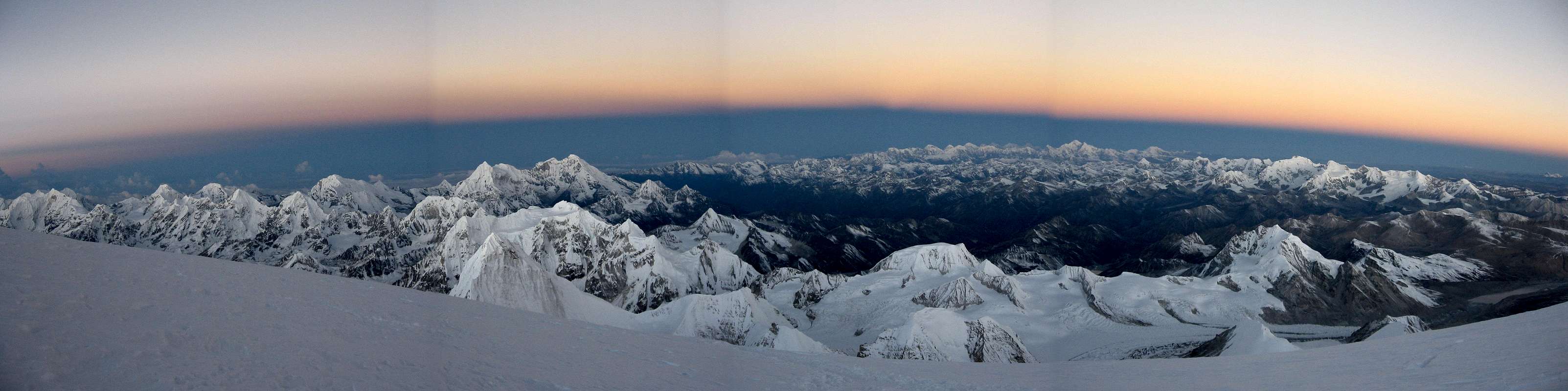
Outstanding shot, Bruno!Both the photo and the hard work that went into labeling all the peaks. Personally, I really enjoy info on the background peaks - especially the Himalayan giants from unusual vantage points.
I'm still working on labeling as many of the background peaks in this shot here as I can. I have many labeled that I am confidant of, but not as many as I'd like.
What tools and sources did you use to identify the background peaks?
Big Lew
Bruno - Oct 20, 2011 9:26 pm - Hasn't voted
Re: Outstanding shot, Bruno!Thanks! As primary tool, I use Google Earth (GE). I've tried to save as many summits as possible on GE through different methods, such as downloading kml/kmz mountain lists from Internet (but be careful, quite a lot of summits are wrong or just approximate), copying points from maps, and more in-depth research in the specialised literature, sometimes I found mountain lists with latitude/longitude in pdf/xls format, and changed them to kml. Then you need to know the exact point where the picture was taken, and you can start trying to identify the peaks by comparing with GE, using the same perspective. That's quite time-consuming.
For the panorama in Nepal, there are quite good maps existing (Schneider, Finn, Washburn, etc., I only have the first one), but altitudes and names may vary quite a lot. I try as much as possible to use the name/altitude used by the Himalayan Database (available on CD), which is usually the Finn map (unfortunately I couldn't find the Finn map...). This website also has an incredible collection of panorama, data are quite reliable even though I found a couple of mistake (mine probably have some too...).
For the panorama in Tibet or at the border with Bhutan, I don't have any good map (except for the Noijin Kangsang area) and the Himalayan Database only lists the summits in Nepal or on the border. The best source of information are the tables you can download at 8000ers.com . The creator of this site sometimes has more detailed excel tables that you cannot find on his website, including peaks with lower prominence. viewfinderpanorama.org also has a list of digital panoramas that can be quite useful. In some cases, for unnamed peaks with low prominence, the information can be from my own GPS readings or from GE. If it is GE, I will always write "P. approx. xxxxm", as the altitude in GE can typically be 10-50m off. If there is no "approx." mentioned, then it means the altitude is either from a map, from a GPS reading or from another reliable source.
To summarise, it is a mix of different methods, but always using GE to compare your picture with GE view. Using maps only can be quite difficult, especially for distant peaks.
Cheers, B.
Bruno - Oct 20, 2011 9:33 pm - Hasn't voted
Re: Outstanding shot, Bruno!Your picture is a very very good one from the upper slopes of Cho Oyu, looking towards Pasang Lhamu Chuli, Lunag Ri, Melungtse, Lapche Kang and Shishapangma, is this correct? :)
It is actually a quite difficult area for identification, as the naming may differ a lot, e.g. Pasang Lhamu Chuli has no less than four different names (also Nangpai Gosum I / Jasemba / Cho Aui) and the Lunag Ri massif has received a bunch of proposed new names recently for every little bump. The subpeaks of Lapche Kang do also have some conflict in the naming depending on the source. If you want, I can send you some GE points I have compiled for that area.
lsheen - Oct 20, 2011 11:29 pm - Voted 10/10
Re: Outstanding shot, Bruno!Thanks for all the info, Bruno. MUCH appreciated.
I just want to be clear, that's not my panorama/photograph. I have posted a request to the original poster asking for permission to label and repost, I have not heard anything back yet.
You are quite correct in your identification, Melungtse and Gauri Sankar are two of the easiest peaks to identify. Shisha Pangma is, of course, also prominent and easy to identify. The most challenging areas of this shot for me are the far left - which is the southern part of the Rolwaling Himal, and also center of the shot - the peaks of the Langtang Himal which is south of Shisha. I believe I have Langtang Lirung (RIP Tomaz Humar) correctly identified, as well as some of the satellite peaks of Shisha, but I'd like to have more peaks identified before posting.
I am using Google Earth (GE), and the excellent website you linked: www.Himalaya-Info.org, and then just searching on the web. Very few of the peaks I'm interested in are labelled in GE, and as you mentioned I have found some mistakes as well. I have half thought I might email Gunther Seyffert (the person who created Himalaya-Info.org) and ask for some assistance, but I have not done so yet.
No matter, I am fascinated by these huge peaks, and I really enjoy doing all the research.
As far as naming the peaks goes, I'm not too worried about that. I understand it's a moving target, that names change and some peaks are incorrectly identified, but that won't stop me from trying to quench my curiosity while enjoying myself!
Best regards,
Big Lew
seyfferth - Jul 22, 2015 9:25 am - Hasn't voted
PanoramaPlease open http://www.himalaya-info.org/island_peak.htm to see another phantastic Panorama with detailed captions. And please contact me if you find any mistake.
Best regards
Guenter Seyfferth
www.himalaya-info.org


Comments
Post a Comment