
-
 8118 Hits
-
 74.92% Score
-
 5 Votes
|
|
Route |
|---|---|
|
|
40.69220°N / 111.1971°W |
|
|
Hiking, Skiing |
|
|
Half a day |
|
|
Overview
 Upper reaches of Swifts Canyon
Swifts Canyon offers the best chance for solitude and quiet for non-motorized access to Hoyt Peak, and the most direct access to Northern slopes of North Hoyt for skiers in winter.
Getting There
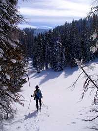
 Skiing past the Forest Service boundary
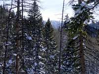 North Hoyt rises above East fork of Swifts
Take Weber River Road East of Oakley (you can shortcut by taking New Lane North if coming from Kamas). The road follows upstream on the North bank of the River and pulls into the mountains.
The first bridge is Pinon Canyon Road. Cross the bridge and take second left turn (at the base of the mountain slope) to a private cabins road. There is no public parking, but you can leave a passenger car in a little meadow before the last cabins, about quarter mile short of Swifts Creek. A higher-clearance vehicle can be driven for a half-mile more, to the FS boundary.
In winter Swifts Canyon turnoff is plowed nearly to the creek, but you may have to dig a parking spot in a snowbank. It is often easier to start at South Fork turnoff instead, which is the second bridge past Pinon junction. From there, cross the bridge and turn right at the first gate. Cross one more locked gate, descend towards the cabin area, turn left near a playground, and follow the road uphill into Swift Canyon.
Route Description
 Large meadows in Upper Swifts
 Not a real settler's cabin ... it is for a movie set
The jeep road continues for half mile past the FS boundary, to a wide meadow at a confluence with a large tributary from the East, and shortly after that ends at a little flat with the rustic cabins left from an old movie set.
From there, an ATV track continues steeply uphill East of the creek ravine, then levels off and eventually crosses the creek to a FS sign barring further motorized access. The summer trail continues on the West side of the creek, nearly fading at the open meadows in the upper bowl, then reemerging in the woods South of the meadows.
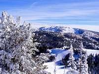 Summit View towards Duke Mountain
 Breaking trail near the summit of North Hoyt
In winter, both the main drainage and its East Fork are used to gain access to the open-woods slopes of the Hoyts.