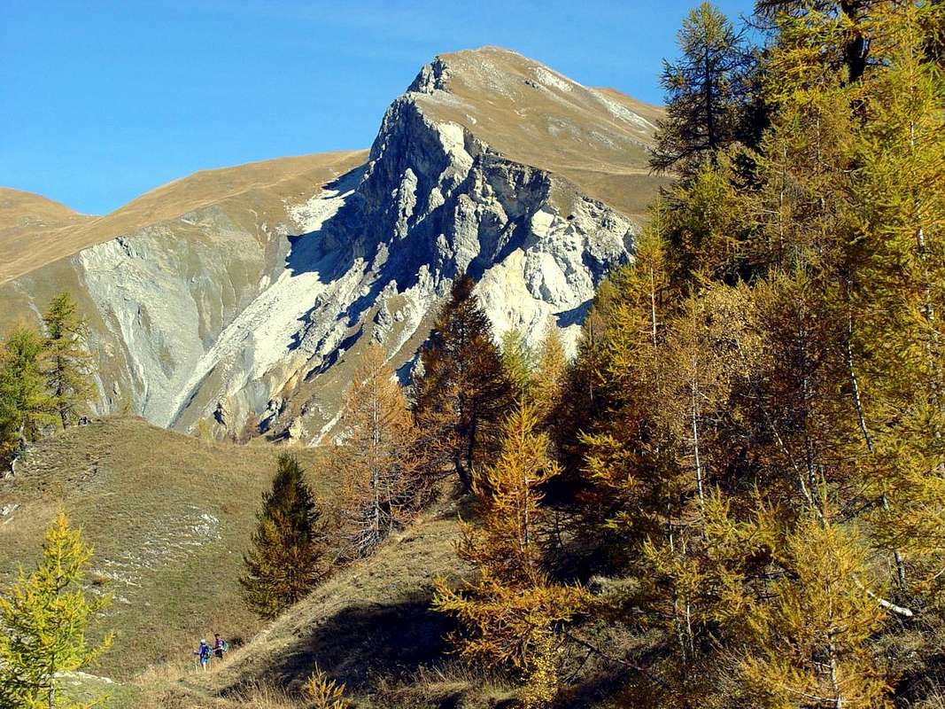
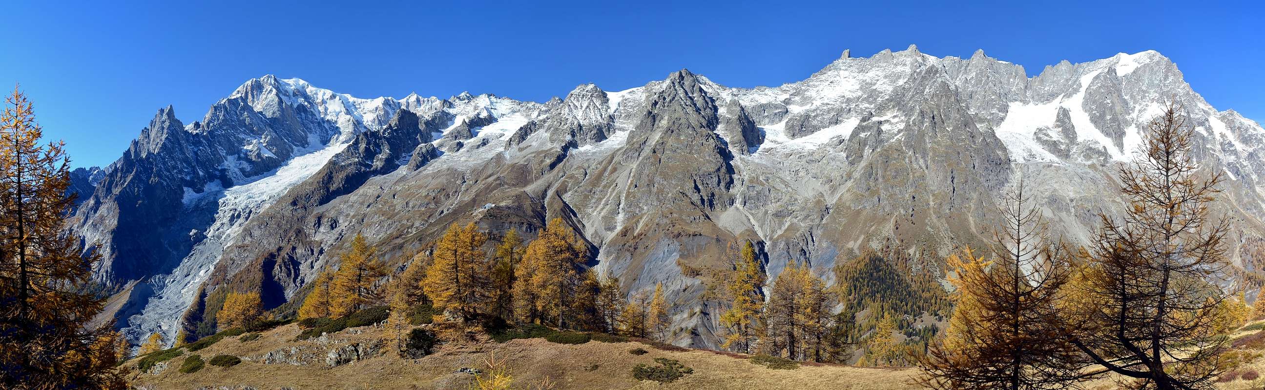
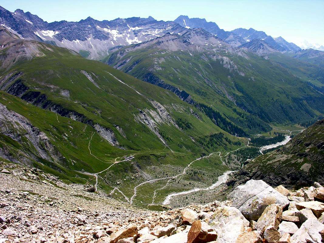
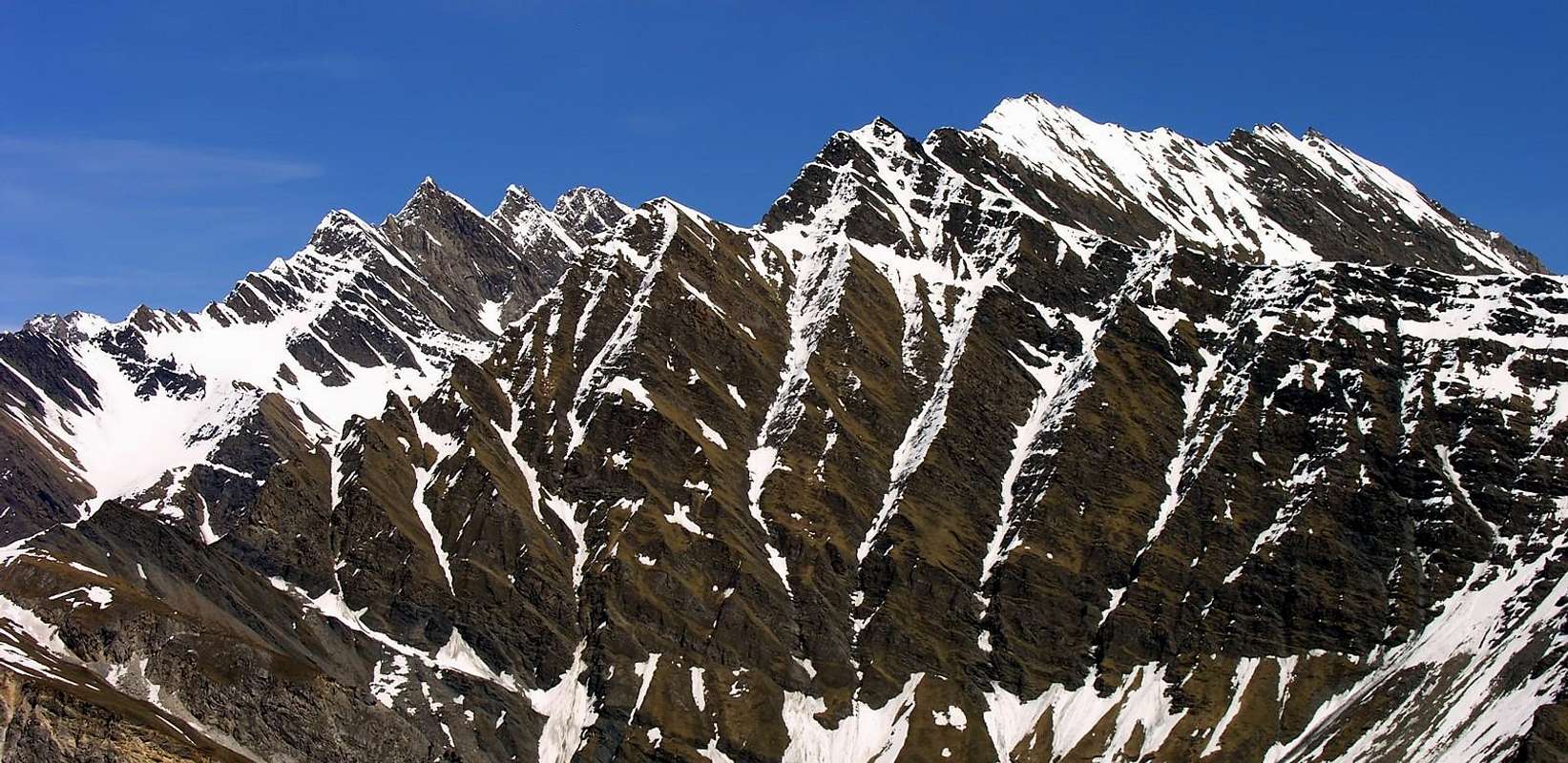
Even this Summit is part of the little Subgroup Grande Rochère (3.326m), although it actually belongs, as an extreme offshoot of the Southwest, the continuation of the divide that from Grand Golliaz (3.237m) down to the South by dividing the Val Ferret (West) by the Great Saint Bernard, Planaval and Sapin Valleys. This mountain, which is often visited for its ease, typically is achieved as the beginning of the easy passage that immediately below the Col Sapin (2.435m) in the small Sapin Valley in the South and that of Armina or Arminaz to the North, leads first to the neighboring Testa (Head) Bernarda (2.534m) and then to the various elevations of the Mont de la Saxe reaching its end Refuge Giorgio Bertone (1.991m). Splendid views over the entire mountain Chain of Mont Blanc and in particular, in front, on the Gr. Jorasses, showing their beautiful Ridges of Tronchey, Prà Sec and the Northeast famous as "des Hirondelles", while in the East it rises "imperious" the magnificent Grande Rochère highlighting its Ridges West-northwest and South.
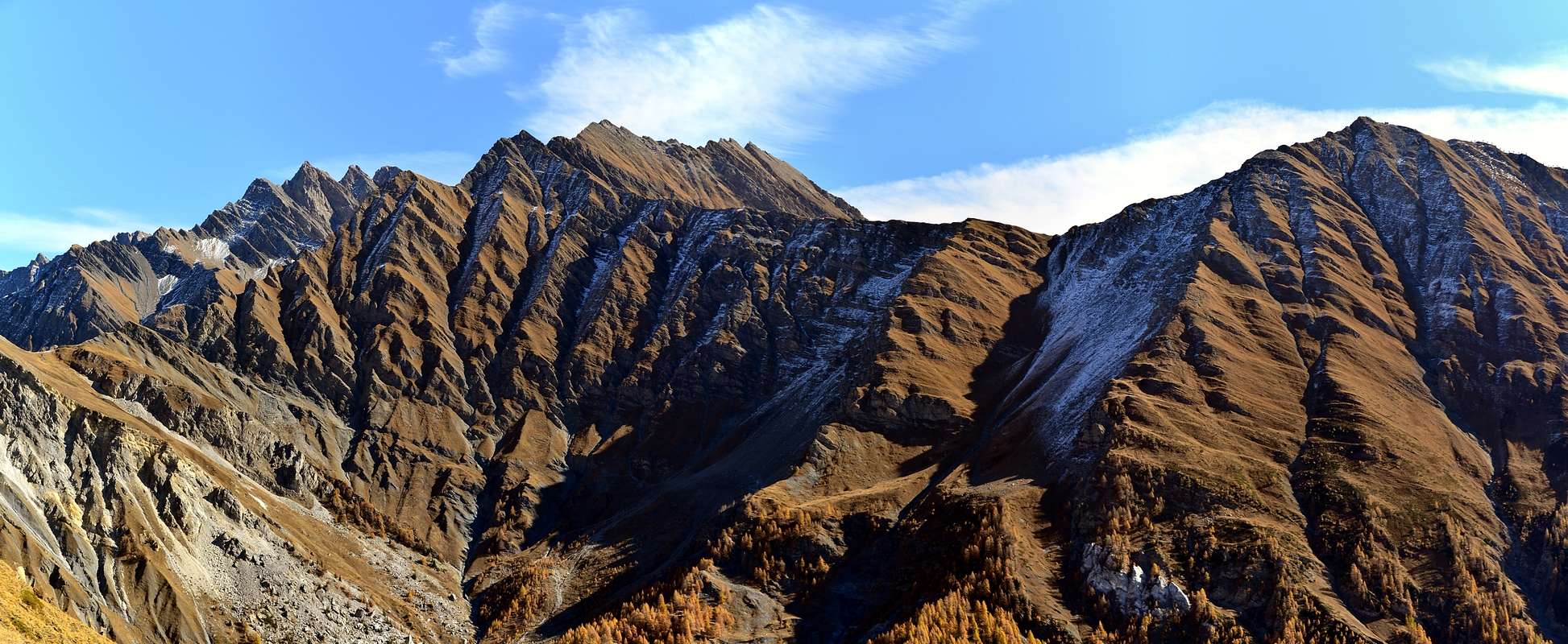
Small hatch Topographical: for greater precision is located at the junction of the rugged West Ridge-northwest of Grand Rochère, where it splits to altitude 3.134 meters by sending a branch shortest Northwest to the Tête de Sécheron (2.880m) and the Tête entre deux Sex (2.729m) with which it has an end. The second branch, much more extensive, addresses, always from the same altitude, first toward the Southwest over the Colle Battaglione Aosta (2.880m), the Aiguille de Chambave (3.067m) and the Tête du Curru (2.990m). Here takes an important and subsequent split with a watershed, descending South-southwest, dividing the small Vallon of Liconi or Licony, with its Hill, Lake and Tête (2.929m) from Val Sapin; the other goes completely counter to the Northwest to form the Col Sapin (2.435m), the Tête de la Tronche, the Testa Bernarda to Mont de la Saxe adapted to separate, as stated above, the Vallon of Armina in the medium-low Val Ferret by more Southern Val Sapin, impending the renowned "Villair" of Courmayeur.
Anche questa Cima fà parte del piccolo Sottogruppo della Grande Rochére (3.326 m), anche se in realtà appartiene, come estrema propaggine di Sudovest, alla continuazione dello spartiacque che dal Grand Golliaz 3.237 m), più a Settentrione, scende verso Mezzogiorno dividendo la Val Ferret (Ovest) da quelle del Gran San Bernardo, Planaval e Sapin. Questa montagna, abbastanza frequentata per la sua facilità in genere viene raggiunta come inizio della facile traversata che, subito appresso al Col Sapin (2.435 m) tra l'omonimo vallone a Mezzogiorno e quello di Armina o Arminaz a Settentrione, porta dapprima alla vicina Testa Bernarda (2.534 m) e poi alle varie elevazioni del Mont de la Saxe raggiungendo al suo termine il Rifugio Giorgio Bertone (1.991 m). Splendide vedute sull'intera Catena del Bianco ed in particolare, in fronte, sulle Gr. Jorasses, che mostrano le loro belle Creste di Tronchey, Prà Sec e "des Hirondelles", mentre ad Oriente si innalza "imperiosa" la Grande Rochère evidenziando le sue Creste Ovest-nordovest e Sud.
Piccolo tratteggio Topografico:per maggiore precisione é collocata sulla diramazione della frastagliata Cresta Ovest-nordovest della Grande Rochère, dove questa si sdoppia alla quota 3.134 metri inviando un ramo più breve a Nordovest verso la Tête de Sécheron (2.880 m) e la Tête entre deux Sex (2.729 m) con la quale ha termine sopra la Val Ferret. La seconda ramificazione, ben più estesa, si indirizza, sempre dalla stessa altitudine, dapprima verso Sudovest sopra il Colle Battaglione Aosta (2.880 m), l'Aiguille de Chambave (3.067 m) e la Tête du Curru (2.990 m). Qui avviene un importante e successivo sdoppiamento con uno spartiacque che, scendendo a Sud-sudovest, divide il piccolo Vallone di Liconi o Licony, con il suo Colle, Lago e Tête (2.929 m) dalla Val Sapin; l'altro si dirige in senso diametralmente opposto a Nordovest formando il Col Sapin (2.435 m), la Tête de la Tronche, la Testa Bernarda fino al Mont de la Saxe atto a separare, come detto, il Vallone di Armina nella medio-bassa Val Ferret dalla Val Sapin più a Mezzogiorno.
Getting There
BY CAR:
From TORINO, MILANO, etc: Motorway A5. Exit at IVREA or Quincinetto (PIEDMONT) From IVREA Town: in West to Pont Saint Martin, Donnas, Bard, Donnas, Saint Vincent, Chatillon, Nus, Quart, Aosta, Sarre, Saint Pierre, Villeneuve, Arvier, Avise, Morgex and to Pré Saint Didier, Courmayeur Municipalities. From Courmayeur Resort: in East to Pré Saint Didier and Morgex Municipalities.
From Courmayeur towards Val Ferret and Val Sapin From Courmayeur-la Palud(1.370m), towards Montitaz, Planpincieux (1.593m) Villages, Tronchey (1.620m), Praz Sec du Milieu, Lavachey (1.640m), Arnouva Dèsot (1.769m) Villages, through Municipal Road, to Malatrà Vallon and Walter Bonatti Refuge. Also from Arp Nouva to Elena Refuge, through dirt road on valley floor; or from the fork after Planpincieux, small bridge, towards Leuchey Dèsott, Damon Pastures to Mont de la Saxe Hump/Giorgio Bertone Refuge.
From Courmayeur-Villair Dessus(1.282m), with Municipal Road and through dirt road to fork 1.470 meters and path to Refuge Bertone in Val Sapin.
From FRANCE: through the Mont Blanc Tunnel to Entrèves-crossroads to Vény/Ferret Valleys - Mountain Guides of Courmayeur - La Saxe Rock Gym - Courmayeur. By Little Saint Bernard Pass, closed since November until half May to La Thuile Valley - Pré Saint Didier - Courmayeur. It is not necessary to take Motorway A5: you can drive on SS.26, in the direction of AOSTA - IVREA - TURIN.
BY PLANE:
Aeroporto "Corrado Gex" Saint Christophe (Aosta).
Approaches & Routes
Route A) - Approach from Courmayeur-Prà or Praz Sec: from Courmayeur-la Palud (1.370m) to subsequent parking (1.412m; in Northwest fork to Velà Chapy little Hamlet 1.467m, below Dent de Jetoula 3.306m); leaving left the last same, continue Northeast with Regional Road and towards Montitaz (1.550m), Planpincieux (1.593m) Hamlets, Tronchey-"Golf Club" (1.620m), alternative towards Praz Sec du Milieu and Damon (1.653m, below Southeast Face of Gr. Jorasses between the great Ridges Tronchey Pra Sec).
Via A) - from Praz Sec d'En Bas (1.624m): from the junction after the "Golf Club Tronchey" cross over a bridge the Doire de Ferret starting to rise to the East-southeast through the trail n° 29 that with close zigzag reaches a first unnamed alp (1.709m); the second (1.913m) becomes the same, bending more at Southeast, more linear and reaches the Alp of Arminaz (2.009m; E/F; 1h'00/1h'15), at the same name Torrent. From here continue with the same direction and on the shore hydrographic right (North) going up in parallel to the same until you reach the Tsa de Sécheron (2.260m; E F; 0h'45/1h'00), located between Pas d'Entre Deux Sauts (2.524m; to the North) and the Col Sapin (2.435m; in the southwest). Abandoned this path that directs the Hill Battalion Aosta (2.883m; in the Southeast), you continue to the Southwest through the path n° 42, reaching the crossroads 2.359 meters. From here two possibilities:
1) - continue through the same and in the southwest, skirting to the North the Tête de la Tronche, reaching the crest now to the Northwest of the watershed and with the corresponding short ridge and reach the Summit (2.584m; EE/F+; 1h'10/1h'20);
2) - from the junction with a little variation directly reach Col Sapin and go through the easy Ridge Southeast (E/F; 0h'50/1h'00). Logically, changing, you can go up and down with the other option.
Via A) - Avvicinamento da Courmayeur-Prà o Praz Sec: da Courmayeur in località la Palud (1.370 m) raggiungere il parcheggio successivo (1.412 m; quindi proseguire verso Nordovest insino al bivio per il Villaggetto di Velà Chapy 1.467 m, sotto la Dent de Jetoula 3.306m). Lasciando quest'ultimo sulla sinistra (Ovest), continuare con la Strada Regionale verso Nordest indirizzandosi progressivamente ai Villaggi di Montitaz (1.550 m), Planpincieux (1.593 m), il "Golf Club (1.620 m) nelle vicinanze del Villaggio di Tronchey, il successivo bivio verso i due Villaggi di Praz Sec du Milieu e Damon (1.653 m, sottostanti la Parete Sudest delle Grandes Jorasses tra le grandi Creste di Tronchey e di Pra Sec).
Via A) - da Praz Sec d'En Bas (1.624 m): dal bivio dopo il "Golf Club tronchey" attraversare su di un ponticello la Doire de Ferret iniziando a salire verso Est-sudest tramite il sentiero n° 29 che con stretti zig zag raggiunge una prima alpe innominata (1.709 m); dalla seconda (1.913 m) lo stesso diventa, piegando maggiormente a Sudest, più lineare e raggiunge l'Alpe di Arminaz (2.009 m; E/F; 1h'00/1h'15), presso lo omonimo Torrent. da qui continuare con la stessa direzione e sulla sponda idrografica di destra (Nord) salendo in parallelo al medesimo fino a raggiungere la Tsa de Sécheron (2.260 m; E/F; 0h'45/1h'00), sita tra il Pas entre Deux sauts (2524 m; a Nord) ed il Col Sapin (2.435 m; a Sudovest). Abbandonato questoche si indirizza al Colle Battaglione Aosta (2.883 m; a Sudest), si continua verso Sudovest per mezzo del sentiero n° 42, raggiungendo il bivio 2.359 metri. Da qui due possibilità:
1) - continuare tramite lo stesso a Sudovest e, aggirando a Settentrione la Tête de la Tronche, raggiungere la cresta spartiacque subito a Nordovest della medesima e con la corrispondente e breve cresta raggiungere la Sommità (2.584 m; EE/F+; 1h'10/1h'20);
2) - dal bivio con una piccola variante raggiungere direttamente il Col Sapin e salire tramite la facile Cresta Sudest (E/F; 0h'50/1h'00). Logicamente, variando, é possibile salire con una e scendere con l'altra delle due opzioni.
Route B) - Approach from Courmayeur-Villair: by Courmayeur Center neighbor the "Alpine Museum" (1.220m about), take the Municipal Road to the North in Val Sapin, in parallel towards East with this more important and wide of the Val Ferret, that reaches the eponymous hill where the end Graians and begin the Pennine Alps to which belong the Summits addressed in this Route (Tête de la Tronche and Testa Bernarda). Reached Villair-dessus where this ends for the use without its permission (1.382m; cartel ban immediately after the village); from this point start to climb towards the Northeast, through the same one that coincides with the path n° 38 until you reach the junction 1.470 meters which, through the n° 42/TMB to the West-northwest, reaches the Refuge Giorgio Bertone at the beginning along the watershed of the Mont de la Saxe. Abandoned this on the left, proceed on the valley floor always with the Northeast direction until you come to the next little Village of La Trappa (1.505m) and from this, exclusively through the same path to the equally tiny Village Tsapy (1.635m), very close the "Trou des Romains", where there is an ancient abandoned Roman Goldmine, (E/F; 1h'00/1h'15). Route from Tsapy or Chapy Hamlet (1.635m) towards Sapin Hill (2.435m): from the Village Tsapy, collocated at the center of the valley and at the end of the dirt road, leaving to the North the old route that runs along the valley floor along the Torrent de Tsapy then navigate to the Northeast to the hill, climb decidedly to the East via the trail n° 43/44, which quickly reaches the Freydevaz Pasture (1.739m). From here with sharp bends and semi circular path towards the Northeast to the fork 2.962 meters, just before the Torrent de Currù in the adjacent vallon. Discarded in South deviation, that by the trail n° 43A leads to Alp La Suche (1.810m), just after you reach the torrent. From this you leave on the right (East) the deviation with the trail n° 44 that leads to Liconi Lake, continuing, by means of a short descent, the path followed up to here which comes in a short time the Currù Alp; from here a long diagonal to the North, dominating from the high the vallon, easily leads to the hill by a long series of hairpins (E/F; 2h'15/2h'30). Variant by valley floor: Tsapy, where both the dirt road-path n° 38, ends, continue in the same direction, but with a smaller path and not numbered, going for a short time along the shore hydrographic right of the Sapin Torrent for then wade the same and continue on the other side until the altitude 1.732 meters, where you will return with a new ford to the West. This point the trail, always going up next to the same torrent, bends most at Northwest reaching the altitude of 2.164 meters, where it ends; reach through grassy slopes-detrital subsequent to 2.223 meters at two branches that give rise to the creek and, after crossing a small vallon toward Northeast, always using the same type of ground in a short time to reach the Sapin Hill (2.435m; EE/F; 1h'45/2h'15). Col Sapin (2.435m), left to right branch that goes down to the Tsa de Sécheron (2.260m) into the adjacent Arminaz Vallon, continue with the trail n° 42 in the Southeast Ridge of Tête de la Tronche to reach the same easily (2.584m; E/F; 1h'15/1h'30 from Sapin Hill).
Via B) - Avvicinamento da Courmayeur-Villair: dal Centro di Courmayeur, nei pressi del "Museo Alpino" (circa 1.220 m), prendere la Strada Municipale che s'indirizza a Nord verso la Val Sapin, parallela ad Oriente della più importante ed estesa Val Ferret, che raggiunge l'omonimo colle dove terminano le Alpi Graie ed iniziano quelle Pennine alle quali appartengono le Sommità trattate in questa Route. Raggiunto il Villair-dessus ove questa termina per l'uilizzo dei mezzi privi di relativo permesso (1.382 m; cartello di divieto subito dopo il villaggio); da questo punto iniziare a salire verso Nordest, tramite la stessa che coincide con il sentiero n° 38 fino a raggiungere il bivio 1.470 metri che, tramite il sentiero n° 42/TMB verso Ovest-nordovest, perviene al Rifugio Giorgio Bertone all'inizio del lungo spartiacque del Mont de la Saxe. Abbandonato questo sulla sinistra, procedere invece sul fondovalle sempre con direzione Nordest sino a pervenire al successivo Villaggio di La Trappa(e) (1.505 m) e da questo, esclusivamente con lo stesso sentiero al minuscolo Villaggio di Tsapy (1.635 m), nelle vicinanze del "Trou des Romains", ove esiste un'antica Miniera d'oro romana, ormai abbandonata (E/F; 1h'00/1h'15). Via dal Villaggio di Tsapy verso il Col Sapin: da Tsapy (1.635 m) al termine della poderale, lasciata a sinistra la vecchia via percorrente il fondo del vallone lungo il Torrent de Tsapy per poi traversare verso Nordest al colle, salire invece decisamente ad Est tramite il sentiero n° 43/44, che in breve tempo raggiunge l'Alpe di Freydevaz (1.739 m). Da qui con stretti tornanti e percorso semicircolare a Nordest si raggiunge il bivio 2.962 metri, poco prima del Torrent de Currù nell'adiacente vallone. Scartata a Sud la deviazione, che tramite il sentiero n° 43A conduce all'Alpe La Suche, subito dopo si raggiunge il torrente. Da questo si abbandona sulla destra (Est) la deviazione che con il sentiero n° 44 porta al Lago Liconi (2555 m), proseguendo, per mezzo d'una corta discesa, col sentiero sin qui seguito, che arriva in breve tempo all'Alpe del Currù (1.964 m); da questo punto un lungo diagonale a settentrione, dominando dall'alto il vallone, conduce facilmente al colle per mezzo di una numerosa serie di stretti tornantini (2.435 m; E/F; 2h'15/2h'30). Variante sul fondovalle: da Tsapy, al termine della poderale e del concomitante sentiero n° 38, si prosegue sempre nella stessa direzione, ma con un sentiero non numerato, salendo per breve tempo lungo la sponda idrografica destra del Torrent de Sapin per poi guadare lo stesso e proseguire sull'opposta fino alla quota di 1.732 metri, ove si ritorna con nuovo guado ad Ovest. Da questo punto il sentiero, salendo sempre affianco al torrente, flette più a Nordovest raggiungendo l'altitudine di 2.164 metri, dove termina. arrivare per mezzo di pendii erboso-detritici alla successiva di 2.223 metri presso due rami originanti il torrente e, dopo aver attraversato verso Nordest un valloncello, sempre tramite stesso tipo di terreno, in breve raggiungere il Col Sapin (2.435 m; EE/F; 1h'45/2h'15). Dal Col Sapin (2.435 m), lasciata a destra la diramazione che scende alla Alpe di Sécheron, continuare col sentiero n° 42 sotto la Cresta Sudest della Tête de la Tronche (2.584 m) raggiungendola facilmente (2.584 m; E/F; 1h'15/1h'30 dal Col Sapin).
Difficulty & Equipment
This route can be considered E/F or EE/F+ (Experts Hikers) in winter (even by snowshoes or Ski).
L'itinerario è da classificare in E/F oppure EE/F+ (Escursionisti Esperti) in inverno (anche tramite Racchette da neve od in Scialpinismo).
Hiking gear, in winter as for Ski-Mountaineering or with Snowshoes.
Da Escursionismo, in inverno da Scialpinismo o con Racchette da neve.
Mountain Conditions
You can get meteo information at the official site of the Regione Valle d'Aosta:


 5898 Hits
 86.85% Score
 23 Votes