
|
|
Mountain/Rock |
|---|---|
|
|
41.44644°N / 115.0099°W |
|
|
Elko |
|
|
Hiking |
|
|
Spring, Summer, Fall |
|
|
8846 ft / 2696 m |
|
|
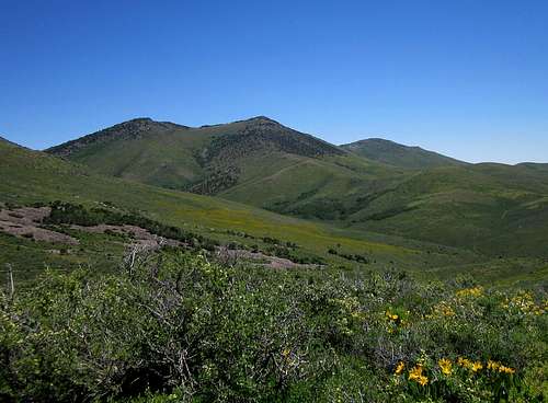
Tabor BM (center)
Overview
Chasing prominence peaks in the state of Nevada will take you to places that few people visit and are even aware of. Often times, you get a real sense of adventure by being involved with the need to drive miles and miles of dirt roads and the need to utilize vehicles that have high clearance and four wheel drive. You need to be self reliant and have a vehicle that is in good shape and make certain that you have plenty of gas, water and supplies since you often end up a long way from anywhere. In rainy weather, many of the Nevada backroads become impassable (think mud) and so you need to keep an eye on the weather. Fortunately, this peak isn't all that far off of a major interstate and so access to get close isn't a huge problem. A nearby campground also means that there is a chance there might be others in the area.This unknown gem is found in the Snake range north of Wells Nevada. As is often the case in this part of Nevada, summit visitors are rare and the register on the summit testified to that fact. The highpoint of this range is known as Tabor Benchmark and with a prominence of 2518, it comes in as the 100th most prominent peak in Nevada.
Getting There
Taking I-80 to Wells, take the US 93 exit and take the first left on the north side of the interstate. This is 6th street, follow it into the old section of town to Lake Ave. When you get to Lake Ave, turn north and go across the tracks. Take a left (west) onto 8th street and stay on the north side of the tracks as they head west out of town and the road will transition from dirt/gravel to pavement. Follow the pavement as it heads first west and then goes north, eventually becoming a well graded dirt/gravel road again. It is roughly 30 miles to a turnoff for Tabor Creek campground. Go through the campground, crossing Tabor Creek twice before reaching a jeep road not far from campsite 12. We only saw one sign for Tabor Creek campground and that sign was 4 miles from the campground itself so be sure and do the mapwork necessary to know where you are at. It was valuable to us to have done so since we did much of the drive in the dark.Address: Bureau of Land Management
Elko District Office
3900 E. Idaho Street
Elko, NV 89801 Phone: 775/753-0200
 |  |  |
Red Tape
The route we utilized was not posted for no trespassing although some of the jeep road appears to pass through some private land. The route along with a map will be posted in the section below noted as "the route".Address: Bureau of Land Management
Elko District Office
3900 E. Idaho Street
Elko, NV 89801 Phone: 775/753-0200
 |  |  |
Camping
• Tabor Creek - 30 miles northwest of Wells on mostly gravel road. Elevation 6,000 feet, 10 campsites, tables, fire rings, toilet facilities, no drinking water, fee $2 accessible mid April - late November.Despite the fact that all the references I could find say there are only ten campsites, we found twelve in total. Two are past the stream crossings and are rarely occupied. You might have to share number 12 with cattle however so be aware of that. This campground has three different vault toilets placed in intervals since the campsites are along the road and widely spaced for the most part.
BLM Description: "Tabor Creek Recreation Area is 30 miles north of Wells on the west side of the Snake Mountains. There are 10 campsites with tables and fire rings, and vault toilets. Drinking water is not provided, however water out of Tabor Creek is clear and suitable for drinking if it is properly boiled or filter purified before use. No garbage service is provided; visitors are asked to follow the “Pack it in - Pack it out” outdoor ethics by taking out what you brought in, plus a little extra that you might find laying around. Tabor Creek offers good stream fishing for trout, and the nearby Snake Range is popular for mountain biking, hiking, and wildlife viewing. The use fee is $2 per vehicle per day."
Weather
Wells weather"the route"
After driving through the Tabor Creek campground, crossing the Tabor Creek twice, watch for a jeep road that takes off uphill to the right. (My odometer recorded it as 3.2 miles from the Campground / Fee area sign)This jeep road requires high clearance and 4WD so if you are driving a low clearance vehicle, you might need to hike up from the campground. From the junction where you get on this road, it was 1.6 miles to a gate. The jeep road will take you to within less than two miles from the peak and save you considerable elevation gain and loss. My odometer said it was 1.7 miles from the gate to where we parked.
The first notable landmark on the jeep road is a gate (mentioned above) that you will need to open and close at the 7430' mark. The road then drops downhill and then a stream crossing before heading back uphill to a saddle. At the saddle, a track is noticeable heading toward point 7122 and we were able to drive up to this point before parking and beginning our hike to the summit. A drop of about 100 feet will put you at another saddle and another jeep track that we walked up to its end at around 7800'. From there we just made our way up the ridge toward the summit. A talus field was encountered but there were no difficulties and nothing beyond class 2 hiking. The summit itself contains a central benchmark and a couple witness markers. A small glass container had a register in it. The views: Priceless.
Use this link for a map that you can use to visulize the terrain and the
waypoints noted below.
Note the key GPS waypoints on the map are in lat/long nad 27 datum.
Jeep road N 41.44591 W 115.07295
Gate N 41.44797 W 115.05325
Saddle N 41.44080 W 115.04037
7622 TH N 41.44218 W 115.03153
Summit N 41.44644 W 115.00990
Our totals were:
Roundtrip 3 miles (depends on how far you can drive)
Elevation gain - 1400'
 |  |  |
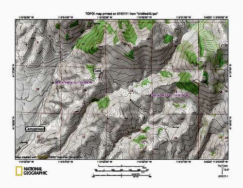
route map
The sumit register
It was surprising to me to find so few visitors to the top of this one.In the summit cairn, was a glass jar containing the register left by
Gordon MacLeod and Barbara Lilley. So far as of 2015, this is as up to date as I am aware:
1999 - Gordon MacLeod (Calif) and Barbara Lilley (Calif)
2003 - Tom Roundtree (Nevada)
2006 - John Vitz (Calif)
2011 - Dean Molen(Utah) and Ken Jones (Washington)
2012 - Mark Nichols (Arizona)
2014 - Dennis Poulin (Oregon)
2014 - Victor Zhou (Utah / Mass)
2014 - Brett Hathaway (Utah)
2014 - Bob Sumner (Nevada)
2015 - Andy Martin (Arizona)
2015 - Kelly and Terry Lister (Nevada)
You can see that this appeals to a lot of out of state peakbaggers.