
-
 10184 Hits
-
 82.48% Score
-
 15 Votes
|
|
Mountain/Rock |
|---|---|
|
|
39.07320°N / 105.3908°W |
|
|
Park |
|
|
Hiking |
|
|
Spring, Summer, Fall, Winter |
|
|
8954 ft / 2729 m |
|
|
Overview
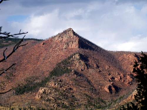 Pilot Peak from Tappan Mountain
Tappan Mountain is a low but extremely accessible peak in the Tarryall Mountains. The rounded mountain sits at the northern end of the Tappan Gulch, just a few miles south of the Lost Creek Wilderness. Pilot Peak rises bold and rugged, due-north of Tappan Mountain, bearing the scars of the total scorching it received during the Hayman Burn. Tappan Mountain is a small, mellow hill, but a pleasant place to get away from the crowds and sit quietly taking in the views and the listening to the whisper of the pines.
Large swaths of this petite peak were burned in the Hayman Fire, especially along the western slopes. From the summit of Tappan, one can look north and west at the destruction caused by this fire. The land is healing slowly from this large, hot blaze which burned nearly 140,000 acres in four counties. The cause of this fire was arson.
Colorado Rank: 2952nd highest peak in Colorado
Prominence: 547 feet
Mountain Range: Tarryall Mountains
USGS Quad: Tarryall
Trails Illustrated Map: Trails Illustrated #137 (Pikes Peak, Cañon City)
*Rank and Prominence Reference: Lists of John
Getting There
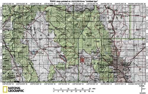 Click map image to enlarge.
Tappan Mountain sits one mile northeast as the crow flies off of Park County 77. The peak is located in eastern Park County about 6 miles north-northwest of the small community of Lake George.
Red Tape
 UN 8906 west of Tappan Mountain
 Pikes Peak from Tappan Mountain
Much of the National Forest access along the Tarryall Valley is characterized by public access easements through private property lining the road/creek. Be respectful of the property rights of the owners who grant us access through their property.
Otherwise, there is little red tape governing recreational use in this part of the National Forest and there is no fee to access this area. Adhere to LNT (Leave No Trace) principals, observe fire ban when in effect and do not harass wildlife or allow your pet to do so.
Camping & Lodging
 Southeast down the Tarryall Valley
 Tappan Mountain from the South
FS 244 and Immediate Surroundings
A few rustic camp sites can be found along FS 244 and spur roads off of it. These sites are available on a first-come first-served basis and are dry: No water, from a pump/well or other water body, is available, so pack water sufficient for your group size and the duration of your stay.
Designated National Forest Service Sites
The National Forest Service has a large selection of campgrounds in and around the Lake George area.
| Campground Name | Elevation | Sites | Nightly Rate | Reservations? | Notes |
|---|---|---|---|---|---|
| Blue Mountain | 8,200 ft. | 21 | $12 | Yes | Just a couple miles south of Lake George. |
| Spruce Grove | 8,600 ft. | 27 | $12 | No | Let the gurgling Tarryall Creek sing you to sleep. |
| Twin Eagles | 8,600 ft. | 9 | $8 | No | Must haul or purify drinking water. |
| Happy Meadows | 7,900 ft. | 8 | $12 | No | Situated along the South Platte River. |
| Round Mountain | 8,500 ft. | 16 | $12 | Yes | Drinking water, vault toilet and trash pickup. |
| Springer Gulch | 8,300 ft. | 15 | $12 | Yes | Situated within the Elevenmile Canyon; water, tables, fire grates. |
| Riverside | 8,000 ft. | 19 | $12 | Yes | Situated within Elevenmile Canyon; large grassy meadow with little shade. |
Cabins, Lodges and Hotels
Numerous cabins can be rented in and around Lake George. There are also a few cabins/lodges/dude-ranches along the Tarryall Creek catering especially to the fly fishing visitor. For example: Ute River Ranch
Weather & Seasons
 Frosty Ponderosa Pines
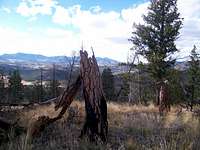 Hayman Burn Remnants
Summer: The route can be a bit hot and dusty in the summer, but the road should be dry and accessible and the breezes on top pleasant.
Spring: The snowpack is less deep here than in the high country and melts out faster than higher areas to the west. None-the-less, expect post-holing through unconsolidated snow drifts in the trees.
Fall: The aspen coating the slopes of this peak and surrounding neighbors make this area a golden-hued heaven in the fall.
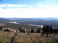
 Looking east from Tappan Mountain
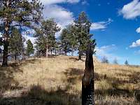 Approaching the summit of Tappan Mountain
Winter:
Thanks to proximity to Park County 77, this peak is accessible year-round, though deep snows/drifts and 4x4 road closures could add several miles to the roundtrip journey to the summit of this peak and back to your parking.