Little wall dominant and overlooking the Chamolè Lake (2.311m), included between the NE Crest (normal route) and NW Ridge and divided into two evident parts by an small rochy pillar. The N-NE, in left to Chamolè Pass (2.641m), Face is 200 meters high; the North Wall, in right, is 280/90 meters high. Nice excursion at the beginning of season (May-Jun) or to end (October-November). We'd better go by departure from Pila Village (1.000 meters difference in level). At the beginning of season training for crampons use and engagement in hard snowy slopes and in snowy rocks. Good views from left to Grivola Group, in entire Pila "Conca" or Basin in lower Chamolè Lake and in the whole Emilius Mountain Chain. In North towards Grand Combin and Pennine.
Piccola parete dominante il Lago di Chamolè (2.311 m), compresa tra le creste NE (via normale) e NW e separata nettamente in due parti da un pilastrino roccioso. La parete di sinistra o N-NE, verso il Colle di Chamolè (2.641 m), è alta 200 metri circa; il "muro" di destra o Nord è alto 280/90 metri circa. Buona gita di allenamento di inizio (Maggio-Giugno) e fine stagione (Ottobre-Novembre), meglio se con partenza da Pila, circa 1.000 metri di dislivello. In inizio stagione permette di calzare i ramponi impegnandosi su pendii di neve dura e rocce ancora coperte di neve. Belle viste da sinistra sulla Grivola, sulla Conca o Bacino di Pila, sul sottostante Lago di Chamolè nonchè sull'intero Gruppo dell'Emilius, mentre a Nord sulle Alpi Pennine con Grand Combin.
First ascents
N-NE Face (Left Sector): Amilcare Crétier and Lucine Salval, Summer (1925).
N Wall (Central Pillar): Osvaldo Cardellina and Dario Sergio Cardellina, (Jul 29th, 1966), in day from Pian Felina. *First Repetition: Osvaldo Cardellina, Fabio Roverso and Remigio Roverso, (Oct 09th, 1986).
N Wall (Direct Variant): Osvaldo Cardellina, solo (Sep 02th, 1988).
N Wall (Red Plates Route or Variant n° 2): Vincenzo Di Dato, Rossi and Savioz, (Nov 20th, 1977; not traced in the photo).
N Wall (Central Gully): Osvaldo Cardellina, lone (Jun 30th, 1968). * First Repetition: Osvaldo Cardellina and Riccardo Botti, (Aug 03th, 1969).
N Wall (Right Sector): Ilario Antonio Garzotto and Osvaldo Cardellina, (Sep 22th, 1967). * First Repetition: Ilario Antonio Garzotto, Mirko Zavanella, (Oct 06th, 1967).
N Wall (Extreme Right route) and NW Ridge: Osvaldo Cardellina, lone (Aug 31th, 2004; not traced in the photo).
Getting There
BY CAR:
From Torino, Milano, etc: Motorway A5. Exit at Aosta Est.
From Switzerland: through the Grand Saint Bernard Tunnel or the namesake Pass.
From France: through Mont Blanc Tunnel or Petit Saint Bernard Pass. It isn't necessary to take Motorway A5: you can drive on SS.26, in the direction of Aosta.
BY PLANE:
Aeroporto "Corrado Gex" Saint Christophe (Aosta).
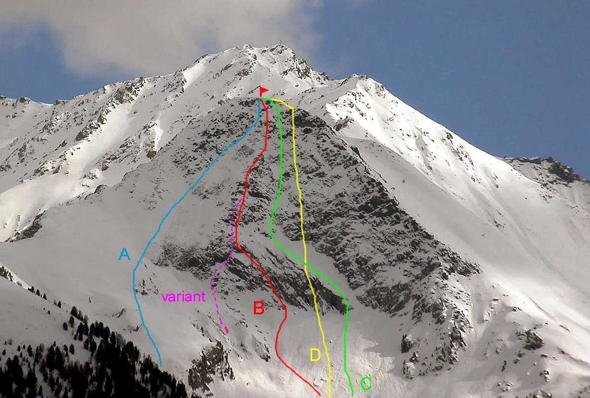
Route (A) Left Sector East
From Pila (famous ski resort easy and fastly reachable from Aosta using car, bus or cableway), get the Chamolé Lake (2.311m) on foot or by a chairlift. From Chamolè Lake go along the path to Chamolè Pass (2.641m) as far hairpin bend (2.485m). To change gear direction from SW to SE and to cross towards the little (200m) N-NE Face. To climb by little rocky slope, wihtgrass; then by more difficulty rocks in terminal part straight to Summit Cross (PD-; 1h'15 from Lake; 1h'30 from Station).
Da Pila (nota località sciistica, raggiungibile da Aosta in auto pullman o funivia), raggiungere il Lago di Chamolé (2.311 m, anche qui in seggiovia o a piedi). Dal Lago di Chamolè risalire lungo il sentiero che porta all'omonimo Colle (2.641 m) sino al tornante (2.485 m) ove cambia direzione da SW in SE e traversare in direzione della parete risalendo prima per pendio con roccette e erba, poi per rocce più impegnative (I°/II° nel finale) direttamente la paretina N-NE sino alla vetta (PD-; 1h'15 dal Lago 1h'30 dalla Stazione).
Route (B) Little Central Pillar with two Variants
To border with West shore the Chamolè Lake (source) and to go up stony ground to North Face (at the beginning of season, May/Jul, hard snowfields) and to reach the base in altitude 2.540m. By easy and little crossing in left (East) to climb a steep rocky and moving to te left on edge of the little pillar and to, integral climb, Summit (PD+; 1h'30/2h'00 from Chamolè Lake).
Costeggiare il Lago di Chamolè sulla sponda Ovest (sorgente) e risalire la pietraia in direzione della parete Nord (in inizio stagione Maggio/Giugno, nevati in neve dura) raggiungendola al centro a quota 2.540 m Con leggera traversata a sinistra (Est) risalire una fascia rocciosa ripida (II°/III°-) portandosi sul filo del pilastrino e risalirlo integralmente sino in vetta (PD+; 1h'30/2h'00 dal Lago di Chamolè).
VARIANT 1: From stony ground to climb in vertical to little pillar by rocky steps with lichen and red/orange mossy rocks (II°/III°+) and to joint with the route B (AD-; 2h'00/2h'30).
VARIANTE 1: Dalla pietraia portarsi direttamente sulla verticale del pilastrino e, superata una fascia rocciosa caratterizzata da licheni e muschi rosso/arancioni (II°/III°+), ricongiungersi all'itinerario B (AD-; 2h'00/2h'30).
VARIANT 2: no drawn and between purple and red in the picture. From stony ground to climb, again more directly, in vertical to little pillar and, overcoming a rocky bend characterized by steps with lichen and mossy rocks (more red than orange; II°/III°+/IV°-), to reach the previous route B (AD+; 2h'30/3h'00).
VARIANTE 2: non tracciata e tra viola e rosso nella foto. Dalla pietraia portarsi, ancora più direttamente, sulla verticale del pilastrino e, superata una fascia rocciosa caratterizzata da passaggi con licheni e muschi più rossi che arancioni (II°/III°+/IV°-), ricongiungersi al precedente itinerario B (AD+; 2h'30/3h'00).
Route (C) Central Gully
From stony ground to direct one steps in right (W) of the rocky band at base in altitude 2.530 meters. At the beginning to get over rocky "narrowing" by plate leaning to the left (E) and to reach a great and curve dress circle. To in left (in snowy possibility) until the entrace of the central gully and to reach (I°/II°+;35°/45°) and exit-out 20/30 meters in West of the Summit (PD-; 1h'30/2h'00).
Dalla pietraia indirizzarsi più a destra (W) sulla faccia rocciosa basale andando ad attaccare a quota 2.530 metri. Superare una "strozzatura" rocciosa per una placca inclinata verso (E) e raggiungere una grossa cengia ad arco che risale verso sinistra sino all'imbocco del canale centrale. Risalirlo (I°/II°+) sino ad uscire 20/30 metri ad W della vetta (PD-; 1h'30/2h'00).
Route (D1) West Sector outline left
To start between B and C and to overcome a succession of the steep plates, with black stains and climb right Side (West) of the Wall. Unfixed route; by good rocks amusing passages. To exit-out 30/35 meters in West of the Summit (AD+/PD+; 1h'30/2h'30).
Attaccare tra le vie B e C e superare una seria di placche ripide con macchie nere di umido (II°/III°+(IV°-) risalire il lato destro (Ovest) della parete che offre anche, senza percorso obbligato, dei passaggi su bella roccia (divertente). Uscire 30/35 metri ad Ovest della vetta (AD+/PD+; 1h'30/2h'30).
Route (D2) Central West Sector to Northwest Crest
Begin immediately to the right of the via on the Central Gully (beyond the green and further West; not drawn on the photo) and back flexing gradually, but only slightly, to the left (East) to overcome a series of stone small walls alternating with small ledges with gravel ( snowfields in early season). Reach the most in view in the double rocks before the Summit swerving to the right on the first 45 meters and continue for a short distance with Cresta Northwest until you reach the exit of the previous route that in the (AD+/PD+; 2h'00/2h'30). Via longest 70/80 meters compared to the previous route and slightly more difficult but with some necessary step up and down on the media. Funny output.
Iniziare subito a destra della via sul Canalone Centrale (oltre il colore verde e più ad Ovest; non tracciato sulla foto) e risalire flettendo progressivamente, ma di poco, verso sinistra (Est) per superare una serie di muretti alternati a cengette con ghiaia (in inizio di stagione nevai). Raggiungere le rocce più in vista appena prima della Sommità deviando verso destra sulla prima a 45 metri circa e proseguire per breve tratto con la Cresta Nordovest fino a raggiungere l'uscita del precedente itinerario con il quale in (AD+/PD+; 2h'00/2h'30). Via più lunga di 70/80 metri rispetto alla precedente ed appena più difficile ma con qualche passaggio obbligato nelle parti inferiore e media. Uscita divertente.
Parents refers to a larger category under which an object falls. For example, theAconcagua mountain page has the 'Aconcagua Group' and the 'Seven Summits' asparents and is a parent itself to many routes, photos, and Trip Reports.

 6353 Hits
 84.27% Score
 18 Votes