Foreword.
The first weekend of January was a big deal to me. Not only was it my first chance at refuge from the absurdity of the holidays, it was also one of few seemingly rare clusters of days that both Sarah and I had time to spend together. When a big storm blew in at the last minute and dumped close to a foot of snow on our originally planned routes in The Gores, we were forced to pick an alternate. Enter The A-Basin Traverse.
We didn't do any research prior to the traverse and all we had to go on were photos from Grizzly Peak and below Loveland Pass. A close friend of mine had done it several weeks prior and reported that "it was easy" and "I might be disappointed." Despite these claims, I distinctly remembered Black Mountain looking fairly technical during one of my past winter ascents of Grizzly Peak and decided to pack a half rope and light rack. Our gear included a 30m 8mm rope, camalots to .75, a set of stoppers, and 5 alpine draws.
A long walk on the Divide.
![Loveland Pass]() Loveland Pass
Loveland Pass
Hiking by 7:30 AM, we made short work of the slope to PT 12915. Here I made a decision that nearly cost us the traverse and definitely cost us some time on the ridge. I hadn't gotten Sniktau in my two previous trips to Grizzly Peak and wanted to make the quick detour. Sarah had already gotten it and wasn't interested. We parted ways and I dropped my pack to jog out to the summit and back. Unfortunately I slightly underestimated the time commitment involved, as I thought Sniktau was the first visible point on the ridge. Surprise! The false summit strikes again.
![Cupid Sunrise]() Cupid Sunrise
Cupid Sunrise![Ridge Neve]() Ridge Neve
Ridge Neve
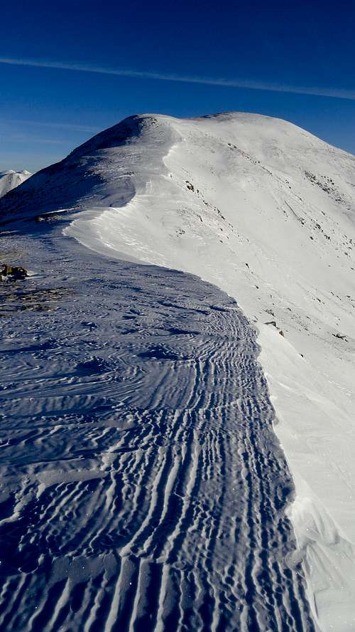
30 minutes later I was standing on Sniktau. I have to say that of all the ridge we walked that day, the ridge to Sniktau was by far the most beautiful and most pleasant to walk along. The ridge crest is smooth and rounded and harbors a wide strip of wind hammered neve that terminates along a near vertical cornice, a literal sidewalk in the sky. I snapped a few photos of the nearby summits, paying special attention to Pettingel Peak, The Citadel, and the eastern Gores.
![Cornice Walk]() Cornice Walk
Cornice Walk![Vertical Cornice]() Vertical Cornice
Vertical Cornice
Before long I started to feel the clock ticking and knew that I needed to get moving if I was to catch up with Sarah. I blazed back up the ridge to my pack in 20 minutes and started up (and down) the ridge to Grizzly Peak. Along the way I caught a few glimpses of Sarah weaving in and out of the talus and did my best to close the gap. By 11:30 we had reunited on the summit of Grizzly Peak and we had our first good views of Black Mountain and the ridge to Lenawee. So many times I have looked at this ridge and drooled over it. Finally, I had a chance to take it on.
![Grizzly Peak]() Grizzly Peak
Grizzly Peak![Cupid Summit View]() Cupid Summit View
Cupid Summit View![On the Trail]() On the Trail
On the Trail![Cupid and Sniktau]() Cupid and Sniktau
Cupid and Sniktau![Hot Blonde in Sight]() Hot Blonde in Sight
Hot Blonde in SightBlack Mountain: just the beginning.
![Route Outline]() Route Outline
Route Outline
Attaining the summit of Black Mountain (PT 13193 as it appears on topo maps) is a straight forward class 3 scramble in summer conditions. For our enjoyment, the maze of ledges and ramps that lead to the summit were coated in a thin layer of verglass and several inches of fresh snow. This pushed the difficulty to exposed class 4 as we were forced off of the slabs onto more vertical aspects that did not hold snow. Because of this, our first roped pitch was across an icy slab traverse and up a 30 foot headwall to the summit ridge of Black Mountain. From here to the summit was a snow covered catwalk that we tight roped, traversed hand over hand on the side, and even crawled across on a few sections.
![Introductory Scrambling]() Introductory Scrambling
Introductory Scrambling![First Gendarme]() First Gendarme
First Gendarme![First Roped Pitch]() First Roped Pitch
First Roped Pitch![Detour]() Detour
Detour![Exposure]() Exposure
Exposure
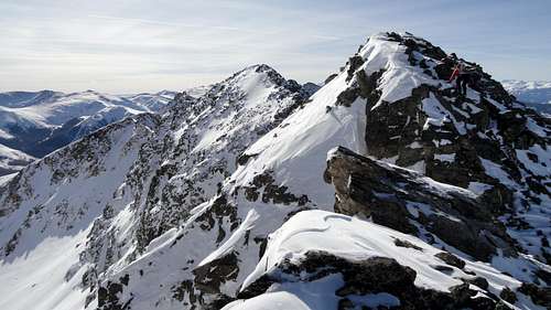
Atop Black Mountain the view of the traverse is daunting. The first matter of business is to cross a choppy knife edged section with exposure on both sides and then descend a steep face into a notch. There were good holds for this section but the snow was an issue. Faced in downclimbing was the norm and our axes were mostly useless in the shallow unconsolidated snow. Once in the notch we were faced with our second and hardest crux, a snowy, slabby arete with a nasty runout and no belay anchor.
![Black Mountain Summit]() Black Mountain Summit
Black Mountain Summit![Traverse to Lenawee]() Traverse to Lenawee
Traverse to Lenawee![Second Roped Pitch]() Second Roped Pitch
Second Roped Pitch
Standing at the base, we largely ignored the mass of rock and searched urgently for another route. Both sides were sheer slabs and did not offer an alternative. Neither of us wanted to lead the arete. For that matter neither of us wanted to belay the leader either! I finally sacked up for it and grabbed the gear. Tying in, I offered to rope solo until I got a piece in. Sarah declined and put me on belay. The plan was that if I peeled off to the right of the ridge she was going to jump off the left. The rope would go taut and our falls would equalize each other, slamming us into either side of the ridge, but we would live. Never in my wildest dreams did I think I would be in this situation. The only thought going through my brain was "Don't ****ing fall."
![Snowy Arete]() Snowy Arete
Snowy Arete
The best way to describe how I climbed this short pitch is "hugging an arete with one foothold and a single-handed side pull on the arete." During this my right hand was vigorously employed in digging through snow for another higher handhold or crack to place gear, while my right leg was dangling uselessly over a featureless slab. After a few sketchy moves on thin holds I found a shallow crack about 10 feet off the deck and plugged in a bomber cam. From here to the top the climbing eased and after topping out and crossing another exposed knife edge I built a belay in an alcove and brought Sarah up. Shaken by the scary pitch and realizing that we were running out of daylight, we were happy to descend off of this gendarme into a mellow saddle where we could take a break from the exposure and have a snack.
![Break Time]() Break Time
Break Time![Looking Back]() Looking Back
Looking BackLenawee: the hard way.
From the mellow saddle we cruised some much easier terrain before the ridge once again narrowed down to a cat walk and we resumed the previous method of "scooting across on our butts" when we weren't comfortable walking across the unstable snow. However, this section was short and before long we were on the mellow class 2 slopes of Lenawee Mountain. Gaining the summit ridge we traipsed up the cornice over the east face and celebrated our achievement as the sun began to drop. It was 4 PM and we had finally summited Lenawee Mountain.
![Rugged Ridge]() Rugged Ridge
Rugged Ridge![Summit Celebration]() Summit Celebration
Summit Celebration![Remaining Ridge]() Remaining Ridge
Remaining Ridge
Although we had high hopes to finish the traverse all the way to the upper slopes of A-Basin, we realized that it just wasn't going to happen. Our gear and our persons were soaking wet, we were dehydrated, physically exhausted, and the sun was setting. We made the tough decision to bail down a chute on the East Wall. We descended north west before dropping down a miserable talus and snow field which eventually cliffed out on us at the bottom. Traversing slightly to the north on more hard packed dirt, scree, and thin snow we found a weakness in the cliff bands and eventually got into a field of large talus and waist deep snow. Half way down the chute a couple of lift maintenance technicians at A-Basin had taken notice of us and as we made it down to the groomers they pulled up on snowmobiles and offered us a ride to the base of the mountain. Talk about descending in style! A few minutes and a harrowing snowmobile ride later we were at the base and one of the guys offered us a ride back up to Loveland Pass. We happily obliged and were eager to put this day to rest at 6 PM, ending yet another fine day in the Front Range.
![East Wall Descent]() East Wall Descent
East Wall Descent![Lenawee Face Sunset]() Lenawee Face Sunset
Lenawee Face Sunset![A-Basin at Dusk]() A-Basin at Dusk
A-Basin at Dusk


Comments
Post a Comment