
-
 16565 Hits
-
 90.13% Score
-
 31 Votes
|
|
Mountain/Rock |
|---|---|
|
|
45.68890°N / 7.36680°E |
|
|
10308 ft / 3142 m |
|
|
Overview
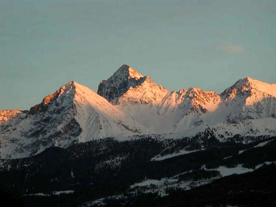
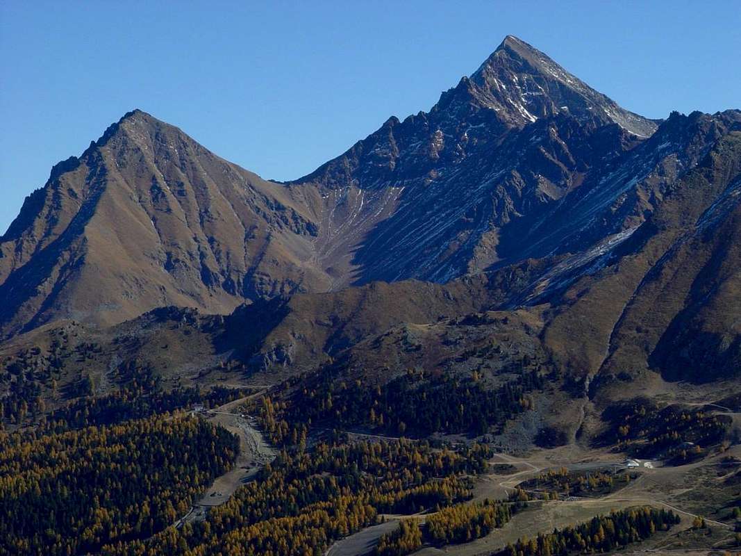
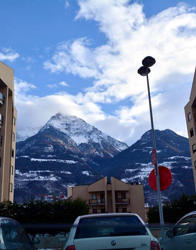
Becca di Nona is a top exactly above the Town of Aosta and, despite its height, looks smaller due to the impressive size of the Mont Emilius (3.559m), 400 meters higher, just behind it. Each year a lot of people hike the Becca di Nona (3.142m) through the two Standard Routes from Pila Resort, that is considered the symbolic mountain of the entire Aosta Town which dominates with more than 2.500 meters in altitude. The Normal Way is easy, a normal path where you simply walk up, nothing to scramble; it is quite long, consider at least 4 hours for a difference in height of 1.463 meters. Do not forget that you expect an equally long return.
La Becca di Nona è una montagna collocata esattamente sopra alla Città d'Aosta e, nonostante la sua altezza abbastanza ragguardevole, sembra più piccola del reale a causa dell'imponente mole del Monte Emilius (3.559 m), 400 metri più alto, appena alle spalle della medesima. Ogni anno molte persone compiono quest'escursione alla Becca di Nona (3.142 m) raggiungendola per mezzo delle sue due Vie Normali prendendo le mosse dal Centro Turistico di Pila, anche per il fatto che viene considerata quale montagna simbolo dell'intera Città di Aosta sulla quale incombe dall'alto di oltre 2.500 metri. La Via Normale è facile, un percorso semplice, in cui è sufficiente camminare senza alcuna arrampicata; comunque la gita è abbastanza lunga e tal da richiedere almeno 4 ore per un dislivello complessivo di 1.463 metri. Non scordatevi che vi attende un altrettanto lungo ritorno.
 |
 |
Topographic Notes
TOPOGRAPHICAL REMARKS By analyzing the structure of the mountain (five crests and as many faces) in a clockwise direction starting from the East to return to the East.long ridge of 950 meters that descend to Arpisson; rarely ascent. Ends with a triangular wall of 500 meters, still do not climb, above the moraine.
East-southeast Slope: small triangular slope of about 270 meters above Lake Peckoz; useless and tiring climb but useful in descent, if with snow via a beautiful "slide". Generally it is simply "lapped" just claim and skip in the ascent of the terminal part of the S-SE Crest before it reaches the mule track from the S-SW side. Knowing how to search, in its middle part there is a small and fresh spring of water in a little ravine in the transversal band of rocks in the middle of the slope.
South-southeast Crest: via a small easy crest that rises from the Hill Carrel (at the Federigo Bivouac) of 230 meters; likely route of the first climber, certainly for the first winter. The same goes up on a small earthy track, which further up breaks into an area of rotten rocks that progressively lean on the right or East-southeast side, leaving the South-southeast side on the left (South). Just above the hill you can hear the Echo coming from the North Face of the Emilius.
South-southeast Slope: very narrow grassy-rocky slope that drops above the Grand Scez small tableland, near the fork of the two paths to Becca di Nona or towards Colle Carrel. Useless and dangerous to climb it consists in a rocky slope, often covered by dangerous grass, above the small Gran Scez plateau (2.526m), just above the junction of the two preceding paths on altitude of 2.778m. Is a little in the shape of a narrow and very elongated obtuse triangle S-SE Wall of about 350/65 meters as a small grassy-rocky face above the squared boulder of Gros Scez or the Grand Sax, so called for the local inhabitants.
South little Crest: divides the narrow side prior to the much more extensive or South-southwest. It can be useful in case of snow, allowing a more rapid ascent and also safe, as well as less boring and more fun, also because it allows you to climb, albeit easily for several sections (I° and II°), remaining above the South-Southeast Side or, better, between the latter and the mule track of the South-Southwest Slope. Definitely a choice for connoisseurs of the territory ...
South-southwest Slope: consists of several ribs alternating with grassy-rocky couloirs of which the most visible is the central one that from Plan Valé climbs directly to the Summit with over 700 meters of altitude; on Eastern margin salt an old mule track, built in 1860 for the laying of the great statue of the Madonna, which is the route most commonly used (at least until the construction in 1984 of the Federigo Zullo Bivouac at Carrel Pass). Already risen even in winter.
West-southwest Great Rib: Western margin of the previous ends on the West Ridge near the Top, was climbed for a one time mistake; totally inadvisable as it covered a lot of grass. In any case, once you have reached Plan di Valé, you have to turn left or NW towards some greyish and transversely elongated moraines; once you have reached and passed them, continue along the edge of the grassy ribbing-ridge until you reach the final rocks and the West Ridge.
West Ridge: long ridge of about 1.000 meters, which splits the altitude of 2.686 meters; you can go from Comboé or with a crossing to the North by Plan Valé, bypassing a rocky-grassy channel just beyond the West-southwest Great Rib. At the top of the previous rib meets near 120 meters from the Summit; from the rocky and vertical promontory (2.686m) down to the Northwest a cliff of 450 meters above Ponteilles. Extremely panoramic climb but inadvisable for the grass.
North Wall: great wall of 850 meters down on the rocky promontory of the Morion, crossed in its middle by a large channel; at the side of the same rise its great pillars twins. On the same were drawn different routes, all dangerous and exposed to falling rocks. In addition, the rock is often march; this ascension requires care and experience. as well as a good degree of preparation and training. All routes require caution in climbing, also due to the precariousness of the rock that does not allow for good possibilities of protection. In fact, in all the routes carried out, no type of artificial protection was used (see nailing of the rock). The more challenging routes are found, in addition to the Central gully (June 1999), on some "mixed" routes with combinations of various sectors, such as: North Face Via del Canalino on the left (July 1966) and the final part on the Grande Torre 2.998 meters (June 2008), located on the N-NE "Crestone" (June 1926), or the Northwest Face of the promontory 2.686 meters (December 2007) and West-northwest Crest (June 1967).
North-northeast "Crestone": this ridge descends 1.200 meters in altitude above the ancient Alp Croix Plan; from the peak reached after a layer of rock of 110/20 meters, a jag at an altitude of 2.736 meters, called "Tooth of Becca". Then he goes on less rocky, covered with forest that ends with a cliff above the Martsaouchy Damon Alp. Surely it is the most beautiful and safe way to the mountain, even if on the rocks is often encountered lichen that makes the climbing delicate. Already climbed, a unique time, in winter 1985, with in addition to the June 1926 route of the first climbers, two symmetric lateral variants on the sides of the initial rocky slab (August 1967 on the left edge or little corner with East Face and August 1969 integrally on the watershed with North Face on the right). Also reached with combinations of ascents both with the North Face, above the Morion, (July 1969, September 1978 and June 2008) and from the Eastern Wall, above the Arpisson (August and September 2007). Also traveled solo (Summer 1958) and solo as well as the first winter ascent (December 1985), it was also climbed several times during the day, both starting from Pila Resort, Comboé Alp and integrally in ascent on entire Northern Buttress from Martsaouchy Damon (July 2006). On one sole occasion, however, it was run downhill with the first female route (Summer of 1940); during this day the crossing was also made coming from Monte Emilius, after the ascent of the same through the N-NE "Spigolo" (Edge) and descent to the W-NW Ridge (current Via Ferrata from Col Carrel).
East-northeast Wall: certainly constitutes the most challenging route; is "hidden" on top of a small secondary vallon to that of Arpisson at the footh of Northern Wall of Monte Emilius (3.559m). Its height varies from 400 meters in the South sector (the most difficult) up to 600 meters opposite. Divided in its middle by a ridge that reaches the East-northeast Crest just before the Summit (about 50 meters), while the base is surrounded from a rocky vertical jump of about a hundred meters. Ascension fairly difficult (AD +; a initial step of V°), which requires the ability to know how to choose the via. Even the two variants opened in solo ascent in August and September 2007 are not easy to climb (III°/III°+ with some short stretches of IV°-) and require attention and experience due to the presence of really dangerous "ollina" grass on the rock in itself already unsafe, as it is often fragile and crumbly or covered with slippery moss.Even the approach is long and tiring, a factor that, in addition to not being in sight, precludes it from a good attendance. Better this way, because on its northernmost edge a fatal accident has already occurred for a young boy (Gianfranco Zafferetti) from Plan Félinaz, while another boy fell in the upper part below the Top to go and collect edelweis. Surely they are not places for inexperienced, but even those with mountain experience must look at them with precautionary attention ...
 |
 |
 |
 |
 |
Cresta Est-nordest: lunga cresta di 950 metri sopra il Vallone d'Arpisson; raramente salita. Finisce con una parete triangolare di 500 metri, ancora non salita, sopra la morena.
Versante Est-sudest: pendio triangolare di circa 270 metri sopra il Laghetto Peckoz; inutile e faticoso salendo, ma valido in discesa con neve consentendo una bella "scivolata". In genere viene semplicemente "lambito" nella salita della parte terminale della Crestina Sud-sudest prima di raggiungere la mulattiera dal Versante Sud-sudovest. Sapendo cercare, nella sua parte mediana si trova una piccola e fresca sorgente d'acqua in un anfratto nella fascia trasversale di rocce.
Cresta Sud-sudest: facile crestina risalente dal Colle Carrel (Bivacco Federigo) di 230 metri; probabile percorso per la prima salita, certamente per la prima invernale 1889. La stessa risale su di una piccola traccia terrosa, che più in alto si infrange in una zona di roccette marce che progressivamente si appoggiano sul lato di destra o Versante E-SE lasciando sulla sinistra (Sud) il Versante S-SE. Sopra al colle si può sentire l'Eco proveniente dalla Parete Nord dell'Emilius.
Versante Sud-sudest: pendio erboso-roccioso che da quota 2.778 metri si eleva al di sopra del piccolo altopiano del Gran Scez, nei pressi del bivio dei due sentieri per la Becca di Nona oppure per il Colle Carrel. Inutile e pericoloso a salirsi. Consiste in una Paretina S-SE di circa 350/65 metri; piccola faccia erboso-rocciosa a forma di triangolo ottusangolo stretto nonché molto allungato al di sopra del roccione squadrato del Gros Scez oppure le Grand Sax (2.526 m).
Crestina Sud: divisoria il lato precedente dal molto più esteso Versante Sud-sudovest. Può essere utile in caso di neve alta, consentendo una salita più rapida oltreché sicura, oltre a che meno noiosa e più divertente, anche perché permette di arrampicare, anche se facilmente per diversi tratti (I° e II°) restando al di sopra del Versante Sud-sudest o, meglio, tra quest'ultimo e la mulattiera del Versante Sud-sudovest. Sicuramente una scelta da conoscitori del territorio ...
Versante Sud-sudovest: si compone di diversi costoloni alternantisi a canaloni erboso-rocciosi, dei quali il più in vista risulta essere quello centrale che da Plan Valé sale direttamente alla Vetta con oltre 700 metri di dislivello; sul suo margine Orientale sale una vecchia mulattiera, costruita nel 1860 per la posa della grande statua della Madonna, via la più comunemente usata (almeno fino alla costruzione nel 1984 del Bivacco Federigo Zullo). Già percorso d' inverno.
Costolone Ovest-sudovest: al margine Occidentale del precedente termina sulla cresta Ovest nella sua parte superiore; è stato salito "per sbaglio" una sola volta; totalmente sconsigliabile in quanto coperto da ripidi strati erbosi nella parte più bassa e da rocce molto rotte se non addirittura finemente disgregate verso l'alto sotto la Cresta Ovest. In ogni caso, raggiunto il Plan di Valé, si deve svoltare a sinistra o NO in direzione di alcune morene grigiastre ed allungate trasversalmente; raggiunte e superate le stesse, continuare sul filo del costolone erboso fino a raggiungere le roccette finali e la Cresta Ovest.
Cresta Ovest: lunga cresta con circa 1.000 metri di dislivello dividentesi a quota 2.686 metri su di un promontorio roccioso; si può salire direttamente dal Basso Comboé o con una traversata a Settentrione dal Pian di Valé, oltrepassando un canalone erboso-roccioso subito dietro il Costolone Ovest-sudovest. S'incontra nella parte superiore con il precedente costolone a circa 120 metri dalla Cima; dal verticalre e roccioso promontorio (2.686 m) scende verso Nordovest sopra la Cascata di Ponteilles un salto roccioso di 450 metri. Oltremodo panoramica, ma sconsigliabile per la roccia molto rotta, spesso con pericolosa erba "ollina".
Parete Nord: paretone triangolare di 850 metri rivolto sopra il promontorio roccioso del Morion, attraversata nel mezzo da un grande canalone; a lato innalza due grandi pilastri gemelli. Sulla stessa sono stati tracciati diverse vie, tutte pericolose ed esposte alla caduta di sassi. Inoltre, la roccia è spesso marcia; quest'ascensione richiede attenzione ed esperienza, oltre a che un buon grado di preparazione ed allenamento. Tutte le vie richiedono circospezione nel muoversi in arrampicata, anche a causa della precarietà della roccia tale da non permettere buone possibilità di protezione. In tutte le vie effettuate non risulta infatti l'impiego di nessun tipo di protezione artificiale (vedi chiodatura della roccia). Le vie più impegnative si trovano, oltre al canalone Centrale (Giugno 1999), su alcune vie "miste" con le combinazioni tra vari settori, tipo: Parete Nord Via del Canalino di sinistra (Luglio 1966) e parte conclusiva sulla Grande Torre 2.998 metri (Giugno 2008), sita sul "Crestone" N-NE (Giugno 1926), o Parete Nordovest del promontorio 2.686 metri (Dicembre 2007) e Cresta O-NO (Giugno1967).
"Crestone" Nord-nordest: crinale di 1.200 metri d'altezza sopra l'antica Alpe di Plan Croix scende sin sopra una grande placca di 110/20 metri, raggiungendo un dente a quota 2.736 metri, detto "Dente della Becca". Poi prosegue in basso meno rocciosa e ricoperta da foresta per terminare con un notevole salto roccioso sopra l'Alpe di Martsaouchy Damon. Sicuramente è la via più bella e sicura della montagna, anche se sulle rocce s'incontra spesso del lichene tal da render l'arrampicata delicata. Già. Già salito anche d'inverno nel 1985, presenta, oltre alla Via del Giugno 1926 dei primi salitori, due varianti laterali su entrambi i lati della placca rocciosa iniziale (Agosto 1967 sul margine o spigoletto di sinistra con la Parete Est ed Agosto 1969 integralmente sullo spartiacque con la Parete Nord di destra). Raggiunto anche con combinazioni di salita sia con la Parete Nord, sopra il Morion, (Luglio 1969, Settembre 1978 e Giugno 2008), che dalla Parete Orientale (Agosto e Settembre 2007), sopra l'Arpisson. Percorso anche in solitaria (Estate 1958) nonché in solitaria ed in prima scalata Invernale (Dicembre 1985), é stato salito inoltre diverse volte in giornata sia partendo dal Comprensorio di Pila che dalle Alpi di Comboé ed integralmente da Martsaouchy Damon, percorrendo l'intero Contrafforte Settentrionale (Luglio 2006). In un'unica occasione, invece, é stato fatto in discesa con primo percorso femminile (Estate 1940); durante questa giornata é stato effettuata anche la traversata arrivando dal Monte Emilius, dopo la salita dello stesso tramite lo Spigolo N-NE e discesa per la Cresta O-NO verso il Piccolo Emilius, Mont Ròss de Comboé e Col Carrel (attuale Via Ferrata dal Bivacco Federigo Zullo 2.907 metri).
Parete Est-nordest: certamente costituisce la via più impegnativa; é "occultata" in cima ad un valloncello secondario a quello dell'Arpisson. La sua altezza varia da 400 metri nel settore Meridionale (il più difficile) fino a 600 metri all'opposto. Divisa al suo centro da un crestone che raggiunge la Cresta Nord-nordest poco prima della Vetta, mentre la base è cinta da un salto verticale di roccia di circa un centinaio di metri. Ascensione abbastanza difficile (AD+, un passaggio di V°), richiedente la capacità di saper individuare la via. Anche le due varianti aperte in solitaria ad agosto e settembre del 2007 non sono di facile salita (III°/III°+ con qualche breve tratto di IV°-) e richiedono attenzione ed esperienza per la presenza di veramente pericolosa erba "ollina" sulla roccia di per se già poco sicura, poiché spesso fragile e friabile oppure ricoperta da scivoloso muschio. Anche l'avvicinamento risulta lungo e faticoso, fattore che, oltre a non essere in vista, la preclude da una buona frequentazione. Meglio così, perché sul suo estremo margine Settentrionale si é già verificato un incidente mortale per un giovane ragazzo di Plan Félinaz (Gianfranco Zafferetti), mentre un altro ragazzo é caduto nella parte alta sotto la Vetta per andare a raccogliere le stelle alpine. Sicuramente non sono posti per inesperti, ma anche chi possiede esperienza di montagna se ne deve guardare con somma precauzione ...
First Ascents
 |
 |
 |
 |
 |
- First on the Summit: Engineer Alberto Casalegno topographer by S.M.S., (Summer 1832), in ascent from Comboé Valley and, more probably, Carrel Pass and S-SE Crest.
- In winter: Alessandro Emilio Martelli, Silvio Miglietti with Valtournanche Mountain Guide Jean Baptiste Aymonod, (Dec 20th, 1889), in ascent from Comboé surely by S-SE Crest. Second winter ascent: Amilcare Crétier, F. David, Albert Deffeyes, Giuseppe Lamastra, Basile Ollietti, Guido Perolino and Louis Pession, (Mar 19th, 1928), by Ski from Comboé, Carrel Pass. Third winter ascent: Osvaldo Cardellina and Camillo Roberto Ferronato, (Dec 23th, 1977), in day from Pila, Colle Plan Fenêtre, Comboé Vallon, Plan Valé, Gros Scez and through the S-SW Slope or Normal Via.
- S-SE Crest (Alternative Normal Route): probably Captain Alberto Casalegno, (Summer 1832).
- S-SE Face (above Gros Scez): Osvaldo Cardellina, lone, (Jul 03th, 2007), in ascent in day from Les Pousses or Pouces Pastures, Ponteilles Alp and Waterfall, Comboé Vallon, Plan Valé and just over the squared Gros Scez or le Grand Sax on Western Slope of Carrel Pass.
- S little E'peron: Osvaldo Cardellina, lone, (Jun 23th, 1996), in ascent in day from Pila, Col Plan Fenêtre, Comboé, Gros Scez.
- S-SW Slope (Standard Route): Unnknown. First winter: Osvaldo Cardellina and Camillo Roberto Ferronato, (Dec 23th, 1977), in day from Pila, Colle Plan Fenêtre, Comboé Vallon, Plan Valé.
- S-SW Couloir (third from right or East): Osvaldo Cardellina, lone, (Oct 14th, 2007), in ascent from Pila, Comboé, Gros Scez.
- W-SW Slope (more Western Rib): Ilario Antonio Garzotto, Osvaldo Cardellina, Dario Sergio Cardellina and Arturo Jemma, (Sep 03th, 1964), in ascent directly in day from Pian Felina (569m), Reverier, Ponteilles, Comboé, Plan Valé.
- W Ridge: Osvaldo Cardellina, lone, (Jun 13th, 1967), in ascent in day from Pila, Comboé, with diagonal traverse from Plan Valé to North.
- W-NW Ridge (Integral): Osvaldo Cardellina, lone, (Jun 26th, 1970), in ascent in day from Pila, Comboé.
- NW Wall (promontory 2.686m) and W-NW Ridge: Osvaldo Cardellina, lone, (Dec 31th, 2007), in ascent in day from Ponteilles and Low Comboé.
- N Wall and NW Edge (Tower 2.998m) and N-NE Ridge: Osvaldo Cardellina, lone, (Jun 05th, 2008), in ascent in day from Pila through Morion Alp.
- N Wall (Western Couloir): Osvaldo Cardellina, lone, (Oct 11th, 2007), in ascent in day from Saint Salò, Ponteilles, Morion Alp.
- N Wall (Western Spur): Giulio Adolfo "Dulo" Ourlaz, lone, (Summer 1940), in ascent surely in day from Pila. First repetition: Renato Quendoz, lone, (Summer 1964), surely in day from Pila, Colle Plan Fenêtre, Morion Alp. Second repetition and first winter on the North Wall: Osvaldo Cardellina, lone, (March 20th, 2007), in day from Pila, Colle Plan Fenêtre, Morion Alp; in descent to Col Carrel, Federigo Bivouac, Comboé, Colle Plan Fenêtre, Pila.
- N Wall (Central Couloir): Osvaldo Cardellina, lone, (Jun 27th, 1999), in ascent in day from Les Pousses, Ponteilles, Low Comboé, Morion Alp (ruines).
 |
 |
 |
 |
 |
- N Wall (East & West Pillars): Michele Baratono, Federico Chabod and Mario Schiagno, (Jul 12th, 1920), in ascent from Saint Salò, Ponteilles, Morion Alp. First repetition integral and complete: Osvaldo Cardellina, lone, (Jun 07th, 2009); in day from Pila, Col Plan Fenêtre, Lower Comboé, Morion Alp.
- N Wall (West Side of East Pillar): Osvaldo Cardellina, Ines Alasonatti and Giuseppe Lamazzi, (Jul 12th, 1996), ascent in day from Ponteilles, Morion Alp.
- N Wall (East Side East Pillar and N-NE Crest): Osvaldo Cardellina and Bruno Pagliarin, (Jul 10th, 1969), in ascent in day from Pila, Lower Comboé, Morion Alp. First repetition: Osvaldo Cardellina, solo, (Oct 23th, 2005); in day from Reverier, Cretaz Nuaz, Le Champex, Ponteilles, "Low Comboé", Morion Alp
- N Wall (Rib under triangular snowfield and N-NE Crest): Osvaldo Cardellina and Camillo Roberto Ferronato, (Sep 24th, 1978), in day from Pila, Morion Alp.
- N Wall (East little Couloir): Ilario Antonio Garzotto, Dario Sergio Cardellina and Walter Ferronato, (Jul 24th, 1966), in ascent in day from Pian Felina, Ponteilles, Morion Alp. First repetition: Ilario Antonio Garzotto and Osvaldo Cardellina, (Aug 13th, 1967), in day from Gorres, Ponteilles, Morion Alp.
- N-NE Ridge (Integral Edge): Ilario Antonio Garzotto and Osvaldo Cardellina, (Aug 24th, 1969), in ascent in day from Gorres-Saint Salò. Ponteilles, Morion
- N-NE Ridge (Central Via on plate): Amilcare Crétier and Guido Perolino, (Jun 20th, 1926), in ascent in two days from Arpisson Alp (bivouac). First repetition: Adolfo Giulio Ourlaz with wife Aurora Wuillerminaz, (Jul 20th, 1941), in descent after the crossing on Monte Emilius. First lone: Angelo Bozzetti, (Summer 1958), in ascent from Pila, Comboé. First winter Alberto Sciardi, (December 22th, 1985), in ascent from Pila, Comboé.
- N-NE Ridge (East Edge): Osvaldo Cardellina and Massimo Centelleghe, (Aug 03th, 1967), in ascent in two days from Pila, Low Comboé, Morion Alp.
- First repetition: Vincent Bianchi and Marco Gaida, (Jul 27th, 2006), integrally from Martsaouchy Damon, Plan Croix Alp, passing the "Becca Tooth" in right.
- E Face (Central Via in South Sector): Amilcare Crétier, Guido Perolino and Giuseppe Riconda, (Jun 12th, 1927), in ascent in two days from Arpisson Alp.
- E Face (Left Route into the Southern Sector): Osvaldo Cardellina, lone, (Jul 04th, 1996), before in descent from the Top through E-NE Ridge and in ascent after traverse from small fork about 2.880 meters.
- E Face (Right Route double Variant into the Southern Sector): Osvaldo Cardellina, Camillo Roberto Ferronato and Giuseppe Lamazzi, (Jul 17th, 1978), in ascent in day from Martsaouchy du Meitin, Arpisson.
- E-NE Wall of Eastern Face (Right Route into the Northern Sector to "Greeat Tower" 2998 meters): Osvaldo Cardellina, lone, (Aug 23th, 2007), in ascent from Revererier Dessous, Martsauchy Damon, Plan Croix, Arpisson Lower and Higher Pastures.
- E-NE Edge of Eastern Face (Left Route into the Nortthern Sector to "Le Pouce's Collar" about 3.055/65 meters): Osvaldo Cardellina, lone, (Sep 05th, 2007), in ascent from Revererier Dessous, Martsauchy Damon, Plan Croix, Arpisson Lower and Higher Pastures.
- E-NE Edge of Eastern Face (Superior part after traverse from over the "Gendarmes" to Top): Osvaldo Cardellina and Massimo Centelleghe (Aug 02/03th, 1967), in ascent from Aosta, Charvensod, Revererier Dessous, Revererier Dessus, Ponteilles, Comboé, Morion. Pastures.
- E-NE Ridge (Upper part): Amilcare Crétier, Renato Chabod and Alliod; (Jun 31th, 1923), in ascent from Arpisson Alp. In descent: Ilario Antonio Garzotto and Osvaldo Cardellina; (Jul 25th, 1965), in day arriving from the Summit. Repeated in ascent: Marco Cossard and Giuseppe Lamazzi (mid-Seventies), in ascent in day from Martsaouchy du Meitin, Arpisson Lower and Higher.
 |
 |
 |
 |
 |
With
In Aosta City, follow the direction Pila, left side of the town (South) if you come from East (Turin also Milan). In Pila (1.814m), park your car close to the start of the cableway for the Chamolé Lake. At this point you can choose:a) - take the cableway, follow the indication Chamolé Lake (2.325m), hike the Replan Pass, (2.459m), immediately left of the lake, come down to the Alp of Comboe', 2.100m (take care, the path is very steep e some time disappears);
b) - you can see a large path that brings to San Grato Hermitage, left side, crossing the direction of the cableway; follow this path, after the small sanctuary, with the indications towards Saint Grat and Chamolé Pasture to reach Comboé Valley. There is also another path, that follows more o less the way of a mountain bike trail; the indication is always Alp Comboé.
Dalla Città d'Aosta, seguire la direzione per la Conca di Pila; la stessa é collocata a sinistra del lato della città (Sud) per chi proviene da Est (Torino o Milano). A Pila (1.814 m), parcheggiare l'auto vicino alla partenza della funivia per il Lago di Chamolé. A questo punto è possibile scegliere:
 |
 |
 |
 |
 |
a) - prendere la funivia, seguire le indicazioni per il Lago di Chamolé (2.325 m), scavalcare il Col Replan, (2.459 m), subito sulla sinistra del lago, scendere all'Alpe del Comboé', (2.100 m; scendere con una certa attenzione poiché il sentiero è piuttosto ripido ed a tratti par scomparire);
b) - inoltre si può vedere sulla sinistra (Est) una grande sterrata adducente all'Eremitaggio di San Grato, attraversando il tragitto della funivia; seguire questa strada poderale fino al raggiungimento del medesimo; con l'indicazione per le Alpi di San Grato e Chamolé si raggiunge il Vallone del Comboé. Esiste anche un percorso alternativo, che segue più o meno la via d'una pista di mountain bike; le segnalazioni son sempre per il Comboé.
 |
Routes & Descent
When you reach the Alpi Comboe' (2.100m), more o less after 1h'30, (here you can take the last drinking water, in case you need) follow the large valley till a bridge, and look for the path number 16, on your left; in two hours and a half 3 hours this brings directly to the top; the path is sometimes very steep, but always quite wide. From the top, where a statue of the Virgin has been erected, the view is fantastic on the most important tops of the Aosta valley; back side, the imponent Northern Wall of the Monte Emilius.Downhill by Alternative Route Coming back from the top, it is possible to change partially the way; at the feet of Monte Emilus, behind you, you can see the Carrel Pass with the bivouac Federigo, (2.897m); this bivouac can be used to climb the North face of Monte Emilius. Come down along the steep path straight on the Carrel Pass (left side there is a small lake); from the pass, another path (recently restored) will bring you to the same one that you walked up in the morning. Bypassed the Comboe' Alp, the easiest way is to hike the Pian Fenetre Pass, (2.221m); after the pass, the path winds in a nice bush; at a certain point there is a deviation without any indication; go straight on, not down, till the Chamole' Alp, (2.150m); the path winds in front of the farms (South), and reaches the border of a pine forest, down till Pila, crossing the mountain bike trial.
Raggiunto l'Alpeggio del Comboé (2.100 m), in circa 1h'30, (qui meglio prender l'ultima acqua potabile, in caso di necessità), seguire per poco il vallone insino ad un ponticello in legno e ricercare il sentiero numero 16, sulla vostra sinistra; in due ore e mezza 3 ore questo porta direttamente alla parte superiore; il percorso è a tratti alquanto ripido, ma tal da offrire sempre un sentiero abbastanza largo. Dalla cima, dove è stata eretta una statua della Vergine, la vista è fantastica sulle cime più importanti della Val d'Aosta; mentre a tergo s'erge l'imponente Parete Nord dell'Emilius.
 |
 |
 |
 |
 |
In discesa con Via Alternativa Tornando dall'alto, è possibile cambiare parzialmente il percorso; ai piedi del Monte Emilus, sotto di voi, si può vedere il col Carrel con il vicino Bivacco Federigo Zullo (2.897 m); il medesimo può essere utilizzato per scalare la Parete Nord del Monte Emilius. Con questo percorso alternativo scendere lungo il ripido sentierino direttamente sul Col Carrel (sulla sinistro s'evidenzia un laghetto); dal bivacco un sentiero (di recente ristrutturato) con altro percorso vi porterà alla stessa via del mattino. Ripassando a lato dell'Alpe di Comboé, il modo più semplice per rientrare consiste nel percorrere il sentierino che risale al Col Plan Fenetre (2.221 m); dopo il colle, il percorso si snoda tranquillo attraverso alcuni cespugli; ad un certo punto c'è una deviazione verso il basso senza alcuna indicazione (ripa discesa a San Grato); proseguire invece in modo rettilineo raggiungendo l'Alpe di Chamole (2.150 m); il percorso si snoda davanti alle fattorie (Sud), e raggiunge il bordo d'una pineta per poi discendere fino a Pila, attraversando il percorsoo delle mountain bike.
Giugno, Luglio, Agosto, Settembre, anche Ottobre, a seconda della stagione. In Sci-Alpinismo: da fine Marzo in poi, a seconda delle condizioni; il pendio è molto ripido e tecnico, e abbastanza pericoloso in caso di neve fresca.
Red Tape
No restriction at all. |
Nessuna restrizione per tutti.
When To Climb
June, July, August, September, even October, according to the season; Ski mountanering: end of March on, according the conditions; the slope is very steep and tecnical, very dangerous in case of fresh snow.
 |
 |
 |
 |
 |
Campings
Remember that free camping is forbidden (except for emergency reasons, over 2.500m, from darkness until dawn).Mountain Condition
- Meteo: you can find all the needed informations at the official site of the Valle d'Aosta Region:
- Valle d'Aosta Meteo
Webcam
- WEBCAM on Aosta Valley:
- Webcam
Books and Maps
BOOKS:- "Guida del Monte Emilius", di Osvaldo Cardellina Editore in collaborazione con il Club Alpino Italiano Sezione di Aosta, Dicembre 1978.
- "Guida dei Monti d'Italia – Emilius Rosa dei Banchi Parco del Mont Avic" di Giulio Berutto e Lino Fornelli - Club Alpino Italiano/Touring Club Italiano, Marzo 2005.
- "Guida delle Alpi Occidentali" di Giovanni Bobba e Luigi Vaccarone C.A.I. Sezione di Torino Volume II (parte II), 25 Maggio 1896.
- "80 itinerari di Escursionismo Alpinismo e Sci Alpinismo in Valle d'Aosta", di Osvaldo Cardellina, Ed. Musumeci, Giugno 1977 (in Italian); seconda Ed. Luglio 1981; terza Ed. Luglio 1984; (in French), prima Ed. Febbraio 1978; seconda Ed. Marzo 1980.
- "Diari Alpinistici" di Osvaldo Cardellina e Indice Generale accompagnato da Schedario Relazioni Ascensioni 1964-2019 (inediti).
 |
 |
 |
MAPS:
- Kompass "Gran Paradiso Valle d'Aosta Sentieri e Rifugi" Carta turistica 1:50.000.
- L'Escursionista "Conca di Aosta-Pila-Monte Emilius" Carta dei sentieri (n° 4) 1:25.000.
- Hapax "Les Sentiers Comunità Montana Monte Emilius", Luglio 2000 1:25.000.
- Enrico Editore Ivrea-Aosta "Gruppo del Gran Paradiso" 1:50.000.
- I.G.C. Istituto Geografico Centrale, Torino "Carta delle Passeggiate ed Escursioni in V.D.A. Conca di Pila-Gressan, 1:20.000.
Important Information
- REGIONE AUTONOMA VALLE D'AOSTA the official site.
- FONDAZIONE MONTAGNA SICURA Villa Cameron, località Villard de la Palud n° 1 Courmayeur (AO) Tel: 39 0165 897602 - Fax: 39 0165 897647.
- A.I.NE.VA. (Associazione Interregionale Neve e Valanghe).
Useful numbers
- Protezione Civile Valdostana località Aeroporto n° 7/A Saint Christophe (Ao) Tel. 0165-238222.
- Bollettino Valanghe Tel. 0165-776300.
- Bollettino Meteo Tel. 0165-44113.
- Unità Operativa di Soccorso Sanitario Tel. 118.
Acknowledgements
I am greatly indebted to my friend "Osva" for all texts, detailed description of the routes and translation.